To Kwa Wan
To Kwa Wan (traditional Chinese: 土瓜灣; simplified Chinese: 土瓜湾; Jyutping: tou2 gwaa1 waan1; pinyin: Tǔguāwān) is a bay and an area of the eastern shore of Kowloon peninsula. The area is part of urban Hong Kong, and is situated between Hok Yuen, Hung Hom, Ma Tau Wai and Ma Tau Kok. Administratively, the area belongs to the Kowloon City District of Kowloon.


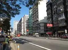

To Kwa Wan is a mixed residential and commercial area, located to the west of the old Kai Tak Airport.
Isolated from the MTR rail network, it comprises mostly mid-20th century residential and light industrial architecture of 10 or fewer floors, built to comply with height restrictions for the former Kai Tak Airport. Since the airport closed in 1998, new buildings are taller, often with commercial space on the ground floor, especially along major roads such a Ma Tau Wai Road. Consequently, the area has a much-valued cohesive community spirit.[1]
A new rail link is set to open in late 2020 or early 2021.
History
The name 'To Kwa Wan' literally means 'Potato Bay', named for the sweet potatoes formerly grown here by local Hakka people. From the 19th century, a nearby granite quarry provided construction materials, including for the development of Kai Tak Airport.[1]
After World War II, light industrial units sprang up, making products such as toys and textiles. Housing rose concurrently with factory buildings, and in the 1970s the area's public housing estates were built to relieve pressure in other crowded areas of Kowloon.[1]
Poor building standards and ageing have been highlighted by crumbling facades that have hurt or killed people in the area. The demolition of older flats has allowed developers to acquire land in To Kwa Wan to build newer and more profitable residential flats.[2][3]
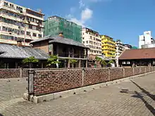
Green space
Alongside high-density residential and commercial zoning, there are a few green spaces in To Kwa Wan:
- Hoi Sam Park - park facing Kowloon Bay
- Ko Shan Road Park
- To Kwa Wan Recreation Ground
With extensive land reclamation in the early 1970s, Hoi Sham Island, formerly located in the adjacent bay, was incorporated into the peninsula, becoming Hoi Sham Park.[4]
Transportation
There only a few main roads in the area. All other roads are side streets serving local residents. To Kwa Wan Road and Ma Tau Wai Road form a V-shaped corridor, while the East Kowloon Corridor is an elevated highway passing through the middle of To Kwa Wan.
The Kowloon City Pier Bus Terminus to the north services several local bus routes.
When the new Sha Tin to Central Link rail line opens (due late 2020 or early 2021), To Kwa Wan station will serve the area, in anticipation of which new development is already taking place.[1]
See also
References
| Wikimedia Commons has media related to To Kwa Wan. |
- Neighbourhood Guide: A Sense of Community in To Kwa Wan. Zolima City Mag, 6 September 2018
- "Magazine 94 the collapse of to kwa wan". Squarefoot.com.hk. Retrieved 11 December 2016.
- "Travel in Kowloon > To Kwa Wan". Thaiworldview.com. Retrieved 11 December 2016.
- Island Stories, Part II: Hong Kong’s Disappearing Islands, Zolima City Mag, 25 July 2018
