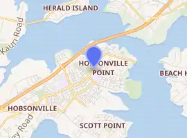
Hobsonville
Hobsonville is a rural suburban district in the Auckland Region in the North Island of New Zealand. The area was administered by Waitakere City Council until the council was amalgamated into Auckland Council in 2010.
Hobsonville | |
|---|---|
Suburb | |
| |
| Country | New Zealand |
| Local authority | Auckland Council |
| Population (2018) | |
| • Total | 4,938 |
| Ferry terminal(s) | Hobsonville Point |
| Whenuapai | Herald Island | Greenhithe |
| State Highway 16 |
|
Upper Harbour Bridge |
| West Harbour | Waitematā Harbour |
Hobsonville Point, formerly the location of the Royal New Zealand Air Force's airfield, Hobsonville Airbase, is currently being redeveloped as a new suburb of Auckland. Hobsonville Village next to Hobsonville Point is also being developed by Auckland Council, and the area known as Hobsonville Corridor joins the peninsula with Westgate, a new regional town being created by the council. The peninsula is joined by the North Western Motorway and State Highway 16 in the west and the Hobsonville Peninsula and Upper Harbour Bridge in the east.[1]
History

Hobsonville was named after the first Governor of New Zealand, William Hobson. After landing by sea at the site, Hobson thought it suitable as the seat of Government for New Zealand but later rejected this on the advice of the Surveyor-General of New Zealand, Felton Matthew.[2] After the signing of the Treaty of Waitangi, Okiato (renamed Russell), was chosen as the capital instead.
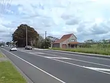
Originally Hobsonville was mainly an agricultural and horticultural area. During the early history of Auckland, large clay- and brickworks operated in the area such as in Limeburners Bay and at the Clark's Brickworks.[1] The brickworks clay piping production was used to reticulate much of the new Auckland city centre, bringing in much of Clark's wealth.
The latter works was located on the shore to the southwest of Bannings Way, with Clark himself living in 'Clark House', currently occupied by the RNZAF Aviation Medicine Unit, on Clark Road. Servants' quarters were located adjacent to the Hobsonville shopping centre and are in a design similar to Clark House, but single storeyed. The servants' quarters have subsequently been used as a Plunket Society facility and Day Care Centre. There are stories that these two buildings are connected by a tunnel to facilitate normal service requirements of the day, including cooking and maid service.
Much of the land however was not built upon during this time. In 1920, the Royal New Zealand Air Force built Hobsonville Airbase, covering a large part of what is now defined as the Hobsonville Corridor.[1]
The station was administratively joined with the airfield at Whenuapai in 1965 to become RNZAF Base Auckland.[3]
Redevelopment
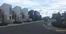
Near the end of the 20th century, residential areas sprang up at the fringes of the area, and rural farms became lifestyle blocks. The RNZAF sold the airfield back to the NZ Government (via Housing New Zealand) in 2002, although they retain a lease on much of the airfield. Since then, Waitakere City Council, in cooperation with various stakeholders, planned the future of the area, and proceeded through the requisite steps (such as District Plan changes) to rezone the land. This process, which involved making a total of 4 square kilometres of land available for development, was expected to finish in 2007.[1] On the 1.67 km² of Crown land, about 3,000 homes were to be built (in addition to facilities such as parks and schools). Of the homes, 85% were to be privately owned, while around 15% were to be state housing social rentals financed by Housing New Zealand and dispersed throughout Hobsonville.[4]
However, the setting aside of a good portion of land for state housing was criticised as an economic mistake by Opposition leader John Key, as this would lower land and house values in Hobsonville. After election as Prime Minister in 2008, Key removed the state housing requirements from Hobsonville Point and instead introduced a 'gateway housing' scheme to help first-time home buyers.
Work on housing began in 2011 with two schools and a marine industry cluster (boat & yacht building) also planned.[5]
Demographics
| Year | Pop. | ±% p.a. |
|---|---|---|
| 2006 | 1,608 | — |
| 2013 | 1,590 | −0.16% |
| 2018 | 4,938 | +25.44% |
| Source: [6] | ||
Hobsonville, comprising the statistical areas of Hobsonville and Hobsonville Point, had a population of 4,938 at the 2018 New Zealand census, an increase of 3,348 people (210.6%) since the 2013 census, and an increase of 3,330 people (207.1%) since the 2006 census. There were 1,812 households. There were 2,367 males and 2,568 females, giving a sex ratio of 0.92 males per female, with 1,029 people (20.8%) aged under 15 years, 894 (18.1%) aged 15 to 29, 2,346 (47.5%) aged 30 to 64, and 669 (13.5%) aged 65 or older.
Ethnicities were 69.3% European/Pākehā, 5.4% Māori, 2.9% Pacific peoples, 28.2% Asian, and 3.5% other ethnicities (totals add to more than 100% since people could identify with multiple ethnicities).
The proportion of people born overseas was 41.3%, compared with 27.1% nationally.
Although some people objected to giving their religion, 55.4% had no religion, 34.4% were Christian, and 5.2% had other religions.
Of those at least 15 years old, 1,593 (40.8%) people had a bachelor or higher degree, and 339 (8.7%) people had no formal qualifications. The employment status of those at least 15 was that 2,295 (58.7%) people were employed full-time, 459 (11.7%) were part-time, and 102 (2.6%) were unemployed.[6]
Economy
An area of 0.2 km² on Hobsonville Peninsula is to become a 'Marine Industry Cluster' for shipbuilding. A super yacht builder is already occupying part of the headland, and it is hoped that this will become the nucleus of a local industry to provide up to 3,000 jobs.[1] However, a later article in The New Zealand Herald stated that only 1,000 are expected to be created, though it also notes that in the meantime, three more boat building companies have already taken up residence in former aircraft hangars and old RNZAF buildings. The Marine Industry Association is pushing for the 'Marine Industry Cluster' zone change to safeguard these industries and allow further expansion.[7]
Education
Hobsonville has three schools, two primary and one secondary:
- Hobsonville School is a state full primary (Year 1–8) school with a roll of approximately 606 students.
- Hobsonville Point Primary School is a state full primary (Year 1–8) school with a roll of approximately 757 students. Opened in February 2013, it was the first school in New Zealand constructed under a public–private partnership, with the school buildings constructed and managed by a private consortium.
- Hobsonville Point Secondary School is a state secondary (Year 9–13) school with a roll of approximately 709 students. Opened in February 2014, the school initially served only Year 9, adding years as the 2014 Year 9 cohort moved through. Like its primary counterpart, the school was constructed under a public–private partnership.
All these schools are coeducational. Rolls are as at March 2020.[8]
Transportation
The Upper Harbour Motorway, connecting the Greenhithe bridge to the end of the Northwestern Motorway, was completed in August 2011, thus taking a considerable amount of through traffic away from the main local road. As part of the Western Ring Route the motorway is intended to provide a faster link from the West to the North Auckland region.[9]
On 4 February 2013 a ferry service to downtown Auckland is due to start from a newly constructed terminal on Hobsonville Point. Initially the service will offer morning and evening commuter services only with an expected travel time of 30 minutes to and from Auckland.[10] The suburb is served by three bus routes: 112, 114 and 120.[11]
Tornadoes
In December 2012, a tornado swept through west Auckland, killing three people including two who died when concrete tilt slabs fell on a transport truck at a Hobsonville construction site. The tornado also damaged 150 homes. The centre of the tornado passed over a school being built at Hobsonville Point and tore off roofs in RNZAF housing.[12]
RNZAF emergency response was activated, which included Base Medical staff, RNZAF Security Forces, NZDF Military Police, RNZAF Rescue Fire, and the RNZAF Civil Defence Response Group. The NZ Fire Service and NZ Police were also activated post–tornado.
References
- Hobsonville Archived 7 January 2007 at the Wayback Machine (from the Waitakere City Council website)
- "Land Information New Zealand – Hobsonville Place Name Proposal Report". Archived from the original on 14 February 2013. Retrieved 27 January 2013.
- https://natlib.govt.nz/records/22574552
- Frequently Asked Questions (from the Hobsonville Land Company Limited website)
- "A ferry good service". Western Leader. 21 July 2011. Retrieved 21 July 2011.
- "Statistical area 1 dataset for 2018 Census". Statistics New Zealand. March 2020. Hobsonville (119200) and Hobsonville Point (120200). 2018 Census place summary: Hobsonville 2018 Census place summary: Hobsonville Point
- Thompson, Wayne (16 March 2007). "Boat builders eye 1000 jobs". The New Zealand Herald. p. A13. Retrieved 3 October 2011.
- "New Zealand Schools Directory". New Zealand Ministry of Education. Retrieved 26 April 2020.
- New Hobsonville motorway begins construction Archived 26 May 2010 at the Wayback Machine – New Zealand Construction News, Accessed 14 November 2008
- Auckland Transport – Hobsonville ferry terminal Archived 8 February 2013 at the Wayback Machine
- "West Auckland Network Map" (PDF). Auckland Transport. Retrieved 17 May 2018.
- "Auckland tornado kills 3, hits 150 homes". Stuff.co.nz. 6 December 2012. Retrieved 4 April 2017.
External links
- Hobsonville (Waitakere City Council website)
- Hobsonville Land Company Limited (a Housing New Zealand subsidiary)
- Photographs of Hobsonville held in Auckland Libraries' heritage collections.