Waitematā Harbour
Waitematā Harbour is the main access by sea to Auckland, New Zealand. For this reason it is often referred to as Auckland Harbour, despite the fact that it is one of two harbours adjoining the city. The harbour forms the northern and eastern coasts of the Auckland isthmus and is crossed by the Auckland Harbour Bridge. It is matched on the southern side of the city by the shallower waters of the Manukau Harbour.


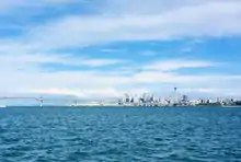
With an area of 70 square miles (180 km2),[1] it connects the city's main port and the Auckland waterfront to the Hauraki Gulf and the Pacific Ocean. It is sheltered from Pacific storms by Auckland's North Shore, Rangitoto Island, and Waiheke Island.
Etymology
The oldest Māori name of the harbour was Te Whanga-nui o Toi (The Big Bay of Toi), named after Toi, an early Māori explorer.[2]
The name Waitematā means "Te Mata Waters", and refers to Te Mata (Boat Rock), which lies in mid-harbour off Kauri Point.[2] A popular translation of Waitematā is "The Obsidian Waters", referring to obsidian rock (matā). Another popular translation, derived from this, is "The Sparkling Waters", as the harbour waters were said to glint like the volcanic glass obsidian.[3] However, this is incorrect,[4] as grammatically Waitematā could not mean this.[2]
Geography
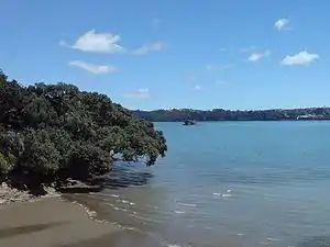
The harbour is an arm of the Hauraki Gulf, extending west for eighteen kilometres from the end of the Rangitoto Channel. Its entrance is between North Head and Bastion Point in the south. The westernmost ends of the harbour extend past Whenuapai in the northwest, and to Te Atatū in the west, as well as forming the estuarial arm known as the Whau River in the southwest.
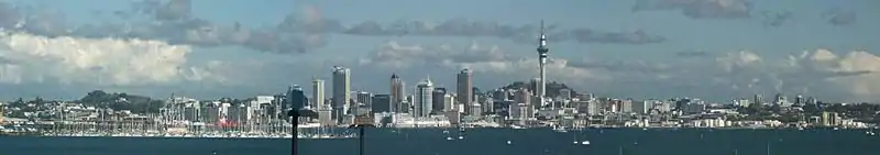
The northern shore of the harbour consists of North Shore. North Shore suburbs located closest to the shoreline include Birkenhead, Northcote and Devonport (west to east). On the southern side of the harbour is Auckland CBD and the Auckland waterfront, and coastal suburbs such as Mission Bay, Parnell, Herne Bay and Point Chevalier (east to west), the latter of which lies on a short triangular peninsula jutting into the harbour.
The harbour is crossed at its narrowest point by the Auckland Harbour Bridge. To the east of the bridge's southern end lie the marinas of Westhaven and the suburbs of Freemans Bay and the Viaduct Basin. Further east from these, and close to the harbour's entrance, lies the Port of Auckland.
There are other wharves and ports within the harbour, notable among them the Devonport Naval Base, and the accompanying Kauri Point Armament Depot at Birkenhead, and the Chelsea Sugar Refinery wharf, all capable of taking ships over 500 gross register tons (GRT). Smaller wharves at Birkenhead, Beach Haven, Northcote, Devonport and West Harbour offer commuter ferry services to the Auckland CBD.

Geology
The harbour is a drowned valley system that was carved through Miocene marine sediments of the Waitemata Group. Recent volcanism in the Auckland volcanic field has also shaped the coast, most obviously at Devonport and the Meola Reef (a lava flow which almost spans the harbour), but also in the explosion craters of Orakei Basin and in western Shoal Bay. In periods of low sea level, a tributary ran from Milford into the Shoal Bay stream. This valley provided the harbour with a second entrance when sea levels rose, until the Lake Pupuke volcano plugged this gap.[5]
The current shore is strongly influenced by tidal rivers, particularly in the west and north of the harbour. Mudflats covered by mangroves flourish in these conditions, and salt marshes are also typical.[1]

History
.jpg.webp)
The harbour has long been the main anchorage and port area for the Auckland region, even before European colonial times. Well-sheltered not only by the Hauraki Gulf itself but also by Rangitoto Island, the harbour offered good protection in almost all winds, and lacked dangerous shoals or major sand bars (like on the Manukau Harbour) that would have made entry difficult. The harbour also proved a fertile area for encroaching development, with major land reclamation undertaken, especially along the Auckland waterfront, within a few decades of the city's European founding.[6]
Taking the idea of the several Māori portage paths over the isthmus one step further, the creation of a canal that would link the Waitematā and Manukau harbours was considered in the early 1900s. Legislation (the Auckland and Manukau Canal Act 1908) was passed that would allow authorities to take privately owned land where it was deemed required for a canal. However, no serious work (or land take) was undertaken. The act was repealed on 1 November 2010.[7]
Sewage contamination
While the harbour has numerous beaches popular for swimming, the older-style "combined sewers" in several surrounding western suburbs dump contaminated wastewater overflows into the harbour on approximately 52 heavy-rain days a year, leading to regular health warnings at popular swimming beaches, until the outfalls have dispersed again. A major new project, the Central Interceptor, starting 2019, is to reduce these outfalls by about 80% once completed around 2024.[8]
Demographics
| Year | Pop. | ±% p.a. |
|---|---|---|
| 2006 | 21 | — |
| 2013 | 24 | +1.93% |
| 2018 | 84 | +28.47% |
| Source: [9] | ||
The statistical area of Inlet Waitemata Harbour had a population of 84 at the 2018 New Zealand census, an increase of 60 people (250.0%) since the 2013 census, and an increase of 63 people (300.0%) since the 2006 census. There were no households. There were 60 males and 21 females, giving a sex ratio of 2.86 males per female. The median age was 25.5 years, with no people aged under 15 years, 54 (64.3%) aged 15 to 29, 21 (25.0%) aged 30 to 64, and 9 (10.7%) aged 65 or older.
Ethnicities were 50.0% European/Pākehā, 10.7% Māori, 3.6% Pacific peoples, 39.3% Asian, and no other ethnicities (totals add to more than 100% since people could identify with multiple ethnicities).
The proportion of people born overseas was 57.1%, compared with 27.1% nationally.
Although some people objected to giving their religion, 39.3% had no religion, 50.0% were Christian, and 3.6% had other religions.
Of those at least 15 years old, 9 (10.7%) people had a bachelor or higher degree, and 3 (3.6%) people had no formal qualifications. The median income was $40,200. The employment status of those at least 15 was that 54 (64.3%) people were employed full-time, 6 (7.1%) were part-time, and 0 (0.0%) were unemployed.[9]
References
- Waterhouse, Barry Clayton (1966). "Waitemata Harbour". In McLintock, A. H. (ed.). An Encyclopaedia of New Zealand – via Te Ara – the Encyclopedia of New Zealand.
- Nepia, E. (28 November 1931). "Waitemata: meaning and history: a popular error". Auckland Star. p. 12 Supplement. Retrieved 19 November 2016.
- Information plaque at the end of Princes Wharf (as of 2007).
- Graham, George (1979). "Maori place names". Records of the Auckland Institute and Museum. 16: 4.
Wai-te-mata means the 'Flint stone waters'. Te Mata is 'The flint stone' – is a pinnacle rock mid stream up harbour. It was formerly a tribal fishing boundary; as also a place whereon offerings were made by the fishers of their first catches, so as to propitiate the local deities, hence the name of the Harbour: 'Wai-te-mata'. It does not mean as is usually stated the 'sparkling' or 'flashing waters'.
- City of Volcanoes: A geology of Auckland - Searle, E. J., 1981, 2nd edition, revised by Mayhill, R. D. Longman Paul, Auckland. ISBN 0-582-71784-1. Figure 5.2, Page 69.
- References provided in the Auckland waterfront article.
- "Auckland and Manukau Canal Act 1908". New Zealand Legislation. 2010-11-01. Retrieved 2017-09-20.
- Tapped In (newsletter). Watercare. Autumn 2019.
- "Statistical area 1 dataset for 2018 Census". Statistics New Zealand. March 2020. Inlet Waitemata Harbour (119300). 2018 Census place summary: Inlet Waitemata Harbour
External links
| Wikimedia Commons has media related to Waitemata Harbour. |
- Photographs of Waitematā Harbour held in Auckland Libraries' heritage collections
- Photographs of Waitematā Harbour held at Auckland Museum