Hojai
Hojai is a town and a municipal board in Hojai district in the Indian state of Assam.[3]
Hojai | |
|---|---|
Town | |
 Aerial view of Hojai town | |
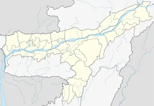 Hojai Location in Assam, India  Hojai Hojai (India) | |
| Coordinates: 26.0°N 92.87°E | |
| Country | |
| State | Assam |
| District | Hojai |
| Government | |
| • Type | Municipal |
| • Body | Hojai Municipality Board |
| • MLA | Shiladitya Dev (BJP) |
| Area | |
| • Total | 21.219 km2 (8.193 approx sq mi) |
| Population (2011)[1] | |
| • Total | 36,638 |
| • Density | 1,700/km2 (4,500/sq mi) |
| Language | |
| • Official | Assamese[2] |
| Time zone | UTC+5:30 (IST) |
| PIN | 782435 |
| Hojai STD Code | +91-3674 |
| ISO 3166 code | IN-AS |
| Vehicle registration | AS 31 |
| HDI | |
| Effective literacy | 90.7% |
| Climate | Cwa (Köppen) |
| Website | hojai |
Etymology
The word Hojai is derived from one clan of Dimasa people, who populated the settlement during its initial formation.
Geography
Hojai is located at 26.0°N 92.87°E.[4] It has an average elevation of 59 metres (193 feet).
History
Hojai was a part of Dimasa Kachari Kingdom in medieval times. The Dimasa Kacharies living in Hojai are known as "Hojai-Kacharies" to others. "Hojai" is one of the clans (Sengphongs) of Dimasa tribe, probably The city "Hojai" got its name from this clan. It was made a sub-division on 15 August 1983 under Nagaon district. On 15 August 2016, it was declared a new district of the state along with 3 other new districts.[5]
Demographics
As of 2011 Indian Census, Hojai had a total population of 36,638, of which 18,762 were males and 17,876 were females. Population within the age group of 0 to 6 years was 3,869. The total number of literates in Hojai was 29,708, which constituted 81.1% of the population with male literacy of 83.9% and female literacy of 78.1%. The effective literacy rate of 7+ population of Hojai was 90.7%, of which male literacy rate was 93.8% and female literacy rate was 87.4%. The Scheduled Castes and Scheduled Tribes population was 3,158 and 197, respectively. Hojai had 7049 households in 2011.[1]
Language
69.6% of the people speak Bengali, followed by Hindi, 16.0%; Assamese, 10.7%; and Meitei, 1.6% speakers.[6]
Religion
Most of the population follow Hinduism (81.11%), with Islam being the largest minority religion with 18.28% adherents. Sikhism, Christianity and other religions are followed by less than one per cent of the population.[7]
Administration
Hojai is an MLA constituency. It falls under Nagaon LS constituency. It was part of Jamunamukh LAC. Since its inception in 1967, seven people were elected as MLAs. The first was Jonab Rahimuddin Ahmed. He was followed by Idris Ali Fakir, Sadhan Ranjan Sarkar, Santi Ranjan Dasgupta and since 1991, Dr AK Dey has been consistently elected as an MLA, the lone defeat coming in 2006 to AIUDF's Aditya Langthasa who served as an MLA for a single term. Dr Dey regained his seat in 2011 for a fourth term. For the first time, in 2016 assembly elections, BJP wrested this seat with the incumbent MLA being Shiladitya Dev.
Administrative duties are carried on from Sankardev Nagar in NH27 (earlier NH54) where the DC Office, Judicial Courts as well District SP Offices are located. The DC Office campus also houses the Government Circuit House within it. Hojai Judicial Courts are situated at Sankardev Nagar approximately 8 km away from Hojai Town near NH27 (earlier NH54). Advocates of the Hojai Judicial Courts have their own Association known as "Hojai Bar Association" which was established in 1982.
Education
Hojai College, affiliated to Gauhati University was established in the year 1964. On 26 July 2016, Assam's Chief Minister Sarbananda Sonowal proposed a university be set up in Hojai and named after Rabindra Nath Tagore.
Healthcare
Haji Abdul Majid Memorial Hospital (HAMM) and Research Centre
The Haji Abdul Majid Memorial Hospital(HAMM) and Research Center is a 200-bed hospital, one of the largest rural charitable hospitals in South East Asia. Inaugurated in 1995 by the late Reverend St. Mother Teresa, it offers free treatment to the poor. Its charitable dispensary, established in 1986, treats over ten patients for free every day. Till date, over 25 lakh people without distinction of caste, creed or religion have benefited from the free medication. Finally, the Haji Abdul Majid Memorial Hospital & Research Centre will become a full-fledged medical college.
The hospital has an operating theatre. The hospital also has a dental clinic, which is a boon in an area with widespread dental problems due to lack of hygiene and sanitation.
Transport
Road


State roads connect Hojai to the rest of the state. The nearest National Highway is NH54. Buses connect Hojai to the rest of Assam and other states. There is a proposed flyover in Hojai.
Railway
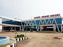
The Hojai railway station lies on the Guwahati–Lumding section line of the Lumding division. The station provides railway connectivity to different cities of India through many long distance trains.
Airport
The nearest airport is Tezpur Airport, about 120 km away.
The nearest International Airport is LGB[10] International Airport in Guwahati, about 190 km away.
References
- "Census of India: Hojai". www.censusindia.gov.in. Retrieved 14 January 2020.
- "52nd REPORT OF THE COMMISSIONER FOR LINGUISTIC MINORITIES IN INDIA" (PDF). nclm.nic.in. Ministry of Minority Affairs. Archived from the original (PDF) on 25 May 2017. Retrieved 14 January 2020.
- "Assam gets five more districts". Zee News. 15 August 2015.
- "redirect to /world/IN/03/Hojai.html". www.fallingrain.com.
- "Know about the District | Hojai District | Government Of Assam, India". hojai.assam.gov.in.
- "C-16 Population By Mother Tongue - Hojai (MB)". census.gov.in. Retrieved 14 January 2020.
- "C-16 Population By Religion - Assam". census.gov.in. Retrieved 16 August 2020.
- "Meet the Deputy Commissioner | Hojai District | Government Of Assam, India". Retrieved 17 March 2020.
- "Ankur Jain, IPS | Hojai District | Government Of Assam, India". hojai.assam.gov.in. Retrieved 4 February 2020.
- "Guwahati Airport". aera.gov.in. Retrieved 10 July 2018.
