Hojai district
Hojai District is a district in Assam, India. It was formed on 15 August 2015.[1] The headquarters of the District is situated at Sankardev Nagar, which is about 8 km away from Hojai town. Hojai District was formed from three tehsils of Nagaon District, namely Hojai, Doboka and Lanka. Hojai was a part of undivided Nowgong district (now Nagaon) of then Assam Province.
Hojai district | |
|---|---|
District of Assam | |
 | |
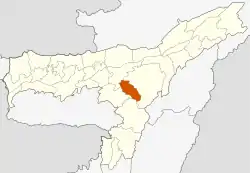 Location of Hojai district in Assam | |
| Coordinates (Hojai): 26.0°N 92.87°E | |
| Country | |
| State | Assam |
| Headquarters | Sankardev Nagar, Hojai |
| Tehsils | 3 |
| Government | |
| • Lok Sabha constituencies | Nowgong |
| • Vidhan Sabha constituencies | Hojai, Jamunamukh, Lumding |
| Population (2011) | |
| • Total | 931,218 |
| Time zone | UTC+05:30 (IST) |
| Official language | Assamese |
| Most Spoken language | Sylheti |
| Website | hojai |
History
The geographical area presently under Hojai district and its surrounding area as in the history of the ancient Kamarupa, was known as Davaka kingdom or Kapili Valley kingdom. In different sources this kingdom is mentioned as ‘Dabak’, ‘Kapili’ and ‘Tribeg’. This kingdom enjoyed independent status up to the 6th century CE.[2]
Medieval historical sources mention that during the reign of Kashyap (1365-1400) of the Barahi Pala dynasty there began a new era of Kachari supremacy in the Kapili-Jamuna valley. Birochana, a minister of Kachari origin in the service of king Bhoumapala of Behali area in the north bank of Brahmaputra had to flee his kingdom after a conflict with the king and came to the south bank of Brahmaputra and established a new kingdom on the banks of the Kalong river which was Brahmapur or the present day Batampur and he assumed the name ‘Bicharpatipha’. Soon Kachari reign spread to the entire Kapili-Jamuna valley and the name of the kingdom was known as Kacharipar.
Due to Ahoms kingdom's vigorous territorial expansion, the Kachari kings came in to conflict with them. During the rule of Kachari king Tamradhwaja Narayan the Kachari ruled areas went to the Ahoms under Swargadeo Gadadhar Singha.
The word ‘Hojai’ is of Dimasa origin. The priestly class of the Dimasas is known as Hoja or Hojaisa and the place they inhabited came to be known as Hojai. Even now Hojai area has a sizeable population of Dimasas and some of them have the surname ‘Hojai’.
Demographics
According to the Indian Census of 2011, the three tehsils in the newly formed Hojai District had a population of 931,218 in 2011. Among those 499,565 are Muslim and 424,065 are Hindu, constitutuing 53.65% and 45.53% of district population respectively.
After Sylhet referendum which led to separation of Sylhet division from then Assam Province, a large number of Bengali Hindus have migrated to the area from the then East Pakistan and are mostly settled in the towns such as Lumding, Lanka and Hojai.

| Tehsil | Total | Hindu | Muslim | Hindu % | Muslim % |
|---|---|---|---|---|---|
| Hojai | 228,530 | 135,377 | 92,590 | 59.24% | 40.52% |
| Dabaka | 303,767 | 37,872 | 265,366 | 12.47% | 87.35% |
| Lanka | 398,921 | 250,816 | 141,609 | 62.87% | 35.50% |
| Total (2011) | 931,218 | 424,065 | 499,565 | 45.53% | 53.65% |
Politics
Hojai district has three assembly constituencies. They are Jamunamukh, Hojai and Lumding. Hojai district is also part of Nowgong constituency.
References
- "Assam gets new district of Hojai" Archived 1 July 2016 at the Wayback Machine, The Northeast Today
- https://hojai.assam.gov.in/frontimpotentdata/history-of-hojai-0
- Indian Census of 2011
- "C-16 Population By Mother Tongue - Assam". censusindia.gov.in. Retrieved 12 April 2020.