Horní Planá
Horní Planá ([ˈɦorɲiː ˈplanaː] (![]() listen), German: Oberplan) is a town in Český Krumlov District in the South Bohemian Region of the Czech Republic. It has about 2,100 inhabitants.
listen), German: Oberplan) is a town in Český Krumlov District in the South Bohemian Region of the Czech Republic. It has about 2,100 inhabitants.
Horní Planá | |
|---|---|
Town | |
 View from Lipno reservoir | |
 Flag  Coat of arms | |
 Horní Planá Location in the Czech Republic | |
| Coordinates: 48°46′3″N 14°1′57″E | |
| Country | |
| Region | South Bohemian |
| District | Český Krumlov |
| First mentioned | 1349 |
| Government | |
| • Mayor | Jiří Hůlka |
| Area | |
| • Total | 99.26 km2 (38.32 sq mi) |
| Elevation | 776 m (2,546 ft) |
| Population (2020-01-01[1]) | |
| • Total | 2,080 |
| • Density | 21/km2 (54/sq mi) |
| Time zone | UTC+1 (CET) |
| • Summer (DST) | UTC+2 (CEST) |
| Postal code | 382 26 |
| Website | www |
Geography
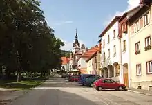
The town is situated in the Bohemian Forest on the southeastern rim of the Šumava National Park, located on the northern shore of the Lipno Reservoir, south of the Boletice Military Training Area. Its picturesque setting, already perpetuated by the native poet Adalbert Stifter (1805–1868), makes it a popular destination for daytrippers. Beyond the Lipno reservoir, a densely forested area with several abandoned villages stretches up to the Vltava-Danube drainage divide (part of the main European Watershed) and the border with Austria at a distance of about 7 km (4 mi).
History
Horní Planá was part of the estates of Zlatá Koruna Abbey, founded by the Přemyslid king Ottokar II in 1263. It was vested with market rights by King Charles IV in 1349. Secularised during the Hussite Wars in 1420, it was incorporated into the Lordship of Český Krumlov, then held by the House of Rosenberg. The Rosenberg insignia were adopted in the town's coat of arms, awarded by the Holy Roman emperor and King of Bohemia Maximilian II in 1568.
The town received access to the United Bohemian Forest railway line from České Budějovice to the Černý Kříž railhub in 1892. Until 1945 the local population predominantly consisted of Sudeten Germans.
In October 1938, the Donau-Zeitung reported about the German Oberst Schlemmer and his Gebirgsjägerregiment 100 crossing into Glöckelberg, six km from Oberplan. Shortly before 2 pm, Generaloberst Leeb, commander of XIII. Armeekorps, and Ritter von Schubert, commander of VII Armeekorps, arrived by car to cross the border right in front of these men.[2] Oberplan was annexed by Nazi Germany upon the 1938 Munich Agreement and incorporated into the Reichsgau Oberdonau.
In May 1945, US troops under command of Major General Stafford LeRoy Irwin captured the community.[3] After World War II, it was restored to the Czechoslovak Republic, while the remaining German population was expelled.
Notable people
- Adolf Martin Pleischl (1787–1867), chemist and medical doctor
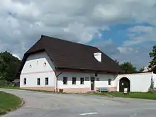
- Adalbert Stifter (1805–1868), writer, poet, painter and pedagogue
References
- "Population of Municipalities – 1 January 2020". Czech Statistical Office. 2020-04-30.
- Anna Rosmus Hitlers Nibelungen, Samples Grafenau 2015, p. 185
- Anna Rosmus Hitlers Nibelungen, Samples Grafenau 2015, p. 185
External links
 Media related to Horní Planá at Wikimedia Commons
- (in Czech) Official website
| Authority control |
|---|