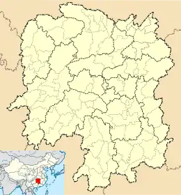
Huarong County
Huarong County (simplified Chinese: 华容县; traditional Chinese: 華容縣; pinyin: Huáróng Xiàn) is a county in Hunan province, China, it is under the administration of Yueyang City.
Huarong County
华容县 Hwajung | |
|---|---|
 Huarong Location of the seat in Hunan | |
| Coordinates: 29°29′10″N 112°40′23″E | |
| Country | People's Republic of China |
| Province | Hunan |
| Prefecture-level city | Yueyang |
| Seat | Zhanghua |
| Time zone | UTC+8 (China Standard) |
The county is located on the northeastern margin of the province, on the southern bank of the Yangtze River and on the northern bank of the Dongting Lake. Huarong County is bordered to the east and the southeast by Junshan District, to the southwest by Nanxian and Anxiang Counties, to the north by Shishou City of Hubei, to the northeast by Jianli County of Hubei.
The county covers an area of 1,593 km2 (615 sq mi), as of 2015, it had a registered population of 723,800 and a permanent resident population of 725,600.[1] The county has 12 towns and 2 townships under its jurisdiction. The government seat is Zhanghua Town (章华镇).[2]
Administrative divisions
According to the result on adjustment of township-level administrative divisions of Huarong county on November 20, 2015, Huarong has 12 towns and 2 townships under its jurisdiction.[2] they are:
2 townships
- Tuanzhou (团洲乡)
- Xinhe, Huarong (新河乡)
12 towns
- Beijinggang (北景港镇)
- Caojun (操军镇)
- Chaqi (插旗镇)
- Dongshan, Huarong (东山镇)
- Meitianhu (梅田湖镇)
- Nianyuxu (鲇鱼须镇)
- Sanfengsi (三封寺镇)
- Wanyu, Huarong (万庾镇)
- Yushan, Huarong (禹山镇)
- Zhanghua Town (章华镇)
- Zhihedu (治河渡镇)
- Zhuzikou (注滋口镇)
Climate
| Climate data for Huarong (1981−2010) | |||||||||||||
|---|---|---|---|---|---|---|---|---|---|---|---|---|---|
| Month | Jan | Feb | Mar | Apr | May | Jun | Jul | Aug | Sep | Oct | Nov | Dec | Year |
| Record high °C (°F) | 22.4 (72.3) |
28.4 (83.1) |
32.1 (89.8) |
35.3 (95.5) |
35.3 (95.5) |
37.9 (100.2) |
39.3 (102.7) |
39.7 (103.5) |
37.3 (99.1) |
33.5 (92.3) |
30.1 (86.2) |
23.0 (73.4) |
39.7 (103.5) |
| Average high °C (°F) | 8.3 (46.9) |
10.7 (51.3) |
15.0 (59.0) |
21.7 (71.1) |
26.8 (80.2) |
29.9 (85.8) |
32.9 (91.2) |
32.2 (90.0) |
28.2 (82.8) |
22.8 (73.0) |
17.1 (62.8) |
11.1 (52.0) |
21.4 (70.5) |
| Daily mean °C (°F) | 4.6 (40.3) |
6.9 (44.4) |
11.0 (51.8) |
17.3 (63.1) |
22.4 (72.3) |
25.9 (78.6) |
28.9 (84.0) |
28.2 (82.8) |
23.8 (74.8) |
18.3 (64.9) |
12.5 (54.5) |
6.9 (44.4) |
17.2 (63.0) |
| Average low °C (°F) | 1.9 (35.4) |
4.2 (39.6) |
7.9 (46.2) |
13.9 (57.0) |
18.9 (66.0) |
22.7 (72.9) |
25.8 (78.4) |
25.1 (77.2) |
20.6 (69.1) |
15.1 (59.2) |
9.3 (48.7) |
4.0 (39.2) |
14.1 (57.4) |
| Record low °C (°F) | −8.4 (16.9) |
−4.6 (23.7) |
−1.3 (29.7) |
2.5 (36.5) |
10.0 (50.0) |
13.5 (56.3) |
19.4 (66.9) |
16.8 (62.2) |
10.9 (51.6) |
3.4 (38.1) |
−1.2 (29.8) |
−6.5 (20.3) |
−8.4 (16.9) |
| Average precipitation mm (inches) | 55.5 (2.19) |
75.2 (2.96) |
103.9 (4.09) |
157.4 (6.20) |
161.3 (6.35) |
193.9 (7.63) |
172.6 (6.80) |
131.0 (5.16) |
61.7 (2.43) |
82.0 (3.23) |
73.0 (2.87) |
37.1 (1.46) |
1,304.6 (51.37) |
| Average relative humidity (%) | 79 | 79 | 79 | 79 | 78 | 80 | 79 | 80 | 78 | 78 | 76 | 75 | 78 |
| Source: China Meteorological Data Service Center[3] | |||||||||||||
References
- the population of Huarong County in 2015, according to the Statistical Communiqué of Huarong County on the 2015 National Economic and Social Development - (2015年华容县国民经济和社会发展统计公报): yueyang.gov or huarong.gov
- the divisions of Huarong County in 2015, according to the result on adjustment of township-level administrative divisions of Huarong County on (November 20, 2015) - 《湖南省民政厅关于同意华容县乡镇区划调整方案的批复》(湘民行发〔2015〕60号): rednet (20-Nov-15) or hrnews.cn, also see people.com : 湖南省乡镇区划调整改革109个县市区批复方案 (2015-12-08) or xinhuanet.com
- "中国地面气候标准值月值(1981-2010)" (in Chinese). China Meteorological Data Service Center. Retrieved 20 October 2018.
