Hudlice
Hudlice is a municipality and village in Beroun District in the Central Bohemian Region of the Czech Republic. It has about 1,200 inhabitants. The municipality consists of Hudlice village and hamlets of Lísek, Varta and Doužebnice.
Hudlice | |
|---|---|
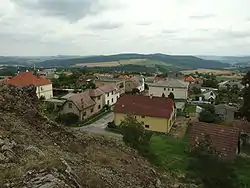 General view of Hudlice | |
 Flag  Coat of arms | |
 Hudlice Location in the Czech Republic | |
| Coordinates: 49°57′40″N 13°58′15″E | |
| Country | |
| Region | Central Bohemian |
| District | Beroun |
| Founded | 1341 |
| Area | |
| • Total | 20.73 km2 (8.00 sq mi) |
| Elevation | 401 m (1,316 ft) |
| Population (2020-01-01[1]) | |
| • Total | 1,225 |
| • Density | 59/km2 (150/sq mi) |
| Time zone | UTC+1 (CET) |
| • Summer (DST) | UTC+2 (CEST) |
| Postal code | 267 03 |
| Website | www |
Geography
Hudlice is situated in steep slope of the Krušná Hora mountain, a part of Křivoklátská vrchovina hills. Historical part of the village follows unnamed creek, the right tributary of Libotický potok.
St. Thomas Church, village hall and school is situated here. A neighbourhood Pod Skálou was established in second half of 20 the century, located close to local dominant – isolated prominent cliff named Hudlická skála. In ravine of unnamed creek, shacks were erected during Great Depression, later rebuilt to ordinary houses.
A wastewater treatment plant is situated at the west end of the neighbourhood.
Number of houses is growing in 21st century, concentrated in plateaus of Hořejší and Dolejší.
Third class road connects the village with the town Králův Dvůr. Other third class roads lead to Karlov, Kublov, and Otročiněves. A local road connects Hudlice with Zdejcina, a part of Beroun, taking place on mountain ridge of Kozlí Hora, leading through a former military base.
Hudlice municipality administers several settlements and hamlets, as well as a top of the Krušná hora mountain where tourist look-out tower Máminka is situated.
Waters
Hudlice is drained by three creeks. A water mill Dibří was built on its confluence. Dibeřský potok is the creek with the highest flow, flowing through Běstiny ravine, where Hudlice water source is placed. The Dibeřský potok creek originates in Svatá municipality, in a place called U zeleného kříže.
All waters flows to Litavka river, or Elbe river via Berounka river, situated in North Sea basin.
Libotický potok creek originates at north part of Hudlice, bypasses the village at the west, feeds three ponds, bypasses Kozlí hora mountain and flows into Dibřeský potok in the area of Dibří.
Unnamed creek, mostly canalized, flowing through center of the village, goes to deep ravine and mouthing to Libotický potok near wastewater treatment plant.
Mountains
The highest peak in Krušná Hora (609 meters above sea level), the lowest point is a confluence of three creeks in Dibří (275 meters above sea level). Hudlická skála (475 meters above sea level) an isolated cobblestone cliff and Kozlí skála (381 above sea level) are significant points.
Hudlice isolated settlements and hamlets
- Lísek – a settlement established during Thirty Years' War without permission. Situated on a border of former Křivoklát manor and Nižbor court was a source of conflicts, joined to Křivoklát manor lately by The Bohemian Chamber. Low quality stone coal was mined, after its depletion a production of sulfuric acid was established. In 21st century Lísek is a recreational area with 10 residents, pension and Quarter horse breeding.
- Dibří – former water mill, later evolved in recreational area with cabins.
- Stará ves – ruins of Újezd village, destroyed in Hussite Wars. Protected area with endangered species of plants and butterflies.
- Doužebnice – small village, mostly removed because of iron ore mining. Forester log has been preserved.
- Varta – a hamlet, hunter cabin.
- Trnovka – recreational area with cabins.
- Gabriela Mine – former mine.
Local places
- Na Úmrlčí – crossroad of private road heading to Svatá village and a public road to Kublov. A place where funeral processions were started, as its reflected in its name ("Na Úmrlčí" means "on the dead side").
- Pyramida – mountain pass. Steep unpaved road resembles a side of a pyramid, what inspired its name.
- Tichina – rocky plateau situate above Běstiny ravine, place of municipal landfill.
- Běstiny – deep, swampy ravine, water source for the municipality.
- Pod Skálou – neighbourhood of the isolated rock of Hudlická skála.
- Loužek – dried swamp located between Hudlice village and Varta hamlet.
- Chaloupky – former houses of charcoals producers, situated at east side of the village.
History
[2] Václav Hájek z Libočan writes in his chronicle the village was gifted by duke Jaromír to his servant Hovora. This story is considered as a romantical fabulation. Strong evidence of a village origin is a letter from 1341. King John of Luxembourg allows to Jindřich of Provendorf and Pešek Benešovský to establish a village in place called Hudlice. Thus, a place named Hudlice existed before village, meaning "to whizz" in old Czech, obviously referring to local strong winds. Historical name of village were also "Udlice" or "Udlitz".
Another ancient note comes from 1379. In a church letter, parson from Počaply makes note about excommunication of Hudlice resident named Malsa.
Hudlice was part of Karlštejn manor until 1558, later transferred to Křivoklát manor.
Local residents was making living by producing charcoal, by mining iron ore and vermilion.
An isolated settlement was established to mining tin, the settlement later evolved to Svatá village. Tin miners were subordinate by exception to Točník manor. The manor was paying a fee to Hudlice until 1557, when fees were stopped by Jan Lobkowitz. Hudlice made complain to Bohemian king Rudolph II of Austria who decided to the favor of Hudlice, however Jan Lobkowitz did not respect king decision and fees was not renewed even by his son Ladislav Lobkowitz. The dispute was terminated when Ladislav Lobkowitz sentenced to death for high treason by Rudolph II of Austria, escaped to Germany. The tin mines were abandoned as well as Svatá village, except two houses.
During Hussite Wars, Hudlice was heavily damaged by both Hussite and Catholic forces. In nearby stronghold Křivoklát, royal gold was stored as well as it was shelter for Bohemian nobility. The Křivoklát was besieged several times for this reasons and Hudlice was looted. Hudlice noble man Buzek ze Tmaně na Hudlicích was notable hero of Hussite Wars, member of Karlštejn garrison when the castle was besieged for half year; later known for his elimination of Hussite bandit Zákon z Ostroměče. Buzek killed him together with his eleven soldiers in a fight near Mníšek pod Brdy. Hudlice, nearly erased, was renewed by letter of Karlštejn manor. Buzek erected small stronghold, using allocated resources from the letter. The stronghold, situated in U Panské zdi street, was later reconstructed to family house.
Hudlice was heavily damaged in a time before Thirty Years' War. The village was looted by mercenaries called by King Frederick V. Frederick V allowed villagers to catch soldiers and even making death sentences. Later, this attitude was not tolerated and punitive expedition was performed from Křivoklát Castle. Hudlice was looted by several armies of Mansfeld, Buquoy, Thurn and Wallenstein. Twenty-two houses from the total count of 31 was destroyed.
In 1685, Hudlice was in possessions of Wallenstein noble family, who opened iron mines. Mining was shortly stopped by high level of groundwater what was unsolvable complication for this time technology.
Expansion of iron mining happened in 1731, when Hudlice was owned by the Fürstenberg family. Village population rose by numbers of workers coming from abroad. In a group of foreign workers was also a Jungmann family, whose sons were Josef Jungmann, the author of modern Czech vocabulary and Josef Jan Jungmann, founder of Czech obstetrics. Jungmann family house is kept as a national monument.
St. Thomas church was erected in 1876.
After World War I iron ore mining was interrupted except for quartzite mining, stone was used to build new highway Prague – Plzeň. Iron ore mining was renewed in 1924, opening new site Gabriela Mine. During World War II was built cableway, transporting iron ore to Králův Dvůr smeltery. In the end of World War I improvised Vlasov Army headquarters was placed in mines, bombarded by Germans. Air raid did not damage houses.
After World War II mines were nationalized by decree of Edvard Beneš. After communist coup d'état of 1948, it was decided to multiply iron ore production, ideally reaching national national self-sufficiency. Land was made available to incoming miners to erect family houses.
Mine rentability decreased rapidly and the mine was closed in 1967.
Soviet invasion in 1968 did not damage village in any way. Military base was erected on the border of Hudlice hamlet Lísek. After Velvet Revolution population decreased to half. In 2014 new look-put tower Máminka was opened. In 21st century, population is slowly growing, as Hudlice, situated near city of Prague is sought for housing.
Economy and transport
Hudlice is connected by public bus line with Beroun. No significant industry is situated in area. Municipality is popular tourist locality for preserved hunting forests of former Křivoklát manor.
Tourism
Popular tourist attractions are Hudlická skála, Josef Jungmann Museum and abandoned iron ore mine Gabriela.
Notable residents
- Josef Jungmann (1773–1847), poet and linguist
References
- "Population of Municipalities – 1 January 2020". Czech Statistical Office. 2020-04-30.
- Václav Kočka: Dějiny Rakovnicka, ISBN 978-80-85081-28-2, Agroscience ve spolupráci s Musejním spolkem královského města Rakovníka a okresu rakovnického a Muzeem T.G.M. Rakovník
| Wikimedia Commons has media related to Hudlice. |
| Authority control |
|
|---|