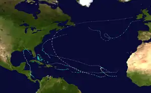
Hurricane Fred (2009)
Hurricane Fred was one of the easternmost forming major hurricanes in the North Atlantic basin since satellite observations became available. Forming out of a strong tropical wave on September 7, 2009 near the Cape Verde Islands, Fred gradually organized within an area of moderate wind shear. The following day, decreasing shear allowed the storm to intensify and develop well-organized convective banding features. Later on September 8, Fred attained hurricane intensity and underwent rapid intensification overnight, attaining its peak intensity as a strong Category 3 hurricane with winds of 120 mph (195 km/h) and a barometric pressure of 958 mbar (hPa; 28.29 inHg). Shortly after reaching this intensity, the hurricane began to weaken as wind shear increased and dry air hampered convective development.[1]
| Category 3 major hurricane (SSHWS/NWS) | |
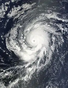 Hurricane Fred at peak intensity on September 9 | |
| Formed | September 7, 2009 |
|---|---|
| Dissipated | September 19, 2009 |
| (Remnant low after September 12) | |
| Highest winds | 1-minute sustained: 120 mph (195 km/h) |
| Lowest pressure | 958 mbar (hPa); 28.29 inHg |
| Fatalities | None reported |
| Damage | None |
| Areas affected | Cape Verde Islands |
| Part of the 2009 Atlantic hurricane season | |
Throughout September 10, Fred maintained Category 2 status before weakening to a Category 1 hurricane. Continued weakening took place on September 11 as convection became fully disorganized. Later that day, Fred weakened to a tropical storm and by September 12, no convection remained around the center of the former hurricane, leaving an exposed low-level circulation. The storm degenerated into a remnant-low later that day, corresponding with the final advisory from the National Hurricane Center (NHC). The remnants of Fred persisted for nearly a full week, traveling west-northwest across the Atlantic basin. The remnants finally dissipated on September 19. Prior to becoming a tropical depression, the precursor to Fred produced moderate to heavy rainfall in the southern Cape Verde Islands, leading to two flight cancellations and several delays.
Meteorological history
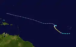
Hurricane Fred originated from a strong tropical wave that moved off the west coast of Africa on September 6. Environmental conditions ahead of the system favored development and the system was forecast to slowly develop into a tropical cyclone.[2] The following day, the wave tracked south of the Cape Verde Islands; however, it was close enough to bring showers and gusty winds to the southern islands. By this time, the National Hurricane Center anticipated the system to organize into a tropical depression within 24 hours.[3] While passing near Cape Verde, a broad area of low pressure developed within the tropical wave.[4] Following further development, the NHC declared that the low strengthened into a tropical depression, the seventh of the 2009 season, and issued their first advisory on it. Upon being classified a tropical depression, the system was located roughly 160 mi (260 km) south of the southernmost Cape Verde Islands.[5]
Upon being classified a tropical depression, the NHC noted that the center of circulation was difficult to locate and the mid-level circulation was displaced from the low-level circulation. The cyclone tracked slightly north of due west in response to a small ridge to the north. Moderate wind shear initially displaced convective activity to the west.[6] Several hours after being classified, the NHC upgraded the depression to Tropical Storm Fred;[7] this was the first use of the name Fred in the Atlantic basin after it replaced Fabian which was retired in 2003.[8] This followed the development of convective banding features along the periphery of the storm and strong shower and thunderstorm activity forming over the center of Fred.[9] The system continued to organize, with the banding features becoming well-defined within hours and strong outflow developing around the storm.[10]
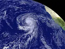
By the afternoon of September 8, an eye began to develop within a central dense overcast.[11] Later that day, Fred intensified into a Category 1 hurricane with winds estimated at 75 mph (120 km/h).[12] By the morning of September 9, satellite imagery depicted that Fred had undergone rapid intensification and attained Category 2 status.[13] This resulted from the formation of a 12 mi (19 km) wide eye[14] due to low wind shear and high sea surface temperatures.[13] This intensification continued for several more hours, ending with Fred attaining satellite-estimated its peak intensity as a solid Category 3 hurricane with winds of 120 mph (195 km/h)[15] and an estimated barometric pressure of 958 mbar (hPa; 28.29 inHg), making it the second strongest storm of the season.[16]
Hours after attaining its peak intensity, Fred began to weaken as clouds began to fill the eye. By this time, the hurricane was beginning to turn toward the northwest as a subtropical ridge to the north weakened.[17] Continued weakening took place as dry air started to erode convection along the southern edge of the system and the eye was no longer present on satellite imagery and wind shear also increased.[18] Convection gradually became elongated in response to the shear and outflow was mostly restricted to the northeast region of the hurricane.[19] By September 10, the mid-level circulation center was displaced from the low-level circulation center.[20] On September 11, the convective pattern of Fred had no organized shape to it and the NHC downgraded the hurricane to a tropical storm.[21] Unrelenting shear and dry air finally took their toll on September 12. By that time, no deep convection was associated with the main circulation of Fred, leaving the center fully exposed.[22] The storm degenerated into a remnant-low later that day, corresponding with the final advisory from the National Hurricane Center.[23]
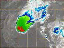
On September 13, despite being in an extremely hostile environment with very high wind shear, convection redeveloped near the center of Fred, and regeneration into a tropical cyclone was seen as a possibility.[24] Two days later, the NHC noted that environmental conditions could become marginally favorable for redevelopment of the system.[25] On September 16, the circulation of Fred became less defined and only intermittent convection persisted around the system.[26] By September 17, the remnant circulation became increasingly disorganized and the system dissipated later that day without regenerating into a tropical cyclone.[27][28] However, several hours later, a new area of low pressure formed in association with the remnants of Fred roughly 525 mi (845 km) south of Bermuda.[29] The remnant low finally dissipated on September 19, roughly 520 mi (835 km) southwest of Bermuda.[1]
Remnant moisture from Hurricane Fred contributed to the 2009 Southeastern United States floods, which caused 10 fatalities and produced damages estimated at $250 million.[30]
Historical perspective and impact
Over the years that the Atlantic hurricane basin has been thoroughly studied since 1851, there was only one other storm prior to Hurricane Fred to attain Category 3 intensity south of 30°N and east of 35°W.[15][31] This storm was Hurricane Frances in 1980. Frances attained major hurricane status farther south and east than Fred;[31] however, Fred was the strongest of the two,[15] peaking with estimated winds of 120 mph (195 km/h) and a minimum pressure of 958 mbar (hPa; 28.29 inHg).[1] Just over a year later, this intensity record was broken by Hurricane Julia, which attained winds of 140 mph (220 km/h) and a pressure of 948 mbar (hPa; 27.99 inHg) at 17.7°N and 32.2°W, becoming the easternmost-forming Category 4 hurricane on record.[32] In one of the NHC's discussions on Hurricane Fred, it was mentioned that due to the unusual location of a storm of its intensity, the hurricane would likely have gone unnoticed before the advent of satellite imagery in the 1960s.[15]
Several hours before being declared a tropical depression, the precursor to Fred produced moderate rainfall and gusty winds across the southern Cape Verde Islands.[3] In the city of Praia, Cape Verde, only a trace of rain, less than 0.1 in (2.5 mm) fell on September 7 and sustained winds reached 25 mph (35 km/h).[33] The increased winds and heavy rains led to the cancellation of two flights and the delay of several others.[34]
See also
| Wikimedia Commons has media related to Hurricane Fred (2009). |
- Timeline of the 2009 Atlantic hurricane season
- Hurricane Frances (1980)
- Hurricane Julia (2010)
- Hurricane Fred (2015) – became the easternmost Atlantic hurricane before moving through Cape Verde
References
- Michael J. Brennan (October 23, 2009). "Hurricane Fred Tropical Cyclone Report" (PDF). National Hurricane Center. Retrieved November 2, 2009.
- Richard Pasch (September 6, 2009). "Tropical Weather Outlook". National Hurricane Center. Retrieved September 9, 2009.
- Richard Pasch (September 7, 2009). "Tropical Weather Outlook". National Hurricane Center. Retrieved September 9, 2009.
- Daniel Brown (September 7, 2009). "Tropical Weather Outlook". National Hurricane Center. Retrieved September 9, 2009.
- Daniel Brown (September 7, 2009). "Tropical Depression Seven Public Advisory One". National Hurricane Center. Retrieved September 9, 2009.
- Daniel Brown (September 7, 2009). "Tropical Depression Seven Discussion One". National Hurricane Center. Retrieved September 9, 2009.
- Michael Brennan (September 7, 2009). "Tropical Storm Fred Public Advisory Two". National Hurricane Center. Retrieved September 12, 2009.
- Oficina Nacional de Meteorología, Centro de Información Huracanes (2004). "Reports of hurricanes, tropical storms, tropical disturbances and related flooding during 2003" (PDF). Archived from the original (PDF) on October 29, 2005. Retrieved September 12, 2009.
- Michael Brennan (September 7, 2009). "Tropical Storm Fred Discussion Two". National Hurricane Center. Retrieved September 12, 2009.
- Richard Pasch (September 8, 2009). "Tropical Storm Fred Discussion Three". National Hurricane Center. Retrieved September 12, 2009.
- Eric Blake (September 8, 2009). "Tropical Storm Fred Discussion Five". National Hurricane Center. Retrieved September 12, 2009.
- Robbie Berg (September 8, 2009). "Hurricane Fred Public Advisory Six". National Hurricane Center. Retrieved September 12, 2009.
- Richard Pasch (September 9, 2009). "Hurricane Fred Discussion Seven". National Hurricane Center. Retrieved September 12, 2009.
- Richard Pasch (September 9, 2009). "Hurricane Fred Forecast Advisory Seven". National Hurricane Center. Retrieved September 12, 2009.
- Eric Blake (September 9, 2009). "Hurricane Fred Discussion Eight". National Hurricane Center. Retrieved September 9, 2009.
- Eric Blake (September 9, 2009). "Hurricane Fred Public Advisory Eight". National Hurricane Center. Retrieved September 12, 2009.
- Eric Blake (September 9, 2009). "Hurricane Fred Discussion Nine". National Hurricane Center. Retrieved September 12, 2009.
- Robbie Berg (September 9, 2009). "Hurricane Fred Discussion Ten". National Hurricane Center. Retrieved September 12, 2009.
- Lixion A. Avila (September 10, 2009). "Hurricane Fred Discussion Thirteen". National Hurricane Center. Retrieved September 12, 2009.
- Robbie Berg (September 10, 2009). "Hurricane Fred Discussion Fourteen". National Hurricane Center. Retrieved September 12, 2009.
- Lixion A. Avila (September 11, 2009). "Tropical Storm Fred Discussion Seventeen". National Hurricane Center. Retrieved September 12, 2009.
- Eric Blake (September 12, 2009). "Tropical Storm Fred Discussion Nineteen". National Hurricane Center. Retrieved September 12, 2009.
- Todd Kimberlain (September 12, 2009). "Tropical Depression Fred Discussion Twenty-One (Final)". National Hurricane Center. Retrieved September 12, 2009.
- "Tropical Weather Outlook (update)". National Hurricane Center. September 13, 2009. Archived from the original on August 25, 2009. Retrieved September 13, 2009.
- Daniel Brown (September 15, 2009). "Tropical Weather Outlook". National Hurricane Center. Retrieved September 17, 2009.
- Eric Blake (September 16, 2009). "Tropical Weather Outlook". National Hurricane Center. Retrieved September 17, 2009.
- Lixion A. Avila (September 17, 2009). "Tropical Weather Outlook". National Hurricane Center. Retrieved September 17, 2009.
- Daniel Brown (September 17, 2009). "Tropical Weather Outlook". National Hurricane Center. Retrieved September 17, 2009.
- Jack Beven (September 17, 2009). "Tropical Weather Outlook". National Hurricane Center. Retrieved September 17, 2009.
- "RPT-U.S. flood damage in Georgia to top $250 mln". Reuters. September 23, 2009.
- Hurricane Specialists Unit (2009). "Easy to Read HURDAT 1851-2008". National Hurricane Center. Retrieved September 9, 2009.
- John L. Beven and Christopher W. Landsea (December 9, 2010). "Hurricane Julia Tropical Cyclone Report" (PDF). National Hurricane Center. Retrieved January 17, 2011.
- Local Resident of Praia, Cape Verde (September 7, 2009). "Weather History for Praia, Cape Verde on September 7". Weather Underground. Retrieved September 12, 2009.
- Staff Writer (September 8, 2009). "TACV e Halcyonair cancelam voos devido ao mau tempo". A Semana (in Portuguese). Archived from the original on March 3, 2016. Retrieved September 12, 2009.
