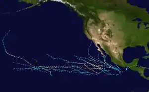
Hurricane Norman (1978)
Hurricane Norman was the most recent tropical system to make landfall in California. The 14th named storm, 11th hurricane, and 6th major hurricane of the 1978 Pacific hurricane season, Norman evolved from a tropical disturbance noted 400 mi (640 km; 350 nmi) southeast of Acapulco on the afternoon of August 29, 1978. The system moved westward and developed into a tropical depression on August 30. Modest strengthening ensued, and the cyclone became a tropical storm that evening and a hurricane on the evening of August 31 as it turned to the west-northwest. Late on the night of September 1, Norman became a major hurricane with an eye 40 miles (64 km; 35 nmi) wide, and a nearby ship reported seas of 41 ft (12 m). The center grazed the northeast side of Socorro Island on the afternoon of September 2. Moving over cooler waters west of Baja California, the cyclone slowly weakened. By early on September 4, moisture from the hurricane spread north into California initiating rains in the Golden State. A developing trough to its west caused the initial influx of moisture and Norman's turn to the north as a weakening tropical storm. Eventually turning north-northeast towards southern California, the cyclone did eventually turn north-northeast towards southern California, and the cyclone weakened to a tropical depression as it passed the 30th parallel. Hurricane Norman made landfall in California on September 5, as a minimal tropical depression.[1] The tropical cyclone became a remnant low shortly after California landfall, and the final advisory was issued at 00:00 GMT, on September 6. Over 7.01 in (178 mm) of rain occurred in the Sierra Nevada range.[2] Rare late-summer snowfall was also reported in the higher mountains, killing several hikers.
| Category 4 major hurricane (SSHWS/NWS) | |
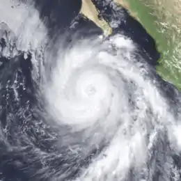 Hurricane Norman at peak intensity south of the Baja Peninsula on September 2 | |
| Formed | August 30, 1978 |
|---|---|
| Dissipated | September 6, 1978 |
| Highest winds | 1-minute sustained: 140 mph (220 km/h) |
| Fatalities | 4 indirect, 17 missing |
| Damage | $500 million (1978 USD) |
| Areas affected | California, Nevada, Arizona |
| Part of the 1978 Pacific hurricane season | |
Meteorological history

This system evolved from a tropical disturbance noted 400 miles (640 km; 350 nmi) southeast of Acapulco on the afternoon of August 29, 1978. The system moved westward and developed into a tropical depression on August 30. Modest strengthening ensued, and the cyclone became a tropical storm that evening and a hurricane on the evening of August 31 as it turned to the west-northwest.
Late on the night of 1 September 1978, Norman became a major hurricane with an eye 40 miles (64 km; 35 nmi) wide, and a nearby ship reported seas of 41 ft (12 m). The center grazed the northeast side of Socorro Island on the afternoon of 2 September. Moving over cooler waters west of Baja California, the cyclone slowly weakened.
By early on September 4, moisture from the hurricane spread north into California initiating rains in the Golden State. A developing trough to its west caused the initial influx of moisture and Norman's turn to the north as a weakening tropical storm. Eventually turning north-northeast towards southern California, the cyclone did eventually turn north-northeast towards southern California, and the cyclone weakened to a tropical depression as it passed the 30th parallel.[3] Hurricane Norman made landfall in California on September 5, as a minimal tropical depression. The tropical cyclone became a remnant low shortly after California landfall, and the final advisory was issued at 00:00 GMT, on September 6.[4][5]
The hurricane's strongest winds came at 120 mph (190 km/h; 100 kn). These winds occurred on September 3 approximately 900 kilometers off the coast of Jalisco, Mexico. Hurricane Norman caused an increase in precipitation throughout the Rocky Mountains.[6][7]
Preparations and impact
A flash flood watch was issued for the mountainous terrain and the desert region from Kern County to the California-Mexico border by the US National Weather Service.
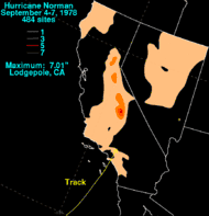
A large amount of rain was produced, with over 7.01 in (178 mm) of rain occurred in the Sierra Nevada range at Lodgepole in Sequoia National Park.[2] Rainfall was most intense on September 5 and September 6, with amounts exceeding 3 in (76 mm) in the mountains of southern California.[8] In addition, Norman produced waves up to 15 feet (4.6 m) high.[9]
The extratropical remains of Hurricane Norman also moved into Nevada produced very significant amounts of rainfall in the extreme central to northern portion of the state.[10] Power lines were knocked down, and caused a brief power failure from Santa Barbara to San Diego, reported by the Los Angeles Department of Water and Power, the Southern California Edison and the San Diego Gas and Electric.[9] The high winds tossed about ships in local harbors and damaging agricultural crops in Southern California, such as raisin crops, and damage to raisins were extensive throughout Kern, Tulare, and Stanislaus Counties. The rainfall also damaged grapes and other varieties of grapes. Over 126,500 people had to be rescued due to high waves. A 250-foot (76 m), US$1,150,000 cruiser was smashed and destroyed when a surf came ashore 150 feet (46 m) at Dana Point.[2]
Rare late summer snow was also reported in some areas of the Sierra (especially Mt. Whitney), and the blizzard killed at least four people, and at least seventeen others were missing. It dumped at least 5 inches (13 cm) of snow in many hiking areas. The storm also produced surging tides at the Los Angeles Harbor, and swept a 10,000-ton tanker from its moorings.[11] Many search and rescue teams in Inyo County went on a search, and many hikers had to be rescued. At least three hikers that were reported missing in the Italy Lake area had to be rescued.[12] The tropical cyclone had managed to cause US$500 million (1978 USD) in damages.[13]
See also
| Wikimedia Commons has media related to Hurricane Norman (1978). |
References
- Duginski, Paul (August 22, 2019). "Could a hurricane lash Los Angeles? 80 years ago, this deadly storm came close". Los Angeles Times. Retrieved August 28, 2019.
- "Hurricane Norman - August 30-September 6". Hydrometeorological Prediction Center. Retrieved 2013-06-02.
- "Hurricane NORMAN". National Oceanic and Atmospheric Administration. 1978.
- Emil B. Guther (1978). "Tropical cyclones of the 1978 Pacific hurricane season".
- Emil B. Guther (1979). "Tropical cyclones of the 1978 Pacific hurricane season". Monthly Weather Review. Eastern Pacific Hurricane Center. 107: 911–927. Bibcode:1979MWRv..107..911G. doi:10.1175/1520-0493(1979)107<0911:ENPTCO>2.0.CO;2. Retrieved 2013-06-02.
- "Unisys Weather". Retrieved 2016-02-01.
- Taubensee, Robert (December 1978). "WEATHER AND CIRCULATION OF SEPTEMBER 1978". Monthly Weather Review. doi:10.1175/1520-0493(1978)106<1750:WACOS>2.0.CO;2. Retrieved 2016-02-02.
- Jack Williams (May 17, 2005). "Hurricanes in the Western US". USA TODAY. Retrieved 2011-12-02.
- United Press International (1978-09-05). "Los Angeles Braced For Storm's Remnants". Ellensburg Daily Record. Retrieved 2011-12-02.
- Associated Press (1978-09-06). "Tropical Storm Weaker". The Victoria Advocate. Retrieved 2013-06-02.
- Associated Press (1978-09-07). "Summer Snow Brings Death To Four Hikers". The Day. Retrieved 2013-06-02.
- Associated Press (September 7, 1978). "California Snow Storm Kills Hikers". Williamson Daily News.
- Oard, Michael (March 1, 2015). The New Weather Book (Wonders of Creation). Master Books. p. 54. ISBN 0890518610.