Tulare County, California
Tulare County (/tʊˈlɛəri/ tuu-LAIR-ee) is a county in the U.S. state of California. As of the 2010 census, the population was 442,179.[4] Its county seat is Visalia.[6] The county is named for Tulare Lake, once the largest freshwater lake west of the Great Lakes. Drained for agricultural development, the site is now in Kings County, which was created in 1893 from the western portion of the formerly larger Tulare County.
Tulare County, California | |
|---|---|
| County of Tulare | |
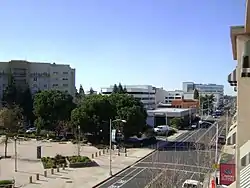   .JPG.webp) Images, from top down, left to right: Acequia Avenue in Visalia, Allensworth Hotel in Colonel Allensworth State Historic Park, Moro Rock in Sequoia National Park, Lake Kaweah | |
 Seal | |
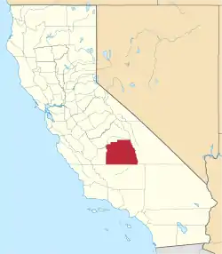 Tulare County's location in California | |
 Tulare County Location in California  Tulare County LOcation in the United States | |
| Coordinates: 36.23°N 118.80°W | |
| Country | |
| State | |
| Regions | San Joaquin Valley and Sierra Nevada |
| Metro area | Visalia-Porterville Metropolitan Area |
| Incorporated | 1852 |
| Named for | Tulare Lake, which is named for the tule rush that lined its shores |
| County seat | Visalia |
| Largest city | Visalia |
| Incorporated cities | 8 |
| Government | |
| • Administrative Officer | Jason Britt[1] |
| • Board of Supervisors[2] | Supervisors
|
| Area | |
| • Total | 4,839 sq mi (12,530 km2) |
| • Land | 4,824 sq mi (12,490 km2) |
| • Water | 14 sq mi (40 km2) |
| Highest elevation | 14,501 ft (4,420 m) |
| Population | |
| • Total | 442,179 |
| • Estimate (2019)[5] | 466,195 |
| • Density | 91/sq mi (35/km2) |
| Time zone | UTC−8 (Pacific) |
| • Summer (DST) | UTC−7 (PDT) |
| Area code | 559, 661 |
| FIPS code | 06-107 |
| GNIS feature ID | 277318 |
| Website | www |
Tulare County comprises the Visalia-Porterville, CA Metropolitan Statistical Area. The county is located south of Fresno, spanning from the San Joaquin Valley east to the Sierra Nevada.
Sequoia National Park is located in the county, as are part of Kings Canyon National Park, in its northeast corner (shared with Fresno County), and part of Mount Whitney, on its eastern border (shared with Inyo County). As of the 2010 census, the population was 442,179, up from 368,021 at the 2000 census.
History
.jpg.webp)
The land was occupied for thousands of years by the Yokuts. Beginning in the eighteenth century, Spain established missions to colonize California and convert the American Indians to Christianity. Comandante Pedro Fages, while hunting for deserters in the Central Valley in 1772, discovered a great lake surrounded by marshes and filled with rushes; he named it Los Tules (the tules). It is from this lake that the county derives its name. The root of the name Tulare is found in the Nahuatl word tullin, designating cattail or similar reeds.
In 1805, 1806 and again in 1816, the Spanish out of Mission San Luis Obispo explored Lake Tulare.[7] Bubal was a native village located on the Western side of Lake Tulare. In 1816, Fr. Luis Martinez of Mission San Luis Obispo arrived at Bubal with soldiers and armed Christian Northern Chumash pressuring the people to send their children for baptism at his mission on the coast. Conflict broke out, and Martinez's party burned Bubal to the ground, destroying the cache of food harvested for the winter.[8] Although Bubal's relationship with the Christian Salinans under Fr. Cabot at Mission San Miguel was better, between 1816 and 1834, Bubal was a center of native resistance. The marshes around Lake Tulare were impenetrable by Spanish horses, which gave the Yokuts a military advantage. At one point, the Spanish considered building a presidio with 100 soldiers at Bubal to control the resistance, but that never came to pass. The Spanish called the natives of the area Tulareños, and before 1816 and after 1834, they were incorporated into Mission San Miguel and Mission San Luis Obispo.[8]
After Mexico achieved independence, it continued to rule California. After the Mexican Cession and the Treaty of Guadalupe Hidalgo in 1848, the area became part of the United States. Tulare County was soon formed from parts of Mariposa County only 4 years later in 1852. There were two early attempts to split off a new Buena Vista County in 1855, and Coso County in 1864, but both failed. Parts of the county's territory were given to Fresno County in 1856, to Kern County and to Inyo County in 1866 and to Kings County in 1893.
The infectious disease Tularemia caused by the bacterium Francisella tularensis is named after Tulare County.
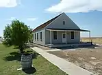
In 1908 Colonel Allen Allensworth and associates founded Allensworth as a black farming community. They intended to develop a place where African Americans could thrive free of white discrimination. It was the only community in California founded, financed and governed by African Americans. While its first years were highly successful, the community encountered environmental problems from dropping water tables which eventually caused it to fail. Today the historic area is preserved as the Colonel Allensworth State Historic Park, which is listed on the National Register of Historic Places.
Geography
According to the U.S. Census Bureau, the county has a total area of 4,839 square miles (12,530 km2), of which 4,824 square miles (12,490 km2) is land and 14 square miles (36 km2) (0.3%) is water.[9]
Adjacent counties

- Fresno County—north
- Inyo County—east
- Kern County—south
- Kings County—west
Lakes
- Arctic Lake
- Bullfrog Lakes
- Columbine Lake
- Crescent Lake
- Eagle Lake
- Franklin Lakes
- Lake Kaweah
- Lake Success
- Rockslide Lake
- Rocky Basin Lakes
- Weaver Lake
Rivers
- Angora River
- Alpine River
- Kaweah River
- Needlerock River
- Monarch River
- Negro River
- St. John's River
- Tule River
- Yokohl River
- Yucca River
Parks
- Colonel Allensworth State Historic Park
- Alpaugh Park
- Balch Park
- Bartlett Park
- Cutler Park
- Dry Creek Preserve
- Horse Creek Recreation Area
- Kaweah Oaks Preserve
- Kings River Nature Preserve
- Lackeys Cabin
- Lake Kaweah Recreation Area
- Mineral King Game Refuge
- Mooney Grove Park / Ancient Oak Forest Preserve
- Sequoia National Park
- Woodville Park
- West Main Street Park
National protected areas
Sequoia National Park
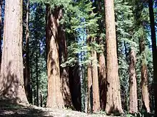
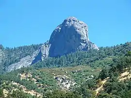
Sequoia National Park is a national park in the southern Sierra Nevada, east of Visalia. It was established in 1890 as the second U.S. national park, after Yellowstone. The park spans 404,051 acres (1,635.14 km2). Encompassing a vertical relief of nearly 13,000 feet (3,962 m), the park contains among its natural resources the highest point in the contiguous 48 United States, Mount Whitney, at 14,505 feet (4,421 m) above sea level. The park is south of and contiguous with Kings Canyon National Park; the two are administered by the National Park Service as one unit, called Sequoia and Kings Canyon National Parks.
Flora
Tulare County is rich in native plant species due in part to a diversity in habitats, including creeks, rivers, hills, and mountains. Native plants include incense cedar (Calocedrus decurrens), valley oak (Quercus lobata), California bay (Umbellularia californica), manzanita (Arctostaphylos manzanita), Salvia spathacea, mountain mahogany (Cercocarpus betuloides), milkweed (Asclepias speciosa), Epilobium cleistogamum, monkeyflower (Mimulus), Penstemon, California melic (Melica californica), and deer grass (Muhlenbergia rigens).[10]
Government and policing
Administration
Tulare County is a general law county under the California Constitution. That is, it does not have a county charter. The county is governed by a five-member Board of Supervisors. Supervisors are elected by districts for four-year terms. There are no term limits in effect. The Chairman and Vice-Chairman are elected annually by the Board of Supervisors from among its members.
Sheriff
The Tulare County Sheriff provides court protection, county jail operation, patrol and detective functions in the unincorporated areas of the county. Incorporated towns have municipal police departments or contract with the Sheriff for their police operations.
Transportation
Major highways
Public transportation
Tulare County Transit provides a countywide bus service linking the population centers. A connection to Delano in Kern County is also operated.
The cities of Tulare, Porterville, and Visalia have their own local bus services.
Greyhound and Orange Belt Stages provide long-distance, intercity bus service.
Airports
The Porterville Municipal Airport located 3 nautical miles from Downtown Porterville has very limited commercial passenger service with WestAir. The airport offers general aviation to the public, it is also home to Porterville Air Attack Base on the south part of the airport. The Visalia Municipal Airport is a city-owned airport for the city of Visalia, California. Mefford Field is a city-owned general aviation airport located in Tulare.
The nearest full operation commercial airports are Bakersfield's Meadows Field Airport to the South, and Fresno's Fresno Yosemite International Airport to the North.
Crime
The following table includes the number of incidents reported and the rate per 1,000 persons for each type of offense.
| Population and crime rates | ||
|---|---|---|
| Population[11] | 436,234 | |
| Violent crime[12] | 2,230 | 5.11 |
| Homicide[12] | 31 | 0.07 |
| Forcible rape[12] | 132 | 0.30 |
| Robbery[12] | 488 | 1.12 |
| Aggravated assault[12] | 1,579 | 3.62 |
| Property crime[12] | 9,123 | 20.91 |
| Burglary[12] | 4,139 | 9.49 |
| Larceny-theft[12][note 1] | 9,326 | 21.38 |
| Motor vehicle theft[12] | 2,216 | 5.08 |
| Arson[12] | 91 | 0.21 |
Cities by population and crime rates
| Cities by population and crime rates | ||||||||
|---|---|---|---|---|---|---|---|---|
| City | Population[13] | Violent crimes[13] | Violent crime rate per 1,000 persons |
Property crimes[13] | Property crime rate per 1,000 persons | |||
| Dinuba | 21,999 | 181 | 8.23 | 919 | 41.77 | |||
| Exeter | 10,596 | 28 | 2.64 | 306 | 28.88 | |||
| Farmersville | 10,860 | 34 | 3.13 | 227 | 20.90 | |||
| Lindsay | 12,068 | 49 | 4.06 | 321 | 26.60 | |||
| Porterville | 55,533 | 200 | 3.60 | 1,807 | 32.54 | |||
| Tulare | 60,848 | 376 | 6.18 | 2,400 | 39.44 | |||
| Visalia | 127,604 | 544 | 4.26 | 5,531 | 43.35 | |||
| Woodlake | 7,466 | 48 | 6.43 | 211 | 28.26 | |||
Demographics
2011
| Population, race, and income | |||||
|---|---|---|---|---|---|
| Total population[11] | 436,234 | ||||
| White[11] | 343,225 | 78.7% | |||
| Black or African American[11] | 7,130 | 1.6% | |||
| American Indian or Alaska Native[11] | 5,635 | 1.3% | |||
| Asian[11] | 15,151 | 3.5% | |||
| Native Hawaiian or other Pacific Islander[11] | 289 | 0.1% | |||
| Some other race[11] | 50,819 | 11.6% | |||
| Two or more races[11] | 13,985 | 3.2% | |||
| Hispanic or Latino (of any race)[14] | 260,798 | 59.8% | |||
| Per capita income[15] | $17,986 | ||||
| Median household income[16] | $43,550 | ||||
| Median family income[17] | $46,881 | ||||
Places by population, race, and income
| Places by population and race | ||||||||
|---|---|---|---|---|---|---|---|---|
| Place | Type[18] | Population[11] | White[11] | Other[11] [note 2] |
Asian[11] | Black or African American[11] |
Native American[11] [note 3] |
Hispanic or Latino (of any race)[14] |
| Allensworth | CDP | 281 | 90.7% | 0.4% | 1.8% | 7.1% | 0.0% | 84.7% |
| Alpaugh | CDP | 847 | 86.3% | 9.6% | 0.0% | 2.4% | 1.8% | 74.5% |
| California Hot Springs | CDP | 67 | 98.5% | 1.5% | 0.0% | 0.0% | 0.0% | 0.0% |
| Camp Nelson | CDP | 119 | 100.0% | 0.0% | 0.0% | 0.0% | 0.0% | 0.0% |
| Cedar Slope | CDP | 0 | 0.0% | 0.0% | 0.0% | 0.0% | 0.0% | 0.0% |
| Cutler | CDP | 4,312 | 80.6% | 17.6% | 1.9% | 0.0% | 0.0% | 97.4% |
| Delft Colony | CDP | 492 | 61.6% | 38.4% | 0.0% | 0.0% | 0.0% | 93.1% |
| Dinuba | City | 21,163 | 70.7% | 26.6% | 1.9% | 0.0% | 0.8% | 85.8% |
| Ducor | CDP | 454 | 66.1% | 33.9% | 0.0% | 0.0% | 0.0% | 65.4% |
| Earlimart | CDP | 7,225 | 84.2% | 13.6% | 2.0% | 0.0% | 0.1% | 96.4% |
| East Orosi | CDP | 231 | 59.7% | 40.3% | 0.0% | 0.0% | 0.0% | 100.0% |
| East Porterville | CDP | 6,585 | 78.1% | 18.3% | 2.3% | 0.1% | 1.2% | 75.4% |
| East Tulare Villa | CDP | 1,004 | 81.6% | 13.1% | 4.7% | 0.6% | 0.0% | 70.6% |
| El Rancho | CDP | 41 | 100.0% | 0.0% | 0.0% | 0.0% | 0.0% | 100.0% |
| Exeter | City | 10,255 | 86.4% | 11.0% | 0.0% | 1.6% | 1.0% | 45.8% |
| Farmersville | City | 10,445 | 83.2% | 15.3% | 0.4% | 0.0% | 1.1% | 81.7% |
| Goshen | CDP | 3,586 | 81.6% | 14.2% | 1.2% | 2.5% | 0.5% | 80.0% |
| Hartland | CDP | 0 | 0.0% | 0.0% | 0.0% | 0.0% | 0.0% | 0.0% |
| Idlewild | CDP | 29 | 82.8% | 0.0% | 0.0% | 0.0% | 17.2% | 0.0% |
| Ivanhoe | CDP | 4,614 | 86.0% | 13.2% | 0.9% | 0.0% | 0.0% | 81.3% |
| Kennedy Meadows | CDP | 18 | 100.0% | 0.0% | 0.0% | 0.0% | 0.0% | 0.0% |
| Lemon Cove | CDP | 202 | 93.1% | 2.0% | 0.0% | 5.0% | 0.0% | 27.7% |
| Lindcove | CDP | 350 | 85.1% | 12.0% | 0.0% | 0.0% | 2.9% | 54.0% |
| Lindsay | City | 11,664 | 79.4% | 17.2% | 2.6% | 0.7% | 0.1% | 86.5% |
| Linnell Camp | CDP | 735 | 96.6% | 3.4% | 0.0% | 0.0% | 0.0% | 100.0% |
| London | CDP | 1,927 | 76.6% | 18.9% | 2.6% | 0.0% | 1.8% | 90.4% |
| McClenney Tract | CDP | 6 | 100.0% | 0.0% | 0.0% | 0.0% | 0.0% | 0.0% |
| Matheny | CDP | 1,116 | 72.5% | 16.6% | 0.0% | 9.3% | 1.6% | 55.7% |
| Monson | CDP | 33 | 75.8% | 0.0% | 0.0% | 0.0% | 24.2% | 33.3% |
| Orosi | CDP | 9,347 | 59.0% | 28.5% | 11.2% | 0.5% | 0.7% | 84.8% |
| Panorama Heights | CDP | 43 | 74.4% | 25.6% | 0.0% | 0.0% | 0.0% | 0.0% |
| Patterson Tract | CDP | 1,817 | 66.5% | 17.5% | 5.2% | 0.0% | 10.8% | 63.2% |
| Pierpoint | CDP | 19 | 100.0% | 0.0% | 0.0% | 0.0% | 0.0% | 0.0% |
| Pine Flat | CDP | 114 | 64.9% | 35.1% | 0.0% | 0.0% | 0.0% | 0.0% |
| Pixley | CDP | 2,957 | 74.5% | 16.5% | 2.6% | 5.7% | 0.7% | 75.5% |
| Plainview | CDP | 1,101 | 58.0% | 40.7% | 0.0% | 0.0% | 1.3% | 91.6% |
| Ponderosa | CDP | 52 | 100.0% | 0.0% | 0.0% | 0.0% | 0.0% | 0.0% |
| Poplar-Cotton Center | CDP | 1,991 | 69.9% | 7.8% | 21.8% | 0.0% | 0.4% | 61.9% |
| Porterville | City | 53,531 | 72.8% | 18.9% | 5.1% | 1.0% | 2.2% | 61.0% |
| Posey | CDP | 6 | 100.0% | 0.0% | 0.0% | 0.0% | 0.0% | 0.0% |
| Poso Park | CDP | 0 | 0.0% | 0.0% | 0.0% | 0.0% | 0.0% | 0.0% |
| Richgrove | CDP | 2,592 | 56.2% | 41.6% | 2.3% | 0.0% | 0.0% | 97.3% |
| Rodriguez Camp | CDP | 205 | 51.2% | 21.5% | 0.0% | 0.0% | 27.3% | 100.0% |
| Sequoia Crest | CDP | 28 | 100.0% | 0.0% | 0.0% | 0.0% | 0.0% | 0.0% |
| Seville | CDP | 732 | 81.8% | 17.5% | 0.0% | 0.0% | 0.7% | 98.0% |
| Silver City | CDP | 0 | 0.0% | 0.0% | 0.0% | 0.0% | 0.0% | 0.0% |
| Springville | CDP | 1,071 | 75.2% | 24.0% | 0.0% | 0.0% | 0.8% | 27.8% |
| Strathmore | CDP | 3,758 | 78.1% | 21.9% | 0.0% | 0.0% | 0.0% | 85.5% |
| Sugarloaf Mountain Park | CDP | 0 | 0.0% | 0.0% | 0.0% | 0.0% | 0.0% | 0.0% |
| Sugarloaf Saw Mill | CDP | 0 | 0.0% | 0.0% | 0.0% | 0.0% | 0.0% | 0.0% |
| Sugarloaf Village | CDP | 15 | 100.0% | 0.0% | 0.0% | 0.0% | 0.0% | 0.0% |
| Sultana | CDP | 391 | 73.1% | 26.9% | 0.0% | 0.0% | 0.0% | 64.5% |
| Terra Bella | CDP | 3,299 | 59.3% | 39.9% | 0.7% | 0.0% | 0.2% | 90.7% |
| Teviston | CDP | 1,217 | 87.9% | 2.1% | 1.7% | 7.3% | 1.0% | 84.1% |
| Three Rivers | CDP | 2,155 | 95.1% | 2.9% | 1.1% | 0.4% | 0.5% | 6.3% |
| Tipton | CDP | 2,050 | 90.3% | 9.3% | 0.0% | 0.1% | 0.2% | 79.5% |
| Tonyville | CDP | 299 | 70.6% | 17.1% | 0.0% | 0.0% | 12.4% | 100.0% |
| Tooleville | CDP | 129 | 91.5% | 8.5% | 0.0% | 0.0% | 0.0% | 65.1% |
| Traver | CDP | 1,046 | 83.1% | 14.0% | 1.7% | 0.0% | 1.2% | 87.1% |
| Tulare | City | 58,150 | 78.7% | 12.9% | 2.5% | 4.7% | 1.2% | 56.6% |
| Visalia | City | 121,882 | 80.6% | 10.6% | 5.4% | 2.3% | 1.2% | 44.1% |
| Waukena | CDP | 148 | 95.3% | 4.7% | 0.0% | 0.0% | 0.0% | 66.9% |
| West Goshen | CDP | 597 | 92.8% | 5.9% | 0.0% | 1.3% | 0.0% | 78.6% |
| Wilsonia | CDP | 0 | 0.0% | 0.0% | 0.0% | 0.0% | 0.0% | 0.0% |
| Woodlake | City | 7,252 | 73.6% | 25.2% | 0.4% | 0.2% | 0.5% | 86.8% |
| Woodville | CDP | 1,992 | 86.2% | 13.0% | 0.0% | 0.0% | 0.8% | 88.5% |
| Yettem | CDP | 279 | 99.3% | 0.7% | 0.0% | 0.0% | 0.0% | 99.3% |
| Places by population and income | |||||
|---|---|---|---|---|---|
| Place | Type[18] | Population[19] | Per capita income[15] | Median household income[16] | Median family income[17] |
| Allensworth | CDP | 281 | $7,046 | $24,375 | $22,917 |
| Alpaugh | CDP | 847 | $7,603 | $22,875 | $22,344 |
| California Hot Springs | CDP | 67 | $16,221 | $33,750 | $36,250 |
| Camp Nelson | CDP | 119 | $25,273 | $9,939 | $85,568 |
| Cedar Slope | CDP | 0 | [20] | [20] | [20] |
| Cutler | CDP | 4,312 | $9,239 | $32,940 | $24,922 |
| Delft Colony | CDP | 492 | $22,098 | $52,986 | $52,986 |
| Dinuba | City | 21,163 | $13,606 | $40,463 | $38,358 |
| Ducor | CDP | 454 | $15,291 | $50,833 | $50,417 |
| Earlimart | CDP | 7,225 | $8,514 | $26,148 | $27,540 |
| East Orosi | CDP | 231 | $6,941 | $29,938 | $14,938 |
| East Porterville | CDP | 6,585 | $11,164 | $27,924 | $27,528 |
| East Tulare Villa | CDP | 1,004 | $13,639 | $42,734 | $42,888 |
| El Rancho | CDP | 41 | $4,598 | [20] | [20] |
| Exeter | City | 10,255 | $17,087 | $42,446 | $52,273 |
| Farmersville | City | 10,445 | $10,417 | $33,441 | $35,346 |
| Goshen | CDP | 3,586 | $9,295 | $33,750 | $32,905 |
| Hartland | CDP | 0 | [20] | [20] | [20] |
| Idlewild | CDP | 29 | $9,407 | $21,786 | [20] |
| Ivanhoe | CDP | 4,614 | $12,457 | $36,543 | $37,423 |
| Kennedy Meadows | CDP | 18 | [20] | [20] | [20] |
| Lemon Cove | CDP | 202 | $13,419 | $32,500 | $32,500 |
| Lindcove | CDP | 350 | $14,589 | $33,929 | $33,929 |
| Lindsay | City | 11,664 | $10,770 | $29,750 | $30,648 |
| Linnell Camp | CDP | 735 | $6,384 | $27,743 | $28,576 |
| London | CDP | 1,927 | $8,931 | $33,382 | $28,869 |
| McClenney Tract | CDP | 6 | $6,800 | $2,499 | [20] |
| Matheny | CDP | 1,116 | $13,350 | $29,605 | $28,421 |
| Monson | CDP | 33 | $18,018 | $35,417 | $47,500 |
| Orosi | CDP | 9,347 | $9,230 | $35,512 | $33,734 |
| Panorama Heights | CDP | 43 | $20,298 | $19,500 | [20] |
| Patterson Tract | CDP | 1,817 | $15,091 | $37,240 | $36,853 |
| Pierpoint | CDP | 19 | [20] | [20] | [20] |
| Pine Flat | CDP | 114 | $13,583 | $15,724 | $15,750 |
| Pixley | CDP | 2,957 | $11,976 | $27,532 | $28,750 |
| Plainview | CDP | 1,101 | $6,715 | $19,922 | $18,750 |
| Ponderosa | CDP | 52 | $45,581 | $102,833 | $102,833 |
| Poplar-Cotton Center | CDP | 1,991 | $11,487 | $29,756 | $29,238 |
| Porterville | City | 53,531 | $16,705 | $39,933 | $45,208 |
| Posey | CDP | 6 | [20] | [20] | [20] |
| Poso Park | CDP | 0 | [20] | [20] | [20] |
| Richgrove | CDP | 2,592 | $8,166 | $29,776 | $28,788 |
| Rodriguez Camp | CDP | 205 | $7,116 | $28,125 | $28,125 |
| Sequoia Crest | CDP | 28 | [20] | [20] | [20] |
| Seville | CDP | 732 | $11,195 | $50,833 | $50,417 |
| Silver City | CDP | 0 | [20] | [20] | [20] |
| Springville | CDP | 1,071 | $22,872 | $39,726 | $43,494 |
| Strathmore | CDP | 3,758 | $8,265 | $31,650 | $26,612 |
| Sugarloaf Mountain Park | CDP | 0 | [20] | [20] | [20] |
| Sugarloaf Saw Mill | CDP | 0 | [20] | [20] | [20] |
| Sugarloaf Village | CDP | 15 | $24,453 | $43,750 | $52,500 |
| Sultana | CDP | 391 | $13,913 | $30,956 | $31,875 |
| Terra Bella | CDP | 3,299 | $9,280 | $27,419 | $27,500 |
| Teviston | CDP | 1,217 | $9,244 | $25,532 | $25,691 |
| Three Rivers | CDP | 2,155 | $34,977 | $62,218 | $74,375 |
| Tipton | CDP | 2,050 | $12,476 | $40,972 | $48,684 |
| Tonyville | CDP | 299 | $3,469 | $13,750 | $13,750 |
| Tooleville | CDP | 129 | $14,376 | $25,882 | $24,479 |
| Traver | CDP | 1,046 | $12,639 | $39,375 | $36,731 |
| Tulare | City | 58,150 | $17,922 | $46,274 | $50,049 |
| Visalia | City | 121,882 | $23,571 | $54,019 | $61,520 |
| Waukena | CDP | 148 | $14,540 | $32,625 | $34,500 |
| West Goshen | CDP | 597 | $8,629 | $24,083 | $24,667 |
| Wilsonia | CDP | 0 | [20] | [20] | [20] |
| Woodlake | City | 7,252 | $11,539 | $32,013 | $33,295 |
| Woodville | CDP | 1,992 | $11,200 | $31,792 | $29,758 |
| Yettem | CDP | 279 | $7,303 | $24,917 | $24,917 |
2010
The 2010 United States Census reported that Tulare County had a population of 442,179. The racial makeup of Tulare County was 265,618 (60.1%) White, 7,196 (1.6%) African American, 6,993 (1.6%) Native American, 15,176 (3.4%) Asian, 509 (0.1%) Pacific Islander, 128,263 (29.0%) from other races, and 18,424 (4.2%) from two or more races. There were 268,065 people (60.6%) of Hispanic or Latino origin, of any race.[21]
| Population reported at 2010 United States Census | |||||||||
|---|---|---|---|---|---|---|---|---|---|
Population | American | American | Islander | races | more races | or Latino (of any race) | |||
| Tulare County | 442,179 | 265,618 | 7,196 | 6,993 | 15,176 | 509 | 128,263 | 18,424 | 268,065 |
cities | Population | American | American | Islander | races | more races | or Latino (of any race) | ||
| Dinuba | 21,453 | 11,166 | 141 | 193 | 454 | 17 | 8,630 | 852 | 18,114 |
| Exeter | 10,334 | 7,150 | 67 | 171 | 138 | 8 | 2,416 | 384 | 4,703 |
| Farmersville | 10,588 | 5,295 | 60 | 213 | 72 | 5 | 4,494 | 449 | 8,876 |
| Lindsay | 11,768 | 6,480 | 85 | 128 | 267 | 4 | 4,367 | 437 | 10,056 |
| Porterville | 54,165 | 31,847 | 673 | 1,007 | 2,521 | 64 | 15,482 | 2,571 | 33,549 |
| Tulare | 59,278 | 36,347 | 2,328 | 694 | 1,276 | 80 | 15,713 | 2,840 | 34,062 |
| Visalia | 124,442 | 80,203 | 2,627 | 1,730 | 6,768 | 164 | 27,249 | 5,701 | 57,262 |
| Woodlake | 7,279 | 3,691 | 37 | 108 | 52 | 9 | 3,072 | 310 | 6,381 |
places | Population | American | American | Islander | races | more races | or Latino (of any race) | ||
| Allensworth | 471 | 158 | 22 | 0 | 8 | 0 | 279 | 4 | 436 |
| Alpaugh | 1,026 | 381 | 4 | 11 | 4 | 0 | 597 | 29 | 867 |
| California Hot Springs | 37 | 34 | 0 | 0 | 1 | 0 | 0 | 2 | 3 |
| Camp Nelson | 97 | 94 | 0 | 0 | 0 | 0 | 2 | 1 | 6 |
| Cedar Slope | 0 | 0 | 0 | 0 | 0 | 0 | 0 | 0 | 0 |
| Cutler | 5,000 | 2,421 | 50 | 53 | 64 | 1 | 2,241 | 170 | 4,829 |
| Delft Colony | 454 | 213 | 13 | 0 | 0 | 0 | 224 | 4 | 428 |
| Ducor | 612 | 251 | 0 | 15 | 20 | 0 | 302 | 24 | 502 |
| Earlimart | 8,537 | 3,193 | 67 | 45 | 536 | 0 | 4,303 | 393 | 7,805 |
| East Orosi | 495 | 209 | 0 | 5 | 2 | 1 | 261 | 17 | 466 |
| East Porterville | 6,767 | 3,660 | 65 | 153 | 102 | 58 | 2,431 | 298 | 4,930 |
| East Tulare Villa | 778 | 491 | 9 | 6 | 10 | 0 | 226 | 36 | 428 |
| El Rancho | 124 | 71 | 1 | 1 | 0 | 0 | 49 | 2 | 117 |
| Goshen | 3,006 | 1,186 | 76 | 90 | 11 | 1 | 1,496 | 146 | 2,482 |
| Hartland | 30 | 27 | 3 | 0 | 0 | 0 | 0 | 0 | 0 |
| Idlewild | 43 | 43 | 0 | 0 | 0 | 0 | 0 | 0 | 0 |
| Ivanhoe | 4,495 | 2,002 | 19 | 80 | 29 | 1 | 2,221 | 143 | 3,752 |
| Kennedy Meadows | 28 | 25 | 0 | 1 | 0 | 0 | 2 | 0 | 3 |
| Lemon Cove | 308 | 261 | 0 | 5 | 3 | 2 | 12 | 25 | 76 |
| Lindcove | 406 | 284 | 2 | 15 | 0 | 0 | 96 | 9 | 197 |
| Linnell Camp | 849 | 397 | 3 | 18 | 8 | 0 | 393 | 30 | 832 |
| London | 1,869 | 761 | 6 | 46 | 0 | 0 | 976 | 80 | 1,737 |
| Matheny | 1,212 | 651 | 44 | 24 | 4 | 0 | 436 | 53 | 890 |
| McClenney Tract | 10 | 9 | 0 | 0 | 0 | 0 | 0 | 1 | 0 |
| Monson | 188 | 121 | 1 | 5 | 4 | 0 | 57 | 0 | 147 |
| Orosi | 8,770 | 3,861 | 65 | 57 | 803 | 1 | 3,638 | 345 | 7,606 |
| Panorama Heights | 41 | 35 | 1 | 1 | 0 | 0 | 4 | 0 | 4 |
| Patterson Tract | 1,752 | 999 | 0 | 33 | 73 | 0 | 577 | 70 | 1,133 |
| Pierpoint | 52 | 51 | 0 | 0 | 0 | 0 | 1 | 0 | 1 |
| Pine Flat | 166 | 158 | 0 | 3 | 3 | 0 | 0 | 2 | 11 |
| Pixley | 3,310 | 1,473 | 90 | 28 | 16 | 0 | 1,587 | 116 | 2,675 |
| Plainview | 945 | 358 | 8 | 20 | 2 | 0 | 517 | 40 | 865 |
| Ponderosa | 16 | 13 | 0 | 0 | 0 | 0 | 1 | 2 | 4 |
| Poplar-Cotton Center | 2,470 | 1,729 | 1 | 15 | 356 | 0 | 327 | 42 | 1,809 |
| Posey | 10 | 6 | 0 | 3 | 0 | 0 | 0 | 1 | 3 |
| Poso Park | 9 | 9 | 0 | 0 | 0 | 0 | 0 | 0 | 0 |
| Richgrove | 2,882 | 1,068 | 20 | 38 | 140 | 7 | 1,521 | 88 | 2,705 |
| Rodriguez Camp | 156 | 51 | 0 | 0 | 0 | 0 | 98 | 7 | 151 |
| Sequoia Crest | 10 | 10 | 0 | 0 | 0 | 0 | 0 | 0 | 0 |
| Seville | 480 | 200 | 0 | 5 | 0 | 0 | 259 | 16 | 458 |
| Silver City | 0 | 0 | 0 | 0 | 0 | 0 | 0 | 0 | 0 |
| Springville | 934 | 836 | 5 | 20 | 7 | 0 | 25 | 41 | 109 |
| Strathmore | 2,819 | 1,490 | 12 | 41 | 7 | 1 | 1,162 | 106 | 2,238 |
| Sugarloaf Mountain Park | 0 | 0 | 0 | 0 | 0 | 0 | 0 | 0 | 0 |
| Sugarloaf Saw Mill | 18 | 14 | 0 | 0 | 0 | 0 | 1 | 3 | 4 |
| Sugarloaf Village | 10 | 9 | 0 | 0 | 0 | 0 | 0 | 1 | 2 |
| Sultana | 775 | 315 | 0 | 3 | 6 | 0 | 424 | 27 | 695 |
| Terra Bella | 3,310 | 1,426 | 5 | 20 | 75 | 2 | 1,733 | 49 | 2,894 |
| Teviston | 1,214 | 449 | 50 | 9 | 10 | 0 | 640 | 56 | 1,039 |
| Three Rivers | 2,182 | 1,976 | 7 | 27 | 31 | 1 | 75 | 65 | 212 |
| Tipton | 2,543 | 1,535 | 3 | 15 | 9 | 0 | 924 | 57 | 2,147 |
| Tonyville | 316 | 178 | 0 | 0 | 12 | 0 | 115 | 11 | 286 |
| Tooleville | 339 | 145 | 5 | 19 | 8 | 2 | 148 | 12 | 279 |
| Traver | 713 | 302 | 1 | 22 | 6 | 2 | 357 | 23 | 551 |
| Waukena | 108 | 86 | 0 | 3 | 0 | 0 | 19 | 0 | 45 |
| West Goshen | 511 | 276 | 2 | 10 | 7 | 0 | 195 | 21 | 358 |
| Wilsonia | 5 | 5 | 0 | 0 | 0 | 0 | 0 | 0 | 0 |
| Woodville | 1,740 | 1,345 | 1 | 31 | 6 | 0 | 324 | 33 | 1,545 |
| Yettem | 211 | 48 | 5 | 0 | 0 | 0 | 148 | 10 | 199 |
unincorporated areas | Population | American | American | Islander | races | more races | or Latino (of any race) | ||
| All others not CDPs (combined) | 67,213 | 46,040 | 512 | 1,753 | 1,245 | 78 | 15,416 | 2,169 | 34,101 |
2000
| Historical population | |||
|---|---|---|---|
| Census | Pop. | %± | |
| 1860 | 4,638 | — | |
| 1870 | 4,533 | −2.3% | |
| 1880 | 11,281 | 148.9% | |
| 1890 | 24,574 | 117.8% | |
| 1900 | 18,375 | −25.2% | |
| 1910 | 35,440 | 92.9% | |
| 1920 | 59,031 | 66.6% | |
| 1930 | 77,442 | 31.2% | |
| 1940 | 107,152 | 38.4% | |
| 1950 | 149,264 | 39.3% | |
| 1960 | 168,403 | 12.8% | |
| 1970 | 188,322 | 11.8% | |
| 1980 | 245,738 | 30.5% | |
| 1990 | 311,921 | 26.9% | |
| 2000 | 368,021 | 18.0% | |
| 2010 | 442,179 | 20.2% | |
| 2019 (est.) | 466,195 | [5] | 5.4% |
| U.S. Decennial Census[22] 1790-1960[23] 1900-1990[24] 1990-2000[25] 2010-2015[4] | |||
As of the census[26] of 2000, there were 368,021 people, 110,385 households, and 87,093 families residing in the county. The population density was 76 people per square mile (29/km2). There were 119,639 housing units at an average density of 25 per square mile (10/km2). The racial makeup of the county was 58.1% White, 1.6% Black or African American, 1.6% Native American, 3.3% Asian, 0.1% Pacific Islander, 30.8% from other races, and 4.6% from two or more races. 50.8% of the population were Hispanic or Latino of any race. 6.2% were of American, 5.7% German and 5.0% English ancestry according to Census 2000. 56.3% spoke English, 38.9% Spanish and 1.1% Portuguese as their first language.
There were 110,385 households, out of which 44.9% had children under the age of 18 living with them, 58.1% were married couples living together, 14.5% had a female householder with no husband present, and 21.1% were non-families. 17.1% of all households were made up of individuals, and 7.7% had someone living alone who was 65 years of age or older. The average household size was 3.28 and the average family size was 3.67.
In the county, the population was spread out, with 33.8% under the age of 18, 10.6% from 18 to 24, 27.6% from 25 to 44, 18.2% from 45 to 64, and 9.8% who were 65 years of age or older. The median age was 29 years. For every 100 females there were 100.0 males. For every 100 females age 18 and over, there were 97.7 males.
The median income for a household in the county was $33,983, and the median income for a family was $36,297. Males had a median income of $30,892 versus $24,589 for females. The per capita income for the county was $14,006. About 18.8% of families and 23.9% of the population were below the poverty line, including 32.6% of those under age 18 and 10.5% of those age 65 or over.
Crime statistics
(reported by the sheriff's office or county police)[27]
- Murders: 30
- Rapes: 40
- Robberies: 87
- Assaults: 411
- Burglaries: 1328
- Thefts: 2117
- Auto thefts: 11
Metropolitan Statistical Area
The United States Office of Management and Budget has designated Tulare County as the Visalia-Porterville, CA Metropolitan Statistical Area.[28] The United States Census Bureau ranked the Visalia-Porterville, CA Metropolitan Statistical Area as the 111th most populous metropolitan statistical area of the United States as of July 1, 2012.[29]
The Office of Management and Budget has further designated the Visalia-Porterville, CA Metropolitan Statistical Area as a component of the more extensive Visalia-Porterville-Hanford, CA Combined Statistical Area,[28] the 80th most populous combined statistical area and the 92nd most populous primary statistical area of the United States as of July 1, 2012.[29][30]
Politics
Voter registration statistics
| Population and registered voters | ||
|---|---|---|
| Total population[11] | 436,234 | |
| Registered voters[31][note 4] | 144,863 | 33.2% |
| Democratic[31] | 49,183 | 34.0% |
| Republican[31] | 63,336 | 43.7% |
| Democratic–Republican spread[31] | -14,153 | -9.7% |
| Independent[31] | 4,826 | 3.3% |
| Green[31] | 474 | 0.3% |
| Libertarian[31] | 737 | 0.5% |
| Peace and Freedom[31] | 454 | 0.3% |
| Americans Elect[31] | 13 | 0.0% |
| Other[31] | 265 | 0.2% |
| No party preference[31] | 25,575 | 17.7% |
Cities by population and voter registration
| Cities by population and voter registration | |||||||
|---|---|---|---|---|---|---|---|
| City | Population[11] | Registered voters[31] [note 4] |
Democratic[31] | Republican[31] | D–R spread[31] | Other[31] | No party preference[31] |
| Dinuba | 21,163 | 30.0% | 44.4% | 35.4% | +9.0% | 5.5% | 16.9% |
| Exeter | 10,255 | 40.2% | 26.9% | 50.6% | -23.7% | 9.9% | 16.8% |
| Farmersville | 10,445 | 22.4% | 46.9% | 24.3% | +22.6% | 8.9% | 23.9% |
| Lindsay | 11,664 | 20.8% | 47.4% | 23.8% | +23.6% | 7.7% | 24.0% |
| Porterville | 53,531 | 29.3% | 36.3% | 39.3% | -3.0% | 8.7% | 19.3% |
| Tulare | 58,150 | 34.9% | 35.6% | 42.1% | -6.5% | 7.8% | 17.8% |
| Visalia | 121,882 | 42.4% | 31.1% | 46.4% | -15.3% | 8.5% | 17.4% |
| Woodlake | 7,252 | 22.4% | 52.7% | 21.0% | +31.7% | 7.6% | 21.6% |
Overview
Tulare is a strongly Republican county in Presidential and congressional elections. The last Democratic candidate for president to win a majority in the county was Lyndon Johnson in 1964. In the 2016 presidential election, Republican candidate and overall winner, Donald Trump, won Tulare by a 9.39% margin of victory, the closest margin of victory for a Republican in the county since Richard Nixon's 8.37% margin in 1960. The Republican advantage narrowed further in the 2020 presidential election when Donald Trump won the county by a 7.82% margin despite losing nationally to Joe Biden.
| Year | GOP | DEM | Others |
|---|---|---|---|
| 2020 | 52.8% 77,579 | 45.0% 66,105 | 2.1% 3,201 |
| 2016 | 51.0% 58,299 | 41.7% 47,585 | 7.2% 8,218 |
| 2012 | 56.2% 56,956 | 41.2% 41,752 | 2.5% 2,571 |
| 2008 | 56.6% 59,765 | 41.3% 43,634 | 2.0% 2,126 |
| 2004 | 66.1% 65,399 | 32.8% 32,494 | 0.9% 967 |
| 2000 | 60.2% 54,070 | 36.7% 33,006 | 3.0% 2,742 |
| 1996 | 53.9% 46,272 | 38.0% 32,669 | 8.0% 6,905 |
| 1992 | 45.7% 40,482 | 35.2% 31,188 | 19.0% 16,883 |
| 1988 | 59.6% 46,891 | 39.0% 30,711 | 1.3% 1,067 |
| 1984 | 63.8% 51,066 | 35.1% 28,065 | 1.0% 812 |
| 1980 | 58.3% 41,317 | 35.5% 25,155 | 6.1% 4,374 |
| 1976 | 54.5% 31,864 | 43.7% 25,551 | 1.7% 1,027 |
| 1972 | 59.9% 36,048 | 36.2% 21,775 | 3.8% 2,327 |
| 1968 | 52.1% 29,314 | 39.4% 22,180 | 8.3% 4,695 |
| 1964 | 39.8% 22,527 | 60.0% 33,974 | 0.0% 51 |
| 1960 | 53.9% 29,456 | 45.6% 24,887 | 0.4% 239 |
| 1956 | 52.5% 26,051 | 47.1% 23,407 | 0.3% 160 |
| 1952 | 57.0% 30,108 | 42.1% 22,208 | 0.8% 437 |
| 1948 | 46.9% 18,414 | 50.2% 19,681 | 2.8% 1,097 |
| 1944 | 49.3% 16,005 | 49.9% 16,221 | 0.7% 238 |
| 1940 | 42.8% 15,414 | 55.9% 20,129 | 1.1% 428 |
| 1936 | 30.7% 8,624 | 67.6% 18,956 | 1.5% 435 |
| 1932 | 32.2% 8,066 | 62.5% 15,631 | 5.2% 1,302 |
| 1928 | 63.7% 12,057 | 35.0% 6,635 | 1.1% 218 |
| 1924 | 50.7% 9,484 | 18.3% 3,425 | 30.8% 5,765 |
| 1920 | 61.2% 9,136 | 32.4% 4,837 | 6.3% 941 |
| 1916 | 43.9% 6,845 | 46.8% 7,299 | 9.1% 1,428 |
| 1912 | 0.7% 73 | 42.3% 4,293 | 56.9% 5,781 |
| 1908 | 47.9% 2,742 | 40.7% 2,329 | 11.3% 647 |
| 1904 | 48.6% 2,221 | 35.9% 1,643 | 15.4% 705 |
| 1900 | 41.4% 1,755 | 53.0% 2,246 | 5.5% 237 |
| 1896 | 33.8% 1,410 | 64.0% 2,673 | 2.1% 89 |
| 1892 | 31.9% 1,984 | 42.0% 2,613 | 25.9% 1,611 |
| 1888 | 43.8% 2,275 | 50.7% 2,637 | 5.3% 280 |
| 1884 | 40.1% 1,268 | 53.5% 1,691 | 6.3% 199 |
| 1880 | 38.7% 917 | 55.1% 1,306 | 6.1% 146 |
In the United States House of Representatives, Tulare County is split between 3 congressional districts:[33]
- California's 21st congressional district, represented by Republican David Valadao
- California's 22nd congressional district, represented by Republican Devin Nunes and
- California's 23rd congressional district, represented by Republican Kevin McCarthy.[34]
In the California State Senate, it is split between 3 legislative districts:[35]
- the 8th Senate District, represented by Republican Andreas Borgeas,
- the 14th Senate District, represented by Democrat Melissa Hurtado, and
- the 16th Senate District, represented by Republican Shannon Grove.
In the California State Assembly, the county is split between the 23rd Assembly District, represented by Republican Jim Patterson, and the 26th Assembly District, represented by Republican Devon Mathis.[36]
Economy
The dairy industry, with sales of milk products, brings in the most revenue for the county, typically more than US$ 1 billion a year annually. Oranges, grapes, and cattle-related commodities also earn hundreds of millions of dollars annually.
In 2001, Tulare became the most productive county in the U.S. in terms of agricultural revenues, at US$3.5 billion annually. It surpassed Fresno County's US$3.2 billion, which had held the top spot for over two decades. Due to the importance of agriculture in the county as well as its location in the state, since 1968 the city of Tulare has been the site of the annual World Ag Expo,[37] the world's largest agricultural exposition.
Minor league sports teams, such as the baseball Visalia Rawhide of the class-A level California League (an affiliate to the Arizona Diamondbacks), two teams of the Minor League Football Association in Tulare and Visalia, and four teams of the Central California Basketball League based in Porterville, attract many residents and add to the amenities in the county.
Top employers
According to the county's 2010 Comprehensive Annual Financial Report,[38] the top employers in the county are:
| # | Employer | # of Employees |
|---|---|---|
| 1 | County of Tulare | 4,320 |
| 2 | Porterville Developmental Center | 3,000 |
| 3 | Kaweah Delta Medical Center | 2,000 |
| 4 | Ruiz Foods | 1,800 |
| 5 | Wal-Mart | 1,692 |
| 6 | College of the Sequoias | 1,160 |
| 7 | Cigna | 900 |
| 8 | Jostens | 720 |
| 9 | Land O'Lakes | 600 |
| 10 | Monrovia Nursery | 600 |
Utlities and infrastructure
Electricity service in Tulare County is served by Southern California Edison. TV and internet is served by Charter Spectrum.
Communities
Cities
- Dinuba
- Exeter
- Farmersville
- Lindsay
- Porterville
- Tulare
- Visalia (county seat)
- Woodlake
Census designated places
- Allensworth
- Alpaugh
- California Hot Springs
- Camp Nelson
- Cedar Slope
- Cutler
- Delft Colony
- Ducor
- Earlimart
- East Orosi
- East Porterville
- East Tulare Villa
- El Rancho
- Goshen
- Hartland
- Idlewild
- Ivanhoe
- Kennedy Meadows
- Lemon Cove
- Lindcove
- Linnell Camp
- London
- Matheny
- McClenney Tract
- Monson
- Orosi
- Panorama Heights
- Patterson Tract
- Pierpoint
- Pine Flat
- Pixley
- Plainview
- Ponderosa
- Poplar-Cotton Center
- Posey
- Poso Park
- Richgrove
- Rodriguez Camp
- Sequoia Crest
- Seville
- Silver City
- Springville
- Strathmore
- Sugarloaf Mountain Park
- Sugarloaf Saw Mill
- Sugarloaf Village
- Sultana
- Terra Bella
- Teviston
- Three Rivers
- Tipton
- Tonyville
- Tooleville
- Traver
- Waukena
- West Goshen
- Wilsonia
- Woodville
- Yettem
Other unincorporated communities
Indian reservation
Population ranking
The population ranking of the following table is based on the 2010 census of Tulare County.[39]
† county seat
| Rank | City/Town/etc. | Municipal type | Population (2010 Census) |
|---|---|---|---|
| 1 | † Visalia | City | 124,442 |
| 2 | Tulare | City | 59,278 |
| 3 | Porterville | City | 60,070 |
| 4 | Dinuba | City | 21,453 |
| 5 | Lindsay | City | 11,768 |
| 6 | Farmersville | City | 10,588 |
| 7 | Exeter | City | 10,334 |
| 8 | Orosi | CDP | 8,778 |
| 9 | Earlimart | CDP | 8,357 |
| 10 | East Porterville | CDP | 7,331 |
| 11 | Woodlake | City | 7,279 |
| 12 | Cutler | CDP | 5,000 |
| 13 | Ivanhoe | CDP | 4,495 |
| t-14 | Pixley | CDP | 3,310 |
| t-14 | Terra Bella | CDP | 3,310 |
| 15 | Goshen | CDP | 3,006 |
| 16 | Richgrove | CDP | 2,882 |
| 17 | Strathmore | CDP | 2,819 |
| 18 | Tipton | CDP | 2,543 |
| 19 | Poplar-Cotton Center | CDP | 2,470 |
| 20 | Three Rivers | CDP | 2,182 |
| 21 | London | CDP | 1,869 |
| 22 | Patterson Tract | CDP | 1,752 |
| 23 | Woodville | CDP | 1,740 |
| 24 | Teviston | CDP | 1,214 |
| 25 | Matheny | CDP | 1,212 |
| 26 | Tule River Reservation[40] | AIAN | 1,049 |
| 27 | Alpaugh | CDP | 1,026 |
| 28 | Plainview | CDP | 945 |
| 29 | Springville | CDP | 934 |
| 30 | Linnell Camp | CDP | 849 |
| 31 | East Tulare Villa | CDP | 778 |
| 32 | Sultana | CDP | 775 |
| 33 | Traver | CDP | 713 |
| 34 | Ducor | CDP | 612 |
| 35 | West Goshen | CDP | 511 |
| 36 | East Orosi | CDP | 495 |
| 37 | Seville | CDP | 480 |
| 38 | Allensworth | CDP | 471 |
| 39 | Delft Colony | CDP | 454 |
| 40 | Lindcove | CDP | 406 |
| 41 | Tooleville | CDP | 339 |
| 42 | Tonyville | CDP | 316 |
| 43 | Lemon Cove | CDP | 308 |
| 44 | Yettem | CDP | 211 |
| 45 | Monson | CDP | 188 |
| 46 | Pine Flat | CDP | 166 |
| 47 | Rodriguez Camp | CDP | 156 |
| 48 | El Rancho | CDP | 124 |
| 49 | Waukena | CDP | 108 |
| 50 | Camp Nelson | CDP | 97 |
| 51 | Pierpoint | CDP | 52 |
| 52 | Idlewild | CDP | 43 |
| 53 | Panorama Heights | CDP | 41 |
| 54 | California Hot Springs | CDP | 37 |
| 55 | Hartland | CDP | 30 |
| 56 | Kennedy Meadows | CDP | 28 |
| 57 | Sugarloaf Saw Mill | CDP | 18 |
| 58 | Ponderosa | CDP | 16 |
| t-59 | McClenney Tract | CDP | 10 |
| t-59 | Posey | CDP | 10 |
| t-59 | Sequoia Crest | CDP | 10 |
| t-59 | Sugarloaf Village | CDP | 10 |
| 60 | Poso Park | CDP | 9 |
| 61 | Wilsonia | CDP | 5 |
| t-62 | Cedar Slope | CDP | 0 |
| t-62 | Silver City | CDP | 0 |
| t-62 | Sugarloaf Mountain Park | CDP | 0 |
See also
Notes
- Only larceny-theft cases involving property over $400 in value are reported as property crimes.
- Other = Some other race + Two or more races
- Native American = Native Hawaiian or other Pacific Islander + American Indian or Alaska Native
- Percentage of registered voters with respect to total population. Percentages of party members with respect to registered voters follow.
References
- "County Administrative Officer - CAO". County of Tulare. Archived from the original on February 9, 2015. Retrieved February 8, 2015.
- "Home - Board of Supervisors". County of Tulare. Retrieved March 24, 2017.
- "Mount Whitney". Peakbagger.com. Retrieved February 9, 2015.
- "State & County QuickFacts". United States Census Bureau. Archived from the original on July 21, 2011. Retrieved April 6, 2016.
- "American FactFinder". Archived from the original on February 14, 2020. Retrieved April 19, 2019.
- "Find a County". National Association of Counties. Retrieved June 7, 2011.
- Cook, S. F. (1958). "Colonial Expeditions to the Interior of California Central Valley, 1800–1820" (PDF). Anthropological Records. 16 (6): 243, 245, 271. ISSN 0068-6336. Archived from the original (PDF) on June 14, 2020. Retrieved May 10, 2020. Alt URL
- Milliken, Randall; Johnson, John (2005). An ethnogeography of Salinan and Northern Chumash communities, 1769–1810. Davis, California: Far Western Anthropological Research Group. p. 22.
- "US Gazetteer files: 2010, 2000, and 1990". United States Census Bureau. February 12, 2011. Retrieved April 23, 2011.
- "Drought Tolerant Native Plants" (PDF). Archived from the original (PDF) on October 9, 2011. Retrieved 2009-11-22.
- U.S. Census Bureau. American Community Survey, 2011 American Community Survey 5-Year Estimates, Table B02001. U.S. Census website. Retrieved 2013-10-26.
- Office of the Attorney General, Department of Justice, State of California. Table 11: Crimes – 2009 Archived December 2, 2013, at the Wayback Machine. Retrieved 2013-11-14.
- United States Department of Justice, Federal Bureau of Investigation. Crime in the United States, 2012, Table 8 (California). Retrieved 2013-11-14.
- U.S. Census Bureau. American Community Survey, 2011 American Community Survey 5-Year Estimates, Table B03003. U.S. Census website. Retrieved 2013-10-26.
- U.S. Census Bureau. American Community Survey, 2011 American Community Survey 5-Year Estimates, Table B19301. U.S. Census website. Retrieved 2013-10-21.
- U.S. Census Bureau. American Community Survey, 2011 American Community Survey 5-Year Estimates, Table B19013. U.S. Census website. Retrieved 2013-10-21.
- U.S. Census Bureau. American Community Survey, 2011 American Community Survey 5-Year Estimates, Table B19113. U.S. Census website. Retrieved 2013-10-21.
- U.S. Census Bureau. American Community Survey, 2011 American Community Survey 5-Year Estimates. U.S. Census website. Retrieved 2013-10-21.
- U.S. Census Bureau. American Community Survey, 2011 American Community Survey 5-Year Estimates, Table B01003. U.S. Census website. Retrieved 2013-10-21.
- Data unavailable
- "2010 Census P.L. 94-171 Summary File Data". United States Census Bureau.
- "U.S. Decennial Census". United States Census Bureau. Retrieved May 31, 2014.
- "Historical Census Browser". University of Virginia Library. Retrieved May 31, 2014.
- "Population of Counties by Decennial Census: 1900 to 1990". United States Census Bureau. Retrieved May 31, 2014.
- "Census 2000 PHC-T-4. Ranking Tables for Counties: 1990 and 2000" (PDF). United States Census Bureau. Retrieved May 31, 2014.
- "U.S. Census website". United States Census Bureau. Retrieved May 14, 2011.
- "city-data-Tulare_County-CA". analyzed data from numerous sources. Retrieved April 7, 2009.
- "OMB Bulletin No. 13-01: Revised Delineations of Metropolitan Statistical Areas, Micropolitan Statistical Areas, and Combined Statistical Areas, and Guidance on Uses of the Delineations of These Areas" (PDF). United States Office of Management and Budget. February 28, 2013. Retrieved March 20, 2013.
- "Table 1. Annual Estimates of the Population of Metropolitan and Micropolitan Statistical Areas: April 1, 2010 to July 1, 2012". 2012 Population Estimates. United States Census Bureau, Population Division. March 2013. Archived from the original (CSV) on April 1, 2013. Retrieved March 20, 2013.
- "Table 2. Annual Estimates of the Population of Combined Statistical Areas: April 1, 2010 to July 1, 2012". 2012 Population Estimates. United States Census Bureau, Population Division. March 2013. Archived from the original (CSV) on May 17, 2013. Retrieved March 20, 2013.
- California Secretary of State. February 10, 2013 - Report of Registration Archived July 27, 2013, at the Wayback Machine. Retrieved 2013-10-31.
- Leip, David. "Dave Leip's Atlas of U.S. Presidential Elections". uselectionatlas.org. Retrieved September 6, 2018.
- "Counties by County and by District". California Citizens Redistricting Commission. Archived from the original on September 30, 2013. Retrieved September 24, 2014.
- "California's 23rd Congressional District - Representatives & District Map". Civic Impulse, LLC. Retrieved September 25, 2014.
- "Communities of Interest — County". California Citizens Redistricting Commission. Archived from the original on October 23, 2015. Retrieved September 28, 2014.
- "Communities of Interest — County". California Citizens Redistricting Commission. Archived from the original on October 23, 2015. Retrieved September 28, 2014.
- "International Agri-Center / Tulare, CA". www.worldagexpo.com.
- "County of Tulare CAFR". Archived from the original on July 18, 2011.
- Bureau, US Census. "Decennial Census by Decades". The United States Census Bureau.
Further reading
- Jennifer Medina, "With Dry Taps and Toilets, California Drought Turns Desperate," New York Times, Oct. 2, 2014.
External links
| Wikimedia Commons has media related to Tulare County, California. |
- Official website

- Tulare County Agricultural Commissioner/Sealer official website (with Annual Crop and Livestock Reports)
Places adjacent to Tulare County, California | ||||||||||
|---|---|---|---|---|---|---|---|---|---|---|
| ||||||||||
Municipalities and communities of Tulare County, California, United States | ||
|---|---|---|
| Cities | Tulare County map | |
| CDPs |
| |
| Unincorporated communities | ||
| Ghost towns |
| |
| Indian reservation | ||
| Other | ||
| ||
| Authority control |
|---|