IRS-1A
IRS-1A, the first of the series of indigenous state-of-art remote sensing satellites, was successfully launched into a polar sun-synchronous orbit on 17 March 1988 from the Soviet Cosmodrome at Baikonur. IRS-1A carries three cameras, LISS-1, LISS-2A and LISS-2B with resolutions of 72.5 metres (238 ft) and 36.25 metres (118.9 ft) respectively with a swath width of about 140 kilometres (87 mi) during each pass over the country. Undertaken by the Indian Space Research Organisation (ISRO). It was a part-operational, part-experimental mission to develop Indian expertise in satellite imagery.
| Mission type | Earth observation Remote sensing |
|---|---|
| Operator | ISRO |
| COSPAR ID | 1988-021A |
| SATCAT no. | 18960 |
| Mission duration | 3 years (planned) 8 years and 4 months |
| Spacecraft properties | |
| Bus | IRS-1A |
| Manufacturer | ISRO |
| Launch mass | 975 kg |
| Power | 600 watts |
| Start of mission | |
| Launch date | 17 March 1988, 06:43:00 UTC |
| Rocket | Vostok-2M s/n L15000-79 |
| Launch site | Baikonur, Site 31/6 |
| Contractor | OKB-1 |
| End of mission | |
| Last contact | July 1996 |
| Orbital parameters | |
| Reference system | Geocentric [1] |
| Regime | Sun-synchronous |
| Perigee altitude | 863 km |
| Apogee altitude | 917 km |
| Inclination | 99.01° |
| Period | 102.7 minutes |
| Epoch | 17 March 1988 |
History
IRS-1A was the first remote sensing mission to provide imagery for various land-based applications, such as agriculture, forestry, geology, and hydrology.[2] The mission's long-term objective was to develop indigenous remote sensing capability.[3]
Spacecraft
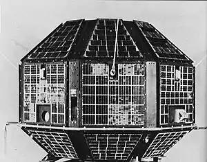
The spacecraft platform, measuring 1.56 x 1.66 x 1.10 metres, had the payload module attached on the top and a deployable solar array stowed on either side. Attitude control was provided by four-momentum wheels, two magnetic torques, and a thruster system. Together, they gave an estimated accuracy of better than ± 0.10° in all three axes.[2]
Payloads
IRS-1A carried three "Linear Imaging Self Scanner" cameras, LISS-1, LISS-2A and LISS-2B, with a spatial resolution of 72.5 metres (238 ft) and 36.25 metres (118.9 ft) respectively.[4] The three-axis-stabilised sun-synchronous satellite carried LISS cameras which performed "push-broom" scanning in visible and near-infrared bands to acquire images of the Earth. Local equatorial crossing time was fixed at around 10:30 of the morning.[2]
Mission
IRS-1A was operated in a Sun-synchronous orbit. On 17 March 1988, it had a perigee of 863 kilometres (536 mi), an apogee of 907 kilometres (564 mi), an inclination of 99.01°, and an orbital period of 102.7 minutes.[1]
IRS-1A successfully completed its mission in July 1996 after operating for 8 years and 4 months.
See also
References
- "IRS-1A: Trajectory 1988-021A". nssdc.gsfc.nasa.gov. NASA. 17 April 2020. Retrieved 2 May 2020.

- "IRS-1A: Display 1988-021A". nssdc.gsfc.nasa.gov. NASA. 17 April 2020. Retrieved 2 May 2020.
- "Indian Remote Sensing Satellite-1A". CEOS International Directory Network (IDN). Retrieved 8 April 2013.
- "IRS (Indian Remote Sensing Satellites) - Overview and early LEO Program of ISRO". eoPortal.org. Retrieved 8 April 2013.
External links
| Satellites |
|  | ||||||||||
|---|---|---|---|---|---|---|---|---|---|---|---|---|
| Space probes |
| |||||||||||
| Human spaceflight | ||||||||||||
| ||||||||||||