IRS-1C
IRS-1C was the fourth remote sensing Indian satellite built, and designed by Indian Space Research Organization (ISRO). IRS-1C is first second-generation operational Remote Sensing Satellite. The satellite carries payloads with enhanced capabilities like better spatial resolution additional spectral bands, improved repetitivity and augment the remote sensing capability of the existing IRS-1A and IRS-1B.
| Mission type | Earth observation Remote sensing |
|---|---|
| Operator | ISRO |
| COSPAR ID | 1995-072A |
| SATCAT no. | 23751 |
| Website | https://www.isro.gov.in/Spacecraft/irs-1c |
| Mission duration | 11 years and 8 months |
| Spacecraft properties | |
| Bus | IRS-1B |
| Manufacturer | ISRO |
| Launch mass | 1250 kg |
| Dimensions | 1.93 x 1.7 x 1.65 metres |
| Power | 809 watts |
| Start of mission | |
| Launch date | 28 December 1995 06:45:18 UTC |
| Rocket | Molniya-M / Blok 2BL s/n V15000-040 |
| Launch site | Baikonur, Site 31/6 |
| Contractor | Central Specialized Design Bureau (TsSKB) |
| End of mission | |
| Last contact | 21 September 2007 |
| Orbital parameters | |
| Reference system | Geocentric [1] |
| Regime | Sun-synchronous |
| Perigee altitude | 816 km |
| Apogee altitude | 818 km |
| Inclination | 98.69° |
| Period | 101.2 minutes |
| Epoch | 28 December 1995 |
Objective
The primary objective of IRS-1C was to provide systematic and repetitive acquisition of data of the Earth's surface under nearly constant illumination conditions.[2]
Spacecraft
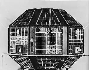
IRS 1-C was the fourth of the Indian natural resource imaging satellites and was launched by a Molniya-M rocket from the Baykonur Cosmodrome. The 1,250 kilograms (2,760 lb) spacecraft carried three instruments. Images from regions other than India will be downlinked and distributed through a commercial entity in the United States.
IRS-1C used S-band for broadcasting and X-band for uplinking of data. The satellite was equipped with onboard tape recorder with storage capacity of 62 Gbits.[3]
Payloads
IRS-1C was equipped with three sensors:
- Panchromatic (PAN) camera of 6 metres (20 ft) resolution
- Linear Imaging Self Scanner (LISS-3) of 23.6 metres (77 ft) resolution
- Wide Field Sensor (WiFS) of 189 metres (620 ft) resolution [4]
Mission
The images was marketed through a private company in the United States.[4] The data transmitted from the satellite was gathered from National Remote Sensing Centre, Hyderabad and EOSAT, a partnership of Hughes Aircraft and RCA.[5]
IRS-1C completed its services on 21 September 2007 after serving for 11 years and 8 months.[3]
See also
References
- "IRS-1C: Trajectory 1995-072A". nssdc.gsfc.nasa.gov. NASA. 17 April 2020. Retrieved 4 May 2020.
 This article incorporates text from this source, which is in the public domain.
 - "IRS-1C/1D" (PDF). National University of Argentina. p. 3. Retrieved 8 March 2013.
- "IRS-1C". Indian Space Research Organisation. Retrieved 4 May 2020.
- "IRS-1C: Display 1995-072A". nssdc.gsfc.nasa.gov. NASA. 17 April 2020. Retrieved 4 May 2020. This article incorporates text from this source, which is in the public domain.
- "IRS (Indian Remote Sensing Programme)". Federation of American Scientists. Retrieved 8 March 2013.
External links
| Satellites |
|  | ||||||||||
|---|---|---|---|---|---|---|---|---|---|---|---|---|
| Space probes |
| |||||||||||
| Human spaceflight | ||||||||||||
| ||||||||||||
