iSimangaliso Wetland Park
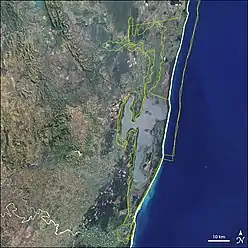
iSimangaliso Wetland Park (previously known as the Greater St. Lucia Wetland Park) is situated on the east coast of KwaZulu-Natal, South Africa, about 235 kilometres north of Durban by road. It is South Africa's third-largest protected area, spanning 280 km of coastline, from the Mozambican border in the north to Mapelane south of the Lake St. Lucia estuary, and made up of around 3,280 km2 of natural ecosystems, managed by the iSimangaliso Authority. The park includes:
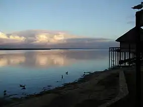
- Lake St. Lucia
- St. Lucia Game Reserve
- False Bay Park
- Kosi Bay
- Lake Eteza Nature Reserve
- Lake Sibhayi
- St. Lucia Marine Reserve
- St. Lucia Marine Sanctuary
- Sodwana Bay National Park
- Mapelane Nature Reserve
- Maputaland Marine Protected Area
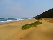
- Cape Vidal
- Ozabeni
- Mfabeni
- Tewate Wilderness Area
- Mkuze Game Reserve
| iSimangaliso Wetland Park | |
|---|---|
 Greater St. Lucia Wetlands | |
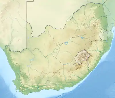 Location in South Africa | |
| Location | KwaZulu-Natal, South Africa |
| Nearest city | Durban, South Africa |
| Coordinates | 27°39′S 32°34′E |
| Area | 3,280 km2 (1,270 sq mi) |
| Established | 1895 |
| Governing body | iSimangaliso Authority |
| Criteria | Natural: (vii), (ix), (x) |
| Reference | 914 |
| Inscription | 1999 (23rd session) |
| Area | 239,566 ha (924.97 sq mi) |
| Website | http://www.isimangaliso.com/ |
| Official name | St. Lucia System |
| Designated | 2 October 1986 |
| Reference no. | 345[1] |
The park was previously known as the Greater St. Lucia Wetland Park, but was renamed effective 1 November 2007. The word isimangaliso means "a miracle" or "something wondrous" in Zulu. The name came as a result of Shaka's subject having been sent to the land of the Tsonga. When he came back he described the beauty that he saw as a miracle.
Transfrontier parks
The park is part of a transfrontier marine park, the Ponta do Ouro-Kosi Bay Transfrontier Conservation Area, straddling South Africa, Mozambique, and Eswatini.[2] The marine conservation area is included in the Greater Lubombo Transfrontier Conservation Area.[3][4][5][6]
History
Until 1895, the bay had been a home of the Tsonga people and their Tsonga fish kraal. This is the original and the natural home of the Tsonga people and they have lived here for more than 1000 years.[7] Records from early Portuguese sailors rightfully point out this area to be occupied by the Tsonga people and further down south. The area was also known as Tembeland or Thongaland but the name fell into disuse around the early 1900s. The area was ruled by a Tsonga branch of the Vahlanganu (Tembe). The Swiss missionary, Reverend Henri-Alexandre Junod (known as HA Junod), conducted a scientific and ethnographic study of the Tsonga people during the early 1890s and produced a detailed map, showing the occupation of the bay by the Tsonga Tembe people.[8] The Swiss Missionary, Rev Junod, illustrated in his detailed map that the area was known as Tembeland and that the Tembe capital city was located in the St Lucia bay. Rev Junod's map showed that by 1906, the Tsonga people occupied the land from St Lucia up until Valdezia in the Spelenkon district of the Transvaal province, known today as Limpopo Province. St Lucia bay and Maputo bay are one land and they belong to the Tsonga people, Tsonga villages were built from St Lucia bay until Maputo and they were not separated by any natural division. Around St Lucia, the ruling chief was the Tembe Royal Family, while around Maputo, the ruling class was the Maputo royal family, who are all of the Vahlanganu branch of the Tsonga people. In and around Maputo and St Lucia bay (Tembeland), the language spoken is Ronga, which according to the Swiss Missionary, Rev HA Junod, is not an independent language but a dialect of Xitsonga. According to Rev Junod, Ronga language is so similar to Xitsonga that it cannot be regarded an independent language but is a dialect of a major language known today as Xitsonga.
St. Lucia was first named in 1554 Rio dos Medos do Ouro (alternatively Rio dos Médãos do Ouro — River of the Gold Dunes)[9][10] by the survivors of the Portuguese ship Saint Benedict. At this stage, only the Tugela River mouth was known as St. Lucia. Later, in 1575, the Tugela River was named Tugela. On 13 December 1575, the day of the feast of Saint Lucy, Manuel Peresterello renamed the mouth area to Santa Lucia.
- In 1822, St. Lucia was proclaimed by the British as a township.
- In 1895, St. Lucia Game Reserve, 30 km north of the town was proclaimed.
- In 1971, St. Lucia Lake and the turtle beaches and coral reefs of Maputaland have been listed by the Convention on Wetlands of International Importance (Ramsar Convention).
- In December 1999, the park was declared a UNESCO World Heritage Site at an unveiling ceremony, where Nelson Mandela was the guest of honour.
Biodiversity
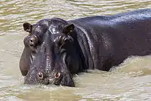
The park was proclaimed a world heritage site because of the rich biodiversity, unique ecosystems and natural beauty occurring in a relatively small area. The reason for the huge diversity in fauna and flora is the great variety of different ecosystems on the park, ranging from coral reefs and sandy beaches to subtropical dune forests, savannas, and wetlands. Animals occurring on the park include elephant, leopard, black and southern white rhino, Cape buffalo, and in the ocean, whales, dolphins, and marine turtles including the leatherback and loggerhead turtle.
The park is also home to 1,200 crocodiles and 800 hippopotami.
In December 2013, after 44 years of absence, African lions were reintroduced to iSimangaliso.[11]
There are large outcroppings of underwater reefs which are home to brightly coloured fish and corals. Some of the most spectacular coral diversity in the world is located in Sodwana Bay. The reefs are inhabited by colour-changing octopuses and squid ready to ambush unsuspecting prey. Occasionally gigantic whale sharks can be seen gliding through the water, mouth agape to scoop up tiny plankton.
Twenty-four species of bivalve molluscs are recorded in St. Lucia Lake, which constitutes a considerable portion of the park.[12]
Notes
- "St. Lucia System". Ramsar Sites Information Service. Retrieved 25 April 2018.
- Cole, Barbara (21 Oct 2009). "Transfrontier marine park a first". Independent on line. Retrieved 2020-04-06.
- "Lubombo". Peace Parks Foundation. Retrieved 2020-04-07.
- South African Department of Environmental Affairs. "Agreement on Lubombo Transfrontier Conservation Areas". Retrieved 7 April 2020.
- "Conservation Grant Flows to Africa's 'Miracle,' iSimangaliso Wetland Park". www.ens-newswire.com. 5 April 2010. Retrieved 2020-04-07.
- "Transfrontier Conservation Areas - Swaziland National Trust Commission". www.sntc.org.sz. Retrieved 2020-04-07.
- Mathebula, Mandla (2002), 800 Years of Tsonga History: 1200-2000, Burgersfort: Sasavona Publishers and Booksellers Pty Ltd.
- Junod, H.A. (1927). The Life of a South African Tribe, vol. I: Social Life. London: Macmillan.
- Gomes de Brito, Bernanrdo (1735). HISTORIA TRAGICO-MARITIMA Em que se escrevem chronologicamente os Naufragios que tiveraõ as Naos de Portugal, depois que se poz em exercicio a Navegação da India, Volume 1 (PDF) (in Portuguese). Lisbon: Officina da Congregação do Oratorio. p. 109. Archived from the original (PDF) on 11 November 2014. Retrieved 11 November 2014.
- Xavier Botelho, Sebastião (1835). Memoria estatistica sobre os dominios portuguezes na Africa Oriental, Volume 1 (in Portuguese). Lisbon: Typ. de José Baptista Morando. p. 77. Retrieved 11 November 2014.
- Nel, H. A., Perissinotto, R. & Taylor, R. H. 2012. Diversity of bivalve molluscs in the St. Lucia Estuary, with an annotated and illustrated checklist. African Invertebrates 53 (2): 503-525."Archived copy". Archived from the original on 2012-12-24. Retrieved 2012-11-14.CS1 maint: archived copy as title (link)
References
- "St. Lucia Estuary, South Africa". NASA Earth Observatory. Archived from the original on 2006-10-01. Retrieved 2006-05-19.
External links
| Wikimedia Commons has media related to ISimangaliso Wetland Park. |
For official site names, see each article or the List of World Heritage Sites in South Africa. | ||
| ||