Idaho State Highway 50
State Highway 50 (SH-50) is a 8.092-mile-long (13.023 km) state highway in the U.S. State of Idaho. SH-50 starts at U.S. Route 30 (US-30) before connecting to Interstate 84 (I-84) and ending at SH-25. It provides eastern access to the city of Twin Falls from I-84.
| ||||
|---|---|---|---|---|
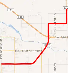
SH-50 highlighted in red | ||||
| Route information | ||||
| Maintained by ITD | ||||
| Length | 8.092 mi[1] (13.023 km) | |||
| Major junctions | ||||
| West end | ||||
| East end | ||||
| Location | ||||
| Counties | Twin Falls, Jerome | |||
| Highway system | ||||
| ||||

Route description
State Highway 50 starts at an intersection with US 30 near the town of Kimberly in Twin Falls County; the latter continues west into the city of Twin Falls. The highway continues east as a road named North 3800 East before turning to the northeast and crossing the Snake River on the Hansen Bridge into Jerome County. SH-50 continues as the road South 1150 East to a diamond interchange with I-84, where there is a truck stop on the southwest side of the interchange along a frontage road, as well as some commercial establishments on the southwest and northeast sides of the interchange.[2][1][3]
After crossing the freeway at an overpass, SH-50 continues due north before briefly turning east onto the road East 900 South. The road curves to the north again as it makes a sharp turn onto the road South 1300 East. SH-50 ends at an intersection with SH-25, where SH-25 makes a sharp turn from south to east; a connector route continues straight onto SH-25 heading north, while the main route curves to the east, continuing onto SH-25 heading due east. SH-50 passes through farmland for its entire length.[2][1][3] Despite its status as a connector route, SH-50 is not part of the National Highway System (NHS),[4] a network of roadways important to the country's economy, defense, and mobility.[5]
Junction list
| County | Location | mi[1] | km | Destinations | Notes |
|---|---|---|---|---|---|
| Twin Falls | | 0.000 | 0.000 | ||
| Jerome | | 4.647– 4.792 | 7.479– 7.712 | ||
| | 7.971 | 12.828 | |||
| | 8.092 | 13.023 | |||
| 1.000 mi = 1.609 km; 1.000 km = 0.621 mi | |||||
Connector route
| |
|---|---|
| Location | Near Eden |
| Length | 0.140 mi[1] (0.225 km) |
State Highway 50 Connector is a short route connecting SH-50 and SH-25. The entirety of the route is also known as South 1300 East. It connects SH-50 northbound with SH-25 southbound, and vice versa. [1]
References
- Staff (18 December 2006). "State Highway 50". Idaho Transportation Department. Archived from the original on 13 December 2012. Retrieved 13 July 2012.
- Google (13 July 2012). "State Highway 50" (Map). Google Maps. Google. Retrieved 13 July 2012.
- Official State Highway Map (Map) (2009 ed.). Cartography by Rand Mc Nally. Idaho Transportation Department. 2009. § L4. OCLC 659875959.
- National Highway System: Pocatello, ID (PDF) (Map). Cartography by FHWA. Federal Highway Administration. Retrieved July 13, 2012.
- Adderly, Kevin (August 26, 2010). "The National Highway System". Planning, Environment, and Realty. Federal Highway Administration. Retrieved January 1, 2011.
