Idanha-a-Nova
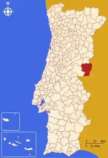
Idanha-a-Nova (Portuguese pronunciation: [iˈðɐɲa ˈnɔvɐ] (![]() listen)) is a municipality in the district of Castelo Branco in east-central Portugal. The population in 2011 was 9,716,[1] in an area of 1416.34 km², making it one of the largest municipalities in Portugal.[2] The municipal holiday is the Monday 15 days after Easter.
listen)) is a municipality in the district of Castelo Branco in east-central Portugal. The population in 2011 was 9,716,[1] in an area of 1416.34 km², making it one of the largest municipalities in Portugal.[2] The municipal holiday is the Monday 15 days after Easter.
Idanha-a-Nova | |
|---|---|
 Flag  Coat of arms | |
 | |
| Coordinates: 39°55′N 7°14′W | |
| Country | |
| Region | Centro |
| Intermunic. comm. | Beira Baixa |
| District | Castelo Branco |
| Parishes | 13 |
| Government | |
| • President | Armindo Moreira Palma Jacinto (PS) |
| Area | |
| • Total | 1,416.34 km2 (546.85 sq mi) |
| Population (2011) | |
| • Total | 9,716 |
| • Density | 6.9/km2 (18/sq mi) |
| Time zone | UTC±00:00 (WET) |
| • Summer (DST) | UTC+01:00 (WEST) |
| Local holiday | Monday 15 days after Easter |
| Website | http://www.cm-idanhanova.pt |
Idanha-a-Nova has hosted the massive biannual Boom Festival since 2002, during which the population of the community temporarily increases more than fivefold. The present mayor is Armindo Moreira Palma Jacinto, representing the Socialist Party.
Parishes
Administratively, the municipality is divided into 13 civil parishes (freguesias):[3]
- Aldeia de Santa Margarida
- Idanha-a-Nova e Alcafozes
- Ladoeiro
- Medelim
- Monfortinho e Salvaterra do Extremo
- Monsanto e Idanha-a-Velha
- Oledo
- Penha Garcia
- Proença-a-Velha
- Rosmaninhal
- São Miguel de Acha
- Toulões
- Zebreira e Segura
Climate
Idanha-a-Nova has a Mediterranean climate (Köppen: Csa) with cool to mild, rainy winters and hot, dry summers. The town is located at roughly 380 m (1,250 ft) altitude. Places at lower elevations (e.g. Ladoeiro, shown below) can get even hotter in the summer, with average daily temperatures rounding 33–34 °C (91–93 °F) in July and August.
| Climate data for Ladoeiro, Idanha-a-Nova, 1982-2000 normals and extremes, altitude: 180 m (590 ft) | |||||||||||||
|---|---|---|---|---|---|---|---|---|---|---|---|---|---|
| Month | Jan | Feb | Mar | Apr | May | Jun | Jul | Aug | Sep | Oct | Nov | Dec | Year |
| Record high °C (°F) | 26.0 (78.8) |
24.0 (75.2) |
29.8 (85.6) |
31.6 (88.9) |
35.5 (95.9) |
42.1 (107.8) |
42.0 (107.6) |
42.3 (108.1) |
40.8 (105.4) |
33.0 (91.4) |
25.6 (78.1) |
21.5 (70.7) |
42.3 (108.1) |
| Average high °C (°F) | 13.8 (56.8) |
15.7 (60.3) |
19.7 (67.5) |
20.4 (68.7) |
24.2 (75.6) |
29.7 (85.5) |
33.7 (92.7) |
33.2 (91.8) |
29.4 (84.9) |
23.3 (73.9) |
17.7 (63.9) |
14.9 (58.8) |
23.0 (73.4) |
| Daily mean °C (°F) | 7.6 (45.7) |
9.3 (48.7) |
11.9 (53.4) |
13.3 (55.9) |
16.8 (62.2) |
21.4 (70.5) |
24.6 (76.3) |
24.0 (75.2) |
21.0 (69.8) |
16.2 (61.2) |
11.9 (53.4) |
9.1 (48.4) |
15.6 (60.1) |
| Average low °C (°F) | 1.5 (34.7) |
2.8 (37.0) |
4.1 (39.4) |
6.2 (43.2) |
9.3 (48.7) |
13.1 (55.6) |
15.3 (59.5) |
14.5 (58.1) |
12.5 (54.5) |
9.2 (48.6) |
6.0 (42.8) |
3.5 (38.3) |
8.2 (46.7) |
| Record low °C (°F) | −8.0 (17.6) |
−6.5 (20.3) |
−6.0 (21.2) |
−4.8 (23.4) |
−1.5 (29.3) |
4.0 (39.2) |
6.8 (44.2) |
7.5 (45.5) |
4.0 (39.2) |
0.0 (32.0) |
−5.0 (23.0) |
−7.5 (18.5) |
−8.0 (17.6) |
| Average rainfall mm (inches) | 75.5 (2.97) |
52.1 (2.05) |
29.6 (1.17) |
53.1 (2.09) |
63.3 (2.49) |
21.8 (0.86) |
6.6 (0.26) |
5.0 (0.20) |
37.1 (1.46) |
78.4 (3.09) |
110.5 (4.35) |
110.8 (4.36) |
643.8 (25.35) |
| Average precipitation days (≥ 0.1 mm) | 10.2 | 7.6 | 6.1 | 9.1 | 8.9 | 3.4 | 1.6 | 1.6 | 5.5 | 9.3 | 10.3 | 11.0 | 84.6 |
| Source: Instituto de Meteorologia[4] | |||||||||||||
References
- Instituto Nacional de Estatística
- "Áreas das freguesias, concelhos, distritos e país". Archived from the original on 2018-11-05. Retrieved 2018-11-05.
- Diário da República. "Law nr. 11-A/2013, pages 552 58-59" (pdf) (in Portuguese). Retrieved 23 July 2014.
- "Monthly Averages for Ladoeiro (1971–2000)" (PDF). IPMA.