Indian Mountain Lake, Pennsylvania
Indian Mountain Lake is a census-designated place (CDP)[1] in Carbon County and Monroe County, Pennsylvania, United States. The Carbon County portion of the CDP is in Penn Forest Township, while the Monroe County portion is in Tunkhannock and Chestnuthill townships. As of the 2010 census, the population of the community was 4,372.[2] There are 3,262 single-family residential building lots in the community.[3]
Indian Mountain Lake, Pennsylvania | |
|---|---|
 Indian Mountain Lake Location in Pennsylvania | |
| Coordinates: 41°0′18″N 75°30′11″W | |
| Country | United States |
| State | Pennsylvania |
| Counties | Carbon, Monroe |
| Townships | Penn Forest, Tunkhannock, Chestnuthill |
| Area | |
| • Total | 6.4 sq mi (16.7 km2) |
| • Land | 6.4 sq mi (16.5 km2) |
| • Water | 0.08 sq mi (0.2 km2) |
| Elevation | 1,785 ft (544 m) |
| Population (2010) | |
| • Total | 4,372 |
| • Density | 688/sq mi (265.6/km2) |
| Time zone | UTC-5 (Eastern (EST)) |
| • Summer (DST) | UTC-4 (EDT) |
| Area code(s) | 570 & 272 |
| FIPS code | 42-36904 |
| GNIS feature ID | 2633697 |
The community of Indian Mountain Lake lies at the southern edge of the Poconos, on top of Pohopoco Mountain and extending north to the valley of Mud Run, which is impounded to form the small Indian Mountain Lake. The western edge of the CDP follows Pennsylvania Route 534, and Pennsylvania Route 115 crosses the eastern side of the community. Interstate 80 is 7 miles (11 km) to the northwest via PA 115, and Brodheadsville on U.S. Route 209 is 8 miles (13 km) to the south.
References
- "2010 U.S. Census website". United States Census Bureau. Retrieved February 13, 2016.
- "Geographic Identifiers: 2010 Census Summary File 1 (G001): Indian Mountain Lake CDP, Pennsylvania". U.S. Census Bureau, American Factfinder. Archived from the original on April 8, 2015. Retrieved April 8, 2015.
- "Indian Mountain Lake - IMLCA - Home". imlca.nabrnetwork.com. Retrieved 2020-05-28.
External links
Municipalities and communities of Carbon County, Pennsylvania, United States | ||
|---|---|---|
| Boroughs | 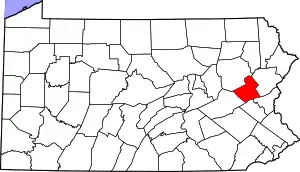 | |
| Townships | ||
| CDPs | ||
| Unincorporated communities | ||
| Footnotes | ‡This populated place also has portions in an adjacent county or counties | |
| ||
Municipalities and communities of Monroe County, Pennsylvania, United States | ||
|---|---|---|
| Boroughs | 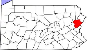 | |
| Townships | ||
| CDPs | ||
| Unincorporated communities |
| |
| Footnotes | ‡This populated place also has portions in an adjacent county | |
| ||