Monroe County, Pennsylvania
Monroe County is a county in the U.S. Commonwealth of Pennsylvania. As of the 2010 census, the population was 169,842.[2] Its county seat is Stroudsburg.[3] The county was formed from sections of Northampton and Pike counties.[4] Named in honor of James Monroe, the fifth president of the United States, the county is located in northeastern Pennsylvania, along its border with New Jersey. Monroe County is coterminous with the East Stroudsburg, PA Metropolitan Statistical Area. It also borders the Lehigh Valley and has connections to the Delaware Valley, being a part of Philadelphia's Designated Media Market.
Monroe County | |
|---|---|
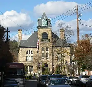 Monroe County Courthouse | |
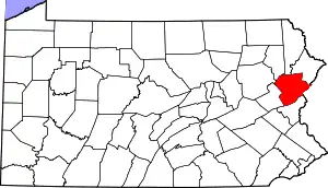 Location within the U.S. state of Pennsylvania | |
 Pennsylvania's location within the U.S. | |
| Coordinates: 41°04′N 75°20′W | |
| Country | |
| State | |
| Founded | April 1, 1836 |
| Named for | James Monroe[1] |
| Seat | Stroudsburg |
| Largest borough | East Stroudsburg |
| Area | |
| • Total | 617 sq mi (1,600 km2) |
| • Land | 608 sq mi (1,570 km2) |
| • Water | 9.0 sq mi (23 km2) 1.5%% |
| Population | |
| • Estimate (2019) | 170,271 |
| • Density | 279/sq mi (108/km2) |
| Time zone | UTC−5 (Eastern) |
| • Summer (DST) | UTC−4 (EDT) |
| Congressional districts | 7th, 8th |
| Website | http://www.monroecountypa.gov |
The county is home to East Stroudsburg University. For many recent decades, Monroe County was one of the fastest-growing counties in the state of Pennsylvania, partially due to tourism. The population increased by over 70% from 1990 to 2010, and the commercial and retail sectors expanded significantly, although population growth has since slowed.
Geography
According to the U.S. Census Bureau, the county has a total area of 617 square miles (1,600 km2), of which 608 square miles (1,570 km2) is land and 9.0 square miles (23 km2) (1.5%) is water.[5] It has a humid continental climate (Dfb except for some Dfa in the southern and SE tiers) and the hardiness zone ranges from 5a to 6b. The area code is 570, except in the southwest where the Kunkletown exchange uses 610.
Adjacent counties
- Wayne County (north)
- Pike County (northeast)
- Sussex County, New Jersey (northeast)
- Warren County, New Jersey (east)
- Northampton County (south)
- Carbon County (west)
- Luzerne County (northwest)
- Lackawanna County (northwest)
National protected areas
Demographics
As of the census[6] of 2010, there were 169,842 people, 49,454 households, and 36,447 families residing in the county. The population density was 228 people per square mile (88/km2). There were 67,581 housing units at an average density of 111 per square mile (43/km2). The racial makeup of the county was 70.5% White Non-Hispanic, 13.2% Black or African American, 0.3% Native American, 2.1% Asian, 0.03% Pacific Islander, 4.3% from other races, and 2.9% from two or more races. 13.1% of the population were Hispanic or Latino of any race. 19.9% were of German, 16.8% Irish, 14.5% Italian, 8.8% Pennsylvania German, 5.4% Polish, 5.1% American and 5.1% English ancestry.
There were 49,454 households, out of which 36.20% had children under the age of 18 living with them, 60.70% were married couples living together, 8.80% had a female householder with no husband present, and 26.30% were non-families. 20.20% of all households were made up of individuals, and 7.80% had someone living alone who was 65 years of age or older. The average household size was 2.73 and the average family size was 3.16.
In the county, the population was spread out, with 26.80% under the age of 18, 8.60% from 18 to 24, 28.80% from 25 to 44, 23.50% from 45 to 64, and 12.30% who were 65 years of age or older. The median age was 37 years. For every 100 females there were 97.60 males. For every 100 females age 18 and over, there were 94.40 males.
Metropolitan Statistical Area
The United States Office of Management and Budget has designated Monroe County of Pennsylvania as the East Stroudsburg, PA Metropolitan Statistical Area.[7] As of the 2010 census the Metro area had a population of 169,842. The area ranks 12th most populous in the state of Pennsylvania and ranks 244th most populous in the United States.
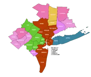
The United States Office of Management and Budget also has designated Monroe County as part of the larger New York–Newark, NY–NJ–CT–PA Combined Statistical Area.[7] The larger combined area consists of the Lehigh Valley counties of Carbon, Lehigh and Northampton as well as Pike County in Pennsylvania, and several other Metro areas from the States of New Jersey and New York. As of the 2010 US Census, the population of the CSA was 23,076,664, making it the most populous Combined Statistical Area in the United States.
Politics
For much of the second half of the 20th century, Monroe County was a Republican stronghold. However, in recent years, party registration has leaned toward the Democratic Party, a result of continued migration to the county by former New York City residents, many of whom are Democrats. While in the 2004 U.S. presidential election the county was carried by Republican George W. Bush by a margin of four votes, beginning with the first campaign (2008) of Barack Obama Democratic candidates carried Monroe County. In that election Obama carried the county by a 17-point margin, 58% to 41%–the first Democrat to win the county since 1964, and only the second since 1940. The other three 2008 statewide Democratic candidates also carried the county handily. Additionally, the Democratic presidential candidates carried the county in 2012 (Obama), 2016 (Hillary Clinton), and 2020 (Joe Biden).
| Year | Republican | Democratic | Third parties |
|---|---|---|---|
| 2020 | 46.1% 38,726 | 52.4% 44,060 | 1.5% 1,248 |
| 2016 | 47.7% 33,386 | 48.5% 33,918 | 3.9% 2,704 |
| 2012 | 42.6% 26,867 | 55.9% 35,221 | 1.5% 935 |
| 2008 | 41.2% 28,293 | 57.5% 39,453 | 1.3% 872 |
| 2004 | 49.7% 27,971 | 49.6% 27,967 | 0.7% 404 |
| 2000 | 49.6% 23,265 | 46.8% 21,939 | 3.6% 1,674 |
| 1996 | 44.4% 17,326 | 42.4% 16,547 | 13.3% 5,192 |
| 1992 | 38.8% 14,557 | 35.9% 13,468 | 25.3% 9,475 |
| 1988 | 62.8% 17,185 | 36.0% 9,859 | 1.2% 327 |
| 1984 | 65.8% 16,109 | 33.5% 8,193 | 0.7% 172 |
| 1980 | 55.4% 12,357 | 33.9% 7,551 | 10.7% 2,381 |
| 1976 | 50.7% 10,228 | 47.3% 9,544 | 2.0% 393 |
| 1972 | 67.5% 12,701 | 29.9% 5,619 | 2.6% 494 |
| 1968 | 53.3% 9,465 | 39.1% 6,946 | 7.5% 1,336 |
| 1964 | 36.9% 6,281 | 62.4% 10,622 | 0.7% 116 |
| 1960 | 63.7% 11,299 | 35.6% 6,312 | 0.7% 115 |
| 1956 | 64.3% 10,081 | 35.1% 5,506 | 0.6% 92 |
| 1952 | 62.1% 9,502 | 37.6% 5,760 | 0.3% 42 |
| 1948 | 53.0% 6,674 | 47.0% 5,913 | |
| 1944 | 52.9% 6,202 | 46.8% 5,490 | 0.3% 37 |
| 1940 | 47.3% 6,001 | 52.6% 6,670 | 0.1% 16 |
| 1936 | 41.0% 5,778 | 58.3% 8,212 | 0.6% 89 |
| 1932 | 41.6% 4,659 | 56.8% 6,357 | 1.6% 183 |
| 1928 | 69.4% 7,469 | 30.4% 3,266 | 0.3% 27 |
| 1924 | 44.3% 3,462 | 49.9% 3,901 | 5.8% 456 |
| 1920 | 48.0% 3,278 | 49.7% 3,396 | 2.3% 154 |
| 1916 | 29.8% 1,456 | 68.5% 3,348 | 1.7% 82 |
| 1912 | 11.6% 536 | 67.5% 3,107 | 20.9% 961 |
| 1908 | 31.6% 1,454 | 65.3% 3,004 | 3.1% 141 |
| 1904 | 34.5% 1,446 | 61.7% 2,587 | 3.9% 163 |
| 1900 | 28.0% 1,264 | 67.6% 3,054 | 4.4% 198 |
| 1896 | 31.8% 1,447 | 63.4% 2,887 | 4.8% 217 |
| 1892 | 24.5% 1,020 | 74.0% 3,078 | 1.5% 61 |
| 1888 | 25.0% 1,107 | 73.8% 3,274 | 1.3% 56 |
| 1884 | 23.6% 1,009 | 75.8% 3,242 | 0.6% 27 |
| 1880 | 22.3% 962 | 77.3% 3,334 | 0.4% 18 |
As of December 2019, there are 108,196 registered voters in Monroe County.
- Democratic: 50,438 (46.62%)
- Republican: 36,302 (33.55%)
- No affiliation/other: 21,456 (19.83%)
County commissioners
- Sharon Laverdure (D), Chair
- John Moyer (R), Vice Chair
- John Christy (D), Commissioner
Other county offices
- Controller, Marlo Merhige, Republican
- Coroner, Thomas Yanac, Democratic
- District Attorney, E. David Christine, Jr., Republican
- Prothonotary, George Warden, Republican
- Recorder of Deeds and Register of Wills, Josephine Ferro, Republican
- Sheriff, Ken Morris, Republican
- Treasurer, Theresa Johnson, Republican
State Representatives[9]
- Maureen Madden, Democratic, 115th district
- Jack Rader, Jr., Republican, 176th district
- Rosemary Brown, Republican, 189th district[10]
| Historical population | |||
|---|---|---|---|
| Census | Pop. | %± | |
| 1840 | 9,879 | — | |
| 1850 | 13,270 | 34.3% | |
| 1860 | 16,758 | 26.3% | |
| 1870 | 18,362 | 9.6% | |
| 1880 | 20,175 | 9.9% | |
| 1890 | 20,111 | −0.3% | |
| 1900 | 21,161 | 5.2% | |
| 1910 | 22,941 | 8.4% | |
| 1920 | 24,295 | 5.9% | |
| 1930 | 28,286 | 16.4% | |
| 1940 | 29,802 | 5.4% | |
| 1950 | 33,773 | 13.3% | |
| 1960 | 39,567 | 17.2% | |
| 1970 | 45,422 | 14.8% | |
| 1980 | 69,409 | 52.8% | |
| 1990 | 95,709 | 37.9% | |
| 2000 | 138,687 | 44.9% | |
| 2010 | 169,842 | 22.5% | |
| 2019 (est.) | 170,271 | [11] | 0.3% |
| U.S. Decennial Census[12] 1790-1960[13] 1900-1990[14] 1990-2000[15] 2010-2019[2] | |||
State Senators
- John P. Blake, Democratic, 22nd District
- Mario Scavello, Republican, 40th district
United States Representatives
- Susan Wild, Democratic, Pennsylvania's 7th congressional district
- Matthew Cartwright, Democratic, Pennsylvania's 8th congressional district
United States Senators
- Robert P. Casey, Jr., Democratic
- Pat Toomey, Republican
Governor
- Tom Wolf, Democratic
Transportation
Public transportation throughout the county is provided by the Monroe County Transit Authority (MCTA), known as the "Pocono Pony".[16] MCTA operates a fixed route bus system[17] and a paratransit curb to curb service for eligible populations.[18]
New Jersey Transit is restoring train tracks in northwestern New Jersey along the Lackawanna Cut-off. This would, potentially, also involve the train to go to Scranton from Hoboken (which would go through the Poconos), marking the first time since the early 1970s when the Erie Lackawanna Railroad stopped running daily trains through the area.
Education
Colleges and universities
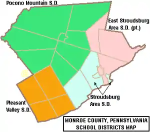
Public school districts
Charter schools
- Evergreen Community Charter School, Cresco
- Pocono Mountain Charter School, Tobyhanna, **charter revoked by PDE 2014**[19]
Technology schools
Private schools
- Art Learning Center, East Stroudsburg
- Character Builders Christian Academy, Pocono Pines
- East Stroudsburg Christian Academy, East Stroudsburg **closed in 2012**
- Monsignor McHugh School, Cresco **closed in 2020**
- Notre Dame Elementary School, East Stroudsburg
- Notre Dame High School, East Stroudsburg
- Pocono Central Catholic High School, Cresco **closed in 1988**
- St Pauls Lutheran Pre-School, East Stroudsburg
- Stroudsburg 7th Day Adventists School, Stroudsburg
- Summit School of the Poconos, Stroudsburg
- Triumphant & Excellence Academy 1, East Stroudsburg
- Triumphant & Excellence Academy 2 TEA Institute, Tobyhanna
- Triumphant Living Heritage, Marshalls Creek
- Victory Baptist Christian School, Brodheadsville
Private schools are as reported in EdNA school database maintained and published by the Pennsylvania Department of Education, 2011
Industry
The Tobyhanna Army Depot, the US Department of Defense's largest center for the repair and fabrication of electronic systems, is located in Monroe County.[20] It was identified in 2004 as the largest employer in northeastern Pennsylvania.[21]
The US headquarters for Sanofi Pasteur, a vaccine manufacturer, is also in Monroe County.[22] The facility was originally established in 1897 by Brooklyn native Richard M. Slee as the Pocono Biological Laboratories. It was the first and only company in the United States to produce a new glycerolized smallpox vaccine from France and, in 1898, it provided all of the vaccines used in Cuba during the Spanish–American War.[23]
Parks and Trails

The Delaware Water Gap National Recreation Area, which "includes nearly 70,000 acres of mountains, valleys and floodplains," is partially located in Monroe County.[24] The county also has Pennsylvania state parks, such as Big Pocono State Park and parts of the Delaware State Forest, Gouldsboro State Park, and Tobyhanna State Park.[25]
The Appalachian Trail passes through Monroe County. David Pierce wrote in the Pocono Record, "The 2,184-mile public footpath—from Georgia to Maine—has a particularly scenic but rugged section that straddles Monroe County’s southern border..." He stated that "trail hiking has long been an integral part of Monroe County's identity..."[26]
During the Revolutionary War in 1779, General John Sullivan marched his troops through Monroe County on their expedition to fight the Iroquois tribe in New York State.[27] There are many historical markers identifying the Sullivan Trail.[28] Sergeant Moses Fellows of the Third New Hampshire Regiment described the area as "...very poor & Barren and I think as never will Be Settled.”[29]
Resorts

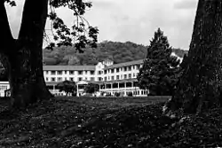
Two of the earliest Pocono resorts, founded by rival factions of the Philadelphia Quaker community, were located in Monroe County: Inn at Buck Hill Falls (1901) and Pocono Manor (1902).[30][31][32] These resorts did not allow liquor or dancing, and evening dress was discouraged.[33] The Quakers "brought a quiet, unostentatious style to the region,"[33] but their hotels later developed from religious retreats into "luxurious mountain resorts."[34] Buck Hill's stone facade became a model for close to 300 stately stone-and-shingle homes in the region.[33] Pocono Manor offers sweeping vistas of the eastern and western Pocono region and has been referred to as the "Grand Lady of the Mountains."[35] Buck Hill closed in 1990 and the Inn at Pocono Manor was mostly destroyed by fire in 2019.[33][36]
Skytop Lodge, built in 1928, is also located in Monroe County and has been described as a "Dutch Colonial-style manor house."[32][37] Designed in reaction to the Quaker resorts, it had a dance floor and served liquor in a basement bar.[33] Skytop offers thirty miles of hiking trails, and the main building "is surrounded by 5,000 acres of wood, glacial bogs, hemlock gorges, beaver marshes, and cascading waterfalls."[35]
The Buckwood Inn opened in Monroe County in 1911 and included the first golf course to be designed by renowned golf architect A. W. Tillinghast.[38][39][40] Bandleader Fred Waring purchased the resort in 1943, renamed it the Shawnee Inn, and broadcast his radio shows from there.[41] The Shawnee Inn is a Spanish colonial revival building with white-Moorish architecture and Spanish tiled roofs,[33] and it was identified in the 1990s as the only resort on the banks of the Delaware River.[42][43]
Mount Airy Lodge, which expanded from an eight-room inn into the largest Pocono resort, was located in Monroe County.[44][45] It heavily advertised in the New York media market with the catchy jingle, "Beautiful Mount Airy Lodge."[46] Headliners, such as Bob Hope, Milton Berle, and Connie Francis, performed in the Crystal Room, Mount Airy's 2,000-seat theater. Comedian Mickey Freeman said, "The food was lousy, but it was a legalized orgy." The 1,200 acre resort's heyday was in the 1960s and 1970s before closing in 2001.[45] In October 2007 the Mount Airy Casino Resort opened on the site.[44]
As of July 2015, there were three resorts in Monroe County with indoor water parks: Great Wolf Lodge, Aquatopia at Camelback Resort, and Kalahari Resort.[47]
Communities
Under Pennsylvania law, there are four types of incorporated municipalities: cities, boroughs, townships, and, in at most two cases, towns. The following cities, boroughs and townships are located in Monroe County:
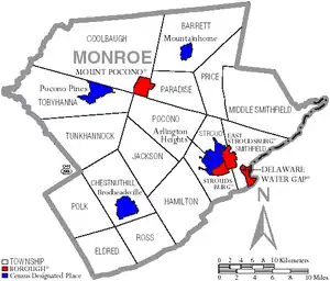
Boroughs
- Delaware Water Gap
- East Stroudsburg
- Mount Pocono
- Stroudsburg (county seat)
Townships
Census-designated places
Census-designated places are geographical areas designated by the U.S. Census Bureau for the purposes of compiling demographic data. They are not actual jurisdictions under Pennsylvania law.
Unincorporated communities
- Analomink
- Appenzell
- Bartonsville
- Blakeslee
- Bossardsville
- Canadensis
- Cherry Valley
- Cresco
- Gilbert
- Gravel Place
- Hamilton Square
- Henryville
- Jonas
- Kellersville
- Kemmertown
- Kresgeville
- Kunkletown
- Long Pond
- Marshalls Creek
- McIlhaney
- McMichaels
- Meistertown
- Neola
- Paradise Valley
- Pocono Manor
- Pocono Summit
- Reeders
- Sciota
- Scotrun
- Shawnee on Delaware
- Skytop
- Snydersvillle
- South Stroudsburg
- Swiftwater
- Tannersville
- Tobyhanna
Population ranking
The population ranking of the following table is based on the 2010 census of Monroe County.[48]
† county seat
| Rank | City/Town/etc. | Municipal type | Population (2010 Census) |
|---|---|---|---|
| 1 | East Stroudsburg | Borough | 9,840 |
| 2 | Arlington Heights | CDP | 6,333 |
| 3 | † Stroudsburg | Borough | 5,567 |
| 4 | Sierra View | CDP | 4,813 |
| 5 | Penn Estates | CDP | 4,493 |
| 6 | Indian Mountain Lake (partially in Carbon County) | CDP | 4,372 |
| 7 | Saw Creek (mostly in Pike County) | CDP | 4,016 |
| 8 | Mount Pocono | Borough | 3,170 |
| 9 | Emerald Lakes | CDP | 2,886 |
| 10 | Sun Valley | CDP | 2,399 |
| 11 | Effort | CDP | 2,269 |
| 12 | Brodheadsville | CDP | 1,800 |
| 13 | Pocono Pines | CDP | 1,409 |
| 14 | Mountainhome | CDP | 1,182 |
| 15 | Saylorsburg | CDP | 1,126 |
| 16 | Gouldsboro (mostly in Wayne County) | CDP | 890 |
| 17 | Delaware Water Gap | Borough | 746 |
Climate
Pocono Plateau Region
According to the Trewartha climate classification system, the higher elevation Pocono Plateau Region of Monroe County has a Temperate Continental climate (Dc) with warm summers (b), cold winters (o) and year-around precipitation (Dcbo). Dcbo climates are characterized by at least one month having an average mean temperature ≤ 32.0 °F (0.0 °C), four to seven months with an average mean temperature ≥ 50.0 °F (10.0 °C), all months with an average mean temperature < 72.0 °F (22.2 °C) and no significant precipitation difference between seasons. Although most summer days are comfortably humid on the Pocono Plateau, episodes of heat and high humidity can occur with heat index values > 92 °F (33 °C). Since 1981, the highest air temperature was 93.0 °F (33.9 °C) on 07/15/1995, and the highest daily average mean dew point was 70.8 °F (21.6 °C) on 08/01/2006. July is the peak month for thunderstorm activity which correlates with the average warmest month of the year. Since 1981, the wettest calendar day was 6.43 inches (163 mm) on 09/30/2010. During the winter months, the plant hardiness zone is 5b with an average annual extreme minimum air temperature of −11.2 °F (−24.0 °C).[49] Since 1981, the coldest air temperature was −22.9 °F (−30.5 °C) on 01/21/1994. Episodes of extreme cold and wind can occur with wind chill values < −24 °F (−31 °C). The average snowiest month is January which correlates with the average coldest month of the year. Ice storms and large snowstorms depositing ≥ 12 inches (30 cm) of snow occur nearly every year, particularly during nor’easters from December through March.
| Climate data for 4 NE Tobyhanna, Elevation 2,087 ft (636 m), 1981-2010 normals, extremes 1981-2018 | |||||||||||||
|---|---|---|---|---|---|---|---|---|---|---|---|---|---|
| Month | Jan | Feb | Mar | Apr | May | Jun | Jul | Aug | Sep | Oct | Nov | Dec | Year |
| Record high °F (°C) | 60.9 (16.1) |
71.1 (21.7) |
80.3 (26.8) |
86.4 (30.2) |
88.9 (31.6) |
88.5 (31.4) |
93.0 (33.9) |
91.5 (33.1) |
89.1 (31.7) |
81.4 (27.4) |
74.8 (23.8) |
65.2 (18.4) |
93.0 (33.9) |
| Average high °F (°C) | 29.9 (−1.2) |
33.3 (0.7) |
41.6 (5.3) |
54.3 (12.4) |
65.4 (18.6) |
73.2 (22.9) |
77.5 (25.3) |
76.0 (24.4) |
68.9 (20.5) |
57.3 (14.1) |
46.1 (7.8) |
34.3 (1.3) |
54.9 (12.7) |
| Daily mean °F (°C) | 21.9 (−5.6) |
25.0 (−3.9) |
32.3 (0.2) |
44.6 (7.0) |
55.2 (12.9) |
63.5 (17.5) |
68.1 (20.1) |
66.8 (19.3) |
59.8 (15.4) |
48.4 (9.1) |
38.5 (3.6) |
27.3 (−2.6) |
46.0 (7.8) |
| Average low °F (°C) | 13.9 (−10.1) |
16.6 (−8.6) |
23.0 (−5.0) |
34.8 (1.6) |
45.0 (7.2) |
53.8 (12.1) |
58.7 (14.8) |
57.6 (14.2) |
50.7 (10.4) |
39.5 (4.2) |
30.9 (−0.6) |
20.3 (−6.5) |
37.2 (2.9) |
| Record low °F (°C) | −22.9 (−30.5) |
−14.1 (−25.6) |
−9.0 (−22.8) |
10.7 (−11.8) |
27.5 (−2.5) |
33.2 (0.7) |
38.1 (3.4) |
34.3 (1.3) |
28.2 (−2.1) |
17.9 (−7.8) |
−0.7 (−18.2) |
−16.2 (−26.8) |
−22.9 (−30.5) |
| Average precipitation inches (mm) | 3.66 (93) |
3.31 (84) |
4.27 (108) |
4.54 (115) |
4.67 (119) |
5.13 (130) |
4.78 (121) |
4.32 (110) |
5.14 (131) |
5.31 (135) |
4.44 (113) |
4.25 (108) |
53.82 (1,367) |
| Average snowfall inches (cm) | 20.9 (53) |
15.0 (38) |
15.6 (40) |
3.7 (9.4) |
0.0 (0.0) |
0.0 (0.0) |
0.0 (0.0) |
0.0 (0.0) |
0.0 (0.0) |
0.1 (0.25) |
3.9 (9.9) |
12.5 (32) |
71.7 (182) |
| Average relative humidity (%) | 76.0 | 70.3 | 66.5 | 62.3 | 64.9 | 74.1 | 74.0 | 77.1 | 78.5 | 75.2 | 74.2 | 77.8 | 72.6 |
| Average dew point °F (°C) | 15.5 (−9.2) |
16.7 (−8.5) |
22.4 (−5.3) |
32.5 (0.3) |
43.6 (6.4) |
55.1 (12.8) |
59.5 (15.3) |
59.4 (15.2) |
53.1 (11.7) |
40.9 (4.9) |
31.0 (−0.6) |
21.3 (−5.9) |
37.7 (3.2) |
| Source: PRISM[50] | |||||||||||||
Ridge and Valley Region
According to the Trewartha climate classification system, the lower elevation Ridge and Valley section of Monroe County has a Temperate Continental climate (Dc) with hot summers (a), cold winters (o) and year-around precipitation (Dcao). Dcao climates are characterized by at least one month having an average mean temperature ≤ 32.0 °F (0.0 °C), four to seven months with an average mean temperature ≥ 50.0 °F (10.0 °C), at least one month with an average mean temperature ≥ 72.0 °F (22.2 °C) and no significant precipitation difference between seasons. Although most summer days are slightly humid in the Ridge and Valley, episodes of heat and high humidity can occur with heat index values > 102 °F (39 °C). Since 1981, the highest air temperature was 100.3 °F (37.9 °C) on 07/22/2011, and the highest daily average mean dew point was 72.7 °F (22.6 °C) on 08/01/2006. July is the peak month for thunderstorm activity which correlates with the average warmest month of the year. The average wettest month is September which correlates with tropical storm remnants during the peak of the Atlantic hurricane season. Since 1981, the wettest calendar day was 6.36 inches (162 mm) on 10/08/2005. During the winter months, the plant hardiness zone is 6a with an average annual extreme minimum air temperature of −5.4 °F (−20.8 °C).[49] Since 1981, the coldest air temperature was −18.0 °F (−27.8 °C) on 01/21/1994. Episodes of extreme cold and wind can occur with wind chill values < −17 °F (−27 °C). The average snowiest month is January which correlates with the average coldest month of the year. Ice storms and large snowstorms depositing ≥ 12 inches (30 cm) of snow occur once every couple of years, particularly during nor’easters from December through March.
| Climate data for East Stroudsburg, Elevation 531 ft (162 m), 1981-2010 normals, extremes 1981-2018 | |||||||||||||
|---|---|---|---|---|---|---|---|---|---|---|---|---|---|
| Month | Jan | Feb | Mar | Apr | May | Jun | Jul | Aug | Sep | Oct | Nov | Dec | Year |
| Record high °F (°C) | 68.6 (20.3) |
77.0 (25.0) |
86.3 (30.2) |
94.4 (34.7) |
94.5 (34.7) |
95.3 (35.2) |
100.3 (37.9) |
98.7 (37.1) |
96.3 (35.7) |
87.9 (31.1) |
79.5 (26.4) |
71.1 (21.7) |
100.3 (37.9) |
| Average high °F (°C) | 36.1 (2.3) |
39.8 (4.3) |
48.8 (9.3) |
61.6 (16.4) |
71.9 (22.2) |
79.9 (26.6) |
83.9 (28.8) |
82.3 (27.9) |
75.1 (23.9) |
63.6 (17.6) |
52.3 (11.3) |
40.4 (4.7) |
61.4 (16.3) |
| Daily mean °F (°C) | 27.0 (−2.8) |
29.9 (−1.2) |
37.9 (3.3) |
49.2 (9.6) |
59.3 (15.2) |
68.0 (20.0) |
72.4 (22.4) |
70.9 (21.6) |
63.5 (17.5) |
51.9 (11.1) |
42.3 (5.7) |
31.9 (−0.1) |
50.4 (10.2) |
| Average low °F (°C) | 17.9 (−7.8) |
20.1 (−6.6) |
27.0 (−2.8) |
36.9 (2.7) |
46.7 (8.2) |
56.1 (13.4) |
60.9 (16.1) |
59.5 (15.3) |
51.9 (11.1) |
40.3 (4.6) |
32.3 (0.2) |
23.4 (−4.8) |
39.5 (4.2) |
| Record low °F (°C) | −18.0 (−27.8) |
−8.6 (−22.6) |
−0.5 (−18.1) |
14.3 (−9.8) |
27.1 (−2.7) |
36.4 (2.4) |
42.6 (5.9) |
38.0 (3.3) |
29.8 (−1.2) |
19.8 (−6.8) |
6.1 (−14.4) |
−7.1 (−21.7) |
−18.0 (−27.8) |
| Average precipitation inches (mm) | 3.40 (86) |
2.97 (75) |
3.64 (92) |
4.11 (104) |
4.43 (113) |
4.48 (114) |
4.52 (115) |
4.41 (112) |
4.97 (126) |
4.77 (121) |
4.02 (102) |
4.09 (104) |
49.81 (1,265) |
| Average snowfall inches (cm) | 11.8 (30) |
8.5 (22) |
8.8 (22) |
2.1 (5.3) |
0.0 (0.0) |
0.0 (0.0) |
0.0 (0.0) |
0.0 (0.0) |
0.0 (0.0) |
0.1 (0.25) |
2.2 (5.6) |
7.1 (18) |
40.6 (103) |
| Average relative humidity (%) | 69.1 | 64.3 | 59.6 | 57.4 | 61.8 | 68.9 | 68.9 | 71.7 | 72.8 | 71.0 | 69.4 | 70.5 | 67.1 |
| Average dew point °F (°C) | 18.2 (−7.7) |
19.3 (−7.1) |
25.1 (−3.8) |
34.8 (1.6) |
46.2 (7.9) |
57.4 (14.1) |
61.6 (16.4) |
61.3 (16.3) |
54.6 (12.6) |
42.8 (6.0) |
33.0 (0.6) |
23.4 (−4.8) |
39.9 (4.4) |
| Source: PRISM[50] | |||||||||||||
Ecology
Pocono Plateau Region
According to the A. W. Kuchler U.S. potential natural vegetation types, the higher elevation Pocono Plateau Region of Monroe County would have a dominant vegetation type of Northern Hardwood (106) with a dominant vegetation form of Northern hardwood forest (26).[51] The peak spring bloom typically occurs in early-May and peak fall color usually occurs in early-October. The plant hardiness zone is 5b with an average annual extreme minimum air temperature of −11.2 °F (−24.0 °C).[49]
Ridge and Valley Region
According to the A. W. Kuchler U.S. potential natural vegetation types, the lower elevation Ridge and Valley section of Monroe County would have a dominant vegetation type of Appalachian Oak (104) with a dominant vegetation form of Eastern Hardwood Forest (25).[51] The peak spring bloom typically occurs in late-April and peak fall color usually occurs in mid-October. The plant hardiness zone is 6a with an average annual extreme minimum air temperature of −5.4 °F (−20.8 °C).[49]
References
- Gannett, Henry (1905). The Origin of Certain Place Names in the United States. U.S. Government Printing Office. p. 212.
- "State & County QuickFacts". United States Census Bureau. Archived from the original on June 6, 2011. Retrieved November 20, 2013.
- "Find a County". National Association of Counties. Retrieved 2011-06-07.
- "Monroe County, Pennsylvania" (PDF). monroecountypa.gov. Retrieved 2018-11-27.
- "2010 Census Gazetteer Files". United States Census Bureau. August 22, 2012. Retrieved March 9, 2015.
- "U.S. Census website". United States Census Bureau. Retrieved 2008-01-31.
- "Archived copy" (PDF). Archived from the original (PDF) on 2016-11-10. Retrieved 2016-05-11.CS1 maint: archived copy as title (link)
- Leip, David. "Dave Leip's Atlas of U.S. Presidential Elections". uselectionatlas.org. Retrieved 27 November 2018.
- Center, Legislativate Data Processing. "Find Your Legislator". The official website for the Pennsylvania General Assembly. Retrieved 2017-04-25.
- Center, Legislativate Data Processing. "Find Your Legislator". The official website for the Pennsylvania General Assembly. Retrieved 27 November 2018.
- "Population and Housing Unit Estimates". Retrieved May 21, 2020.
- "U.S. Decennial Census". United States Census Bureau. Retrieved March 9, 2015.
- "Historical Census Browser". University of Virginia Library. Retrieved March 9, 2015.
- Forstall, Richard L., ed. (March 24, 1995). "Population of Counties by Decennial Census: 1900 to 1990". United States Census Bureau. Retrieved March 9, 2015.
- "Census 2000 PHC-T-4. Ranking Tables for Counties: 1990 and 2000" (PDF). United States Census Bureau. April 2, 2001. Retrieved March 9, 2015.
- Monroe County Transit Authority. Gomcta.com. Retrieved on 2013-08-09.
- Pocono Pony Bus Routes. Gomcta.com (2013-06-08). Retrieved on 2013-08-09.
- Monroe County Transportation Authority, The Pocono Pony's Shared Ride Service. Gomcta.com. Retrieved on 2013-08-09.
- Jenna Ebersole (June 5, 2014). "Pocono Mountain Charter School's charter revoked". Pocono Record.
- Soper, Spencer (October 20, 2010). "Tobyhanna Army Depot to cut 189 jobs". The Morning Call. Allentown, Pennsylvania. Retrieved December 21, 2020.
- Slade, David (July 9, 2004). "Bittersweet victory for depot staff". The Morning Call. Allentown, Pennsylvania. Retrieved December 21, 2020.
- Herzog, Amy (December 11, 2016). "No recall for glass found in vaccine". The Morning Call. Allentown, Pennsylvania. Retrieved December 21, 2020.
- Leiser, Amy. "Swiftwater laboratory starts with Col. Slee". Monroe County Historical Association. Retrieved October 9, 2018.
- Kohler, Aimee. "Pocono Photo Tour: Delaware Water Gap National Recreation Area". Pocono Mountains Visitors Bureau. Retrieved October 4, 2018.
- "State & National Parks & Forests in Pocono Mountains PA". VisitPA.com. Commonwealth of Pennsylvania Department of Community and Economic Development. Retrieved October 4, 2018.
- Pierce, David (September 17, 2015). "31 Things That Play in the Poconos: Appalachian Trail beckons local and through hikers". Pocono Record. Stroudsburg, Pennsylvania. Retrieved October 5, 2018.
- Heffelfinger, Bill (January 14, 1968). "'Sullivan's Trail' Truly Historic". The Morning Call. Allentown, Pennsylvania. Retrieved December 21, 2020.
- Amaral, Brian. "CDs lead cars along truly historic Sullivan Trail". Monroe County Historical Association. Retrieved October 5, 2018.
- Mintz, Max (1999). Seeds of Empire. New York: New York University Press. p. 96. ISBN 0-8147-5622-0.
- Squeri, Lawrence (2002). Better in the Poconos: The Story of Pennsylvania's Vacationland. University Park, PA: Pennsylvania State University Press. pp. 71–73. ISBN 0271021578.
- "Corvelle named assistant GM at Pocono Manor". Pocono Record. Stroudsburg, Pennsylvania. October 11, 2009. Retrieved September 18, 2015.
- "Nearly Million Surgical Dressings Made by Units Soon to Stop Work". The Morning Call. Allentown, Pennsylvania. July 31, 1945. Retrieved December 21, 2020.
- Fleeson, Lucinda (September 2, 1994). "Fading Memories In The Poconos". The Philadelphia Inquirer. Retrieved December 21, 2020.
- Uguccioni, Marilyn (May 29, 1976). "Resort industry old-timer in the Pocono Mountains". The Pocono Record. Retrieved December 21, 2020.
- Sulon, Bill (February 6, 2003). "Cold comfort: a trio of Pennsylvania inns". The Baltimore Sun. Retrieved December 21, 2020.
- Scott, Andrew; Sigafoos, Stephanie (November 1, 2019). "'This is heartbreaking': Wind-whipped fire destroys 117-year-old Pocono Manor resort in Monroe County". The Morning Call. Allentown, PA. Retrieved January 14, 2019.
- "Skytop Lodge". Historic Hotels of America. National Trust For Historic Preservation. Retrieved October 3, 2015.
- Goodwin, Stephen; Wolffe, Rick. "The Creator of Golf Courses". The Tillinghast Association. Retrieved September 19, 2018.
- Jesky, Mike (October 26, 1997). "Shawnee Inn: It's stately, yet inviting". Standard Speaker. Hazleton, PA. Retrieved December 21, 2020.
- Edelson, Stephen (September 2, 1999). "A Guide To The Best In Fall Golfing". Asbury Park Press. Asbury Park, New Jersey. Retrieved December 21, 2020.
- Squeri (2002), p. 182
- Fodor's national parks and seashores of the east (1 ed.). New York: Fodor's Travel Publications. 1994. p. 164.
- Shea, Barbara (September 11, 1994). "Let the current set the pace at the Delaware Water Gap". The Courier-News. Somerville, NJ. Retrieved December 21, 2020.
- McKinley, Jesse; Bagli, Charles (November 6, 2014). "In Faded Vacationland, Gambling's Promise Falls Short". New York Times. Retrieved October 8, 2015.
- Jacobs, Andrew (November 2, 2001). "The Thrills Are Over At Mount Airy Lodge". New York Times.
- Rubinkam, Michael (February 27, 2005). "For sale at Poconos lodge: The heart-shaped tub, and lots more". The Star-Democrat. Easton, Maryland. Retrieved December 21, 2020.
- Lauer-Williams, Kathy (July 19, 2015). "Water Park windfall". The Morning Call. Allentown, Pennsylvania. Retrieved December 21, 2020.
- US Census Bureau. "Decennial Census of Population and Housing--by Decade". www.census.gov. Retrieved 2018-11-27.
- "USDA Interactive Plant Hardiness Map". United States Department of Agriculture. Retrieved September 9, 2019.
- "PRISM Climate Group, Oregon State University". Retrieved September 9, 2019.
- "U.S. Potential Natural Vegetation, Original Kuchler Types, v2.0 (Spatially Adjusted to Correct Geometric Distortions)". Retrieved September 9, 2019.
Places adjacent to Monroe County, Pennsylvania | ||||||||||
|---|---|---|---|---|---|---|---|---|---|---|
| ||||||||||
Municipalities and communities of Monroe County, Pennsylvania, United States | ||
|---|---|---|
| Boroughs | | |
| Townships | ||
| CDPs | ||
| Unincorporated communities |
| |
| Footnotes | ‡This populated place also has portions in an adjacent county | |
| ||

| Authority control |
|---|