Iowa Highway 136
Iowa Highway 136 (Iowa 136) is a state highway maintained by the Iowa Department of Transportation. It runs for 98 miles (158 km) in eastern Iowa. It begins at the Mississippi River in Clinton on the Mark Morris Memorial Bridge, where it continues as Illinois Route 136. It ends at an intersection with U.S. Highway 52 and Iowa Highway 3 in Luxemburg. Although signed as a north–south highway throughout, the highway runs east to west between Clinton and Oxford Junction, while turning north at Oxford Junction to complete its run to Luxemburg. For most of its existence, Iowa 136 has connected Clinton and Luxemburg. During the 1950s-1960s, the northern and southern ends of the route shifted slightly because nearby United States highways changed their alignments.
| ||||
|---|---|---|---|---|
Iowa 136 highlighted in red | ||||
| Route information | ||||
| Maintained by Iowa DOT | ||||
| Length | 97.733 mi[1] (157.286 km) | |||
| Major junctions | ||||
| South end | ||||
| ||||
| North end | ||||
| Location | ||||
| Counties | ||||
| Highway system | ||||
| ||||

Route description
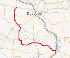
Iowa Highway 136 begins on the Mark Morris Memorial Bridge over the Mississippi River at Clinton. It descends the approach to the bridge and intersects U.S. Highway 67 (US 67), which is running along N. Second Street. It turns to the north, overlapping US 67 for 3⁄4 mile (1.2 km) until US 67 splits away at N. Third Street.[1] From US 67, Iowa 136 goes west along Main Avenue and leaves town enters rural Clinton County.[2] It heads to the north-northwest for 10 miles (16 km) towards Goose Lake along a narrow, curving stretch of road. In 2010, conditions along this part of Iowa 136 led some residents to create a page on the social networking website Facebook dedicated to calling attention to the road, and since then the route has been repaved.[3]
From Goose Lake, Iowa 136 continues to the west towards Delmar for 15 miles (24 km), passing through Charlotte along the way. Three miles (4.8 km) west of Delmar, it meets U.S. Highway 61 at a diamond interchange. This interchange is adjacent to the 61 Drive In outdoor movie theatre. It continues west through the small communities of Elwood and Lost Nation, before reaching Oxford Junction.[4]
At Oxford Junction, Iowa 136 turns to the north and travels 7 miles (11 km) to Wyoming, where it meets Iowa Highway 64. For one mile (1.6 km), Iowa 64 and Iowa 136 overlap each other through Wyoming. On the western edge of the community, Iowa 136 splits away and travels north towards Onslow. North of Onslow, it passes through rural Jones County for 15 miles (24 km), crossing the Maquoketa River, before reaching Cascade and U.S. Route 151.[1]
Now in Dubuque County, Iowa 136 crosses the North Fork Maquoketa River and heads northwest towards Worthington. Five miles (8.0 km) later, it meets U.S. Highway 20 and U.S. Highway 52 at a partial cloverleaf interchange south of Dyersville. From here, US 52 continues with Iowa 136 for the rest of its length. North of Dyersville, it travels north, through New Vienna, and to the northeast towards Luxemburg.[4] At Luxemburg, Iowa 136 and US 52 enter town along Andre Street. The route ends at an intersection with Iowa Highway 3. Northbound US 52 continues north along Andre Street, while both directions of Iowa 3 follow Main Street.[5]
History
In 1926, when Primary Road No. 20 (PR 20) was renamed U.S. Highway 61, Primary Road No. 61, which connected Clinton to US 61 west of Delmar, was renumbered Primary Road No. 136.[6] In 1930, Iowa Iowa 136 had been extended west and north to what is now Iowa 64, replacing Iowa 153. Iowa 136 extended north to Onslow in 1931, and to Cascade in 1935. In 1938, Iowa 136 had been extended to Luxemburg, replacing Iowa 188. By 1947, only the PR 61 section of road and another section between Wyoming and Oxford Junction had been paved.[7] In Clinton, Iowa 136 originally began at the N. Third Street intersection with U.S. Highway 67. After U.S. Highway 30 was rerouted over the Gateway Bridge in 1955, Iowa 136 was extended to cross the Mississippi River over the Lyons-Fulton Bridge.[8] A year later, an Alternate U.S. Route 30 was designated over the old alignment of US 30 through Clinton, and Iowa 136 was pulled back to its old end.[9] In 1967, the Alternate US 30 designation was dropped and Iowa 136 again crossed the river.[10]
From 1963 to 1967, U.S. Highway 52 was realigned from Dubuque to Luxemburg to follow U.S. Highway 20 to Dyersville and Iowa 136 to Luxemburg while its original alignment was rebuilt. During this time, Iowa 136 was truncated back to US 20 at Dyersville, but it was redesignated along this segment after US 52 returned to its old alignment.[11][12]
Major intersections
| County | Location | mi[1] | km | Destinations | Notes |
|---|---|---|---|---|---|
| Mississippi River | 0.000 | 0.000 | Continuation in Illinois | ||
| Mark Morris Memorial Bridge | |||||
| Clinton | Clinton | 0.465 | 0.748 | Southern end of US 67 overlap | |
| 1.123 | 1.807 | Northern end of US 67 overlap | |||
| Delmar | 30.427 | 48.968 | |||
| Jones | Wyoming | 53.962 | 86.843 | Southern end of Iowa 64 overlap | |
| 54.924 | 88.392 | Northern end of Iowa 64 overlap | |||
| Dubuque | Cascade | 73.528 | 118.332 | ||
| Dyersville | 87.611 | 140.996 | Southern end of US 52 overlap | ||
| Luxemburg | 97.733 | 157.286 | Northern end of US 52 overlap | ||
1.000 mi = 1.609 km; 1.000 km = 0.621 mi
| |||||
External links
References
- 2009 Volume of Traffic on the Primary Road System of Iowa (PDF) (Report). Iowa Department of Transportation. January 1, 2009. Retrieved August 17, 2010.
- Clinton (PDF) (Map). Iowa Department of Transportation. 2010. Retrieved August 24, 2010.
- "Fix Highway 136". Facebook. Retrieved August 24, 2010.
- Transportation Map (PDF) (Map). Iowa Department of Transportation. 2010. § L6:N4. Retrieved August 24, 2010.
- Highway and Street Map of Luxemburg, Iowa (PDF) (Map). Iowa Department of Transportation. May 18, 2009. Retrieved August 24, 2010.
- Junior Road Map: Eastern Iowa (Map). Rand McNally & Company. 1926. Retrieved August 24, 2010.
- Road and Reference Atlas (Map). 1:1,077,120. Rand McNally & Company. 1947. pp. 42–43. § D10:E12.
|access-date=requires|url=(help) - Iowa State Highway Map (PDF) (Map). Iowa State Highway Commission. 1956. Clinton inset. Retrieved August 24, 2010.
- Iowa State Highway Map (PDF) (Map). Iowa State Highway Commission. 1957. Clinton inset. Retrieved August 24, 2010.
- Iowa State Highway Map (PDF) (Map). Iowa State Highway Commission. 1968. Clinton inset. Retrieved August 24, 2010.
- Iowa State Highway Map (PDF) (Map). Iowa State Highway Commission. 1964. § F24. Retrieved August 24, 2010.
- Iowa State Highway Map (PDF) (Map). Iowa State Highway Commission. 1968. § F24. Retrieved August 24, 2010.