Clinton County, Iowa
Clinton County is a county located in the U.S. state of Iowa. As of the 2010 census, the population was 49,116.[1] Its county seat is Clinton.[2] Its name is in honor of the seventh Governor of New York State, DeWitt Clinton.
Clinton County | |
|---|---|
 | |
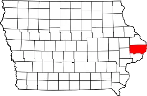 Location within the U.S. state of Iowa | |
 Iowa's location within the U.S. | |
| Coordinates: 41°53′34″N 90°31′39″W | |
| Country | |
| State | |
| Founded | 1837 |
| Named for | DeWitt Clinton |
| Seat | Clinton |
| Largest city | Clinton |
| Area | |
| • Total | 710 sq mi (1,800 km2) |
| • Land | 695 sq mi (1,800 km2) |
| • Water | 15 sq mi (40 km2) 2.1% |
| Population (2010) | |
| • Total | 49,116 |
| • Estimate (2018) | 46,518 |
| • Density | 69/sq mi (27/km2) |
| Time zone | UTC−6 (Central) |
| • Summer (DST) | UTC−5 (CDT) |
| Congressional district | 2nd |
| Website | www |
Clinton County comprises the Clinton, IA Micropolitan Statistical Area, which is also included in the Davenport–Moline–Rock Island Metropolitan Statistical Area.
History
Clinton County was formed on December 21, 1837. It was named for DeWitt Clinton,[3] a Governor of New York and most ardent advocate for the construction of the Erie Canal. The cities of DeWitt and Clinton were also named after him.
In 1835, Elijah Buell built a log cabin for himself and his family and was thus the first settler of the region. In 1854, the first newspaper was issued and in 1858, the Lyons Female College for girls opened its doors. The tuition was set at $175 per student.[4]
The county has used three courthouses in its history. The structure currently in use was constructed in Romanesque style and opened in 1897.[5]
Early Settlement
Clinton county was first settled in 1836, by Mr. Bourne, who located upon Sec. 1, T. 80, R. 4, East. The county was surveyed in 1837, by the Messrs. Burtz. The Surveyor General's office was then at Cincinnati, Ohio. In 1840, the county was organized by Sheriff Bourne. In 1841, R. R. Bed ford and others formed a little settlement at De Witt, and during the same year Messrs. Wheeler and Evans erected a log court-house. In stepping from the past to the present, we quote the language of one of the "oldest inhabitants." He says: "Clinton County was originally settled by the poorest class of people on God's earth; and it is with great pleasure that I have witnessed their progress, slow but sure, and now find the most of them very comfortably situated."
The population of this County in 1840, was 821; in 1850, 2822; in 1854, 7000; and in 1856, 11,000. The population of Lyons in 1850, was 453. In 1856 the population increased to 2700.
Geography
According to the U.S. Census Bureau, the county has a total area of 710 square miles (1,800 km2), of which 695 square miles (1,800 km2) is land and 15 square miles (39 km2) (2.1%) is water.[6] It includes the easternmost point in the state of Iowa, on the Mississippi River in Elk River township in the northeast section of the county.
Adjacent counties
- Jackson County (north)
- Carroll County, Illinois (northeast)
- Whiteside County, Illinois (east)
- Rock Island County, Illinois (southeast)
- Scott County (south)
- Cedar County (southwest)
- Jones County (northwest)
National protected area
Demographics
| Historical population | |||
|---|---|---|---|
| Census | Pop. | %± | |
| 1840 | 821 | — | |
| 1850 | 2,822 | 243.7% | |
| 1860 | 18,938 | 571.1% | |
| 1870 | 35,357 | 86.7% | |
| 1880 | 36,763 | 4.0% | |
| 1890 | 41,199 | 12.1% | |
| 1900 | 43,832 | 6.4% | |
| 1910 | 45,394 | 3.6% | |
| 1920 | 43,371 | −4.5% | |
| 1930 | 44,377 | 2.3% | |
| 1940 | 44,722 | 0.8% | |
| 1950 | 49,664 | 11.1% | |
| 1960 | 55,060 | 10.9% | |
| 1970 | 56,749 | 3.1% | |
| 1980 | 57,122 | 0.7% | |
| 1990 | 51,040 | −10.6% | |
| 2000 | 50,149 | −1.7% | |
| 2010 | 49,116 | −2.1% | |
| 2018 (est.) | 46,518 | [7] | −5.3% |
| U.S. Decennial Census[8] 1790-1960[9] 1900-1990[10] 1990-2000[11] 2010-2018[1] | |||
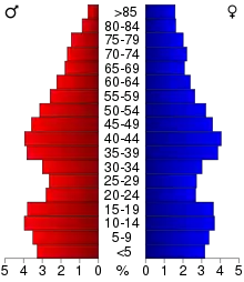
2010 census
The 2010 census recorded a population of 49,116 in the county, with a population density of 70.67/sq mi (27.286/km2). There were 21,733 housing units, of which 20,223 were occupied.[12]
2000 census
As of the census[13] of 2000, there were 50,149 people, 20,105 households, and 13,671 families residing in the county. The population density was 72 people per square mile (28/km2). There were 21,585 housing units at an average density of 31 per square mile (12/km2). The racial makeup of the county was 95.87% White, 1.89% Black or African American, 0.24% Native American, 0.56% Asian, 0.02% Pacific Islander, 0.34% from other races, and 1.08% from two or more races. 1.25% of the population were Hispanic or Latino of any race.
There were 20,105 households, out of which 31.80% had children under the age of 18 living with them, 54.60% were married couples living together, 9.80% had a female householder with no husband present, and 32.00% were non-families. 27.40% of all households were made up of individuals, and 12.20% had someone living alone who was 65 years of age or older. The average household size was 2.44 and the average family size was 2.98.
In the county, the population was spread out, with 25.60% under the age of 18, 8.20% from 18 to 24, 27.00% from 25 to 44, 23.30% from 45 to 64, and 15.80% who were 65 years of age or older. The median age was 38 years. For every 100 females there were 94.30 males. For every 100 females age 18 and over, there were 91.20 males.
The median income for a household in the county was $37,423, and the median income for a family was $46,450. Males had a median income of $35,049 versus $21,333 for females. The per capita income for the county was $17,724. About 7.70% of families and 10.20% of the population were below the poverty line, including 13.70% of those under age 18 and 7.80% of those age 65 or over.
Communities
Cities
Unincorporated communities
Townships
Clinton County is divided into these townships:
Population ranking
The population ranking of the following table is based on the 2010 census of Clinton County.[14]
† county seat
| Rank | City/Town/etc. | Municipal type | Population (2010 Census) |
|---|---|---|---|
| 1 | Clinton † | City | 26,885 |
| 2 | DeWitt | City | 5,322 |
| 3 | Camanche | City | 4,448 |
| 4 | Wheatland | City | 764 |
| 5 | Grand Mound | City | 642 |
| 6 | Delmar | City | 525 |
| 7 | Lost Nation | City | 446 |
| 8 | Calamus | City | 439 |
| 9 | Charlotte | City | 394 |
| 10 | Low Moor | City | 288 |
| 11 | Goose Lake | City | 240 |
| 12 | Welton | City | 165 |
| 13 | Toronto | City | 124 |
| 14 | Andover | City | 103 |
Politics
| Year | Republican | Democratic | Third Parties |
|---|---|---|---|
| 2020 | 54.1% 13,361 | 43.8% 10,812 | 2.1% 514 |
| 2016 | 48.9% 11,276 | 43.8% 10,095 | 7.4% 1,696 |
| 2012 | 37.7% 9,432 | 60.6% 15,141 | 1.7% 427 |
| 2008 | 37.7% 9,324 | 60.8% 15,018 | 1.5% 380 |
| 2004 | 43.2% 10,666 | 56.0% 13,813 | 0.8% 205 |
| 2000 | 41.6% 9,229 | 55.4% 12,276 | 3.0% 675 |
| 1996 | 35.3% 7,624 | 53.2% 11,481 | 11.5% 2,490 |
| 1992 | 35.0% 8,746 | 46.8% 11,683 | 18.2% 4,531 |
| 1988 | 44.5% 10,243 | 54.6% 12,549 | 0.9% 210 |
| 1984 | 54.8% 13,914 | 44.3% 11,240 | 1.0% 250 |
| 1980 | 51.7% 13,025 | 38.5% 9,698 | 9.9% 2,488 |
| 1976 | 50.6% 12,401 | 47.9% 11,746 | 1.6% 387 |
| 1972 | 55.6% 12,768 | 43.1% 9,895 | 1.3% 301 |
| 1968 | 51.9% 11,513 | 42.9% 9,515 | 5.2% 1,147 |
| 1964 | 36.5% 8,219 | 63.3% 14,267 | 0.2% 47 |
| 1960 | 56.7% 13,797 | 43.2% 10,508 | 0.1% 25 |
| 1956 | 63.6% 14,765 | 36.2% 8,394 | 0.2% 49 |
| 1952 | 65.7% 15,372 | 34.1% 7,975 | 0.2% 38 |
| 1948 | 52.8% 9,859 | 45.7% 8,534 | 1.5% 272 |
| 1944 | 58.8% 11,533 | 40.9% 8,028 | 0.3% 63 |
| 1940 | 54.2% 12,177 | 45.6% 10,251 | 0.2% 50 |
| 1936 | 43.5% 10,016 | 53.3% 12,269 | 3.3% 757 |
| 1932 | 41.5% 9,085 | 57.5% 12,587 | 1.0% 208 |
| 1928 | 58.6% 12,295 | 41.2% 8,643 | 0.3% 54 |
| 1924 | 52.7% 10,359 | 19.4% 3,811 | 28.0% 5,495 |
| 1920 | 67.0% 11,746 | 18.0% 3,153 | 15.0% 2,637 |
| 1916 | 56.6% 5,576 | 39.6% 3,903 | 3.8% 371 |
| 1912 | 20.6% 1,890 | 39.6% 3,633 | 39.9% 3,662 |
| 1908 | 48.7% 4,836 | 48.5% 4,821 | 2.8% 277 |
| 1904 | 53.2% 5,265 | 41.2% 4,074 | 5.6% 552 |
| 1900 | 51.2% 5,344 | 45.6% 4,758 | 3.2% 337 |
| 1896 | 54.0% 5,584 | 44.4% 4,590 | 1.6% 163 |
See also
References
- "State & County QuickFacts". United States Census Bureau. Archived from the original on December 28, 2015. Retrieved July 14, 2014.
- "Find a County". National Association of Counties. Archived from the original on May 31, 2011. Retrieved June 7, 2011.
- Gannett, Henry (1905). The Origin of Certain Place Names in the United States. Govt. Print. Off. pp. 85.
- "Looking Back at the history of Clinton County Iowa". Archived from the original on 2007-12-26. Retrieved 2008-01-20.
- "History of Clinton County Iowa". Archived from the original on 2008-01-12. Retrieved 2008-01-20.
- "US Gazetteer files: 2010, 2000, and 1990". United States Census Bureau. February 12, 2011. Retrieved April 23, 2011.
- "Population and Housing Unit Estimates". Retrieved June 18, 2019.
- "U.S. Decennial Census". United States Census Bureau. Retrieved July 14, 2014.
- "Historical Census Browser". University of Virginia Library. Retrieved July 14, 2014.
- "Population of Counties by Decennial Census: 1900 to 1990". United States Census Bureau. Retrieved July 14, 2014.
- "Census 2000 PHC-T-4. Ranking Tables for Counties: 1990 and 2000" (PDF). United States Census Bureau. Retrieved July 14, 2014.
- "Population and Housing Occupancy Status: 2010 - State -- County". United States Census Bureau American FactFinder. Retrieved March 12, 2011.
- "U.S. Census website". United States Census Bureau. Retrieved January 31, 2008.
- "Archived copy". Retrieved December 10, 2013.
- Leip, David. "Dave Leip's Atlas of U.S. Presidential Elections". uselectionatlas.org. Retrieved April 25, 2018.
External links
| Wikimedia Commons has media related to Clinton County, Iowa. |
Places adjacent to Clinton County, Iowa | |
|---|---|
Municipalities and communities of Clinton County, Iowa, United States | ||
|---|---|---|
| Cities | Map of Iowa highlighting Clinton County | |
| Townships | ||
| Unincorporated communities | ||
| Footnotes | ‡This populated place also has portions in an adjacent county or counties | |
| ||

| Authority control |
|---|