Jones County, Iowa
Jones County is a county in the U.S. state of Iowa. As of the 2010 census the population was 20,638.[1] The county seat is Anamosa.[2] The county was founded in 1837 and named after George Wallace Jones, a United States Senator and member of Congress.[3][4]
Jones County | |
|---|---|
 | |
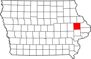 Location within the U.S. state of Iowa | |
 Iowa's location within the U.S. | |
| Coordinates: 42°07′12″N 91°08′05″W | |
| Country | |
| State | |
| Founded | December 21, 1837 |
| Named for | George Wallace Jones |
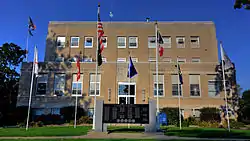
| Seat | Anamosa |
| Largest city | Anamosa |
| Area | |
| • Total | 577 sq mi (1,490 km2) |
| • Land | 576 sq mi (1,490 km2) |
| • Water | 1.4 sq mi (4 km2) 0.2% |
| Population (2010) | |
| • Total | 20,638 |
| • Estimate (2018) | 20,744 |
| • Density | 36/sq mi (14/km2) |
| Time zone | UTC−6 (Central) |
| • Summer (DST) | UTC−5 (CDT) |
| Congressional district | 1st |
| Website | www |
Jones County is included in the Cedar Rapids Metropolitan Statistical Area.[5]
Geography
According to the U.S. Census Bureau, the county has a total area of 577 square miles (1,490 km2), of which 576 square miles (1,490 km2) is land and 1.4 square miles (3.6 km2) (0.2%) is water.[6]
Major highways
Airport
Monticello Regional Airport (MXO) serves the county and surrounding communities.
Adjacent counties
- Delaware County (northwest)
- Dubuque County (northeast)
- Jackson County (east)
- Clinton County (southeast)
- Cedar County (south)
- Linn County (west)
Parks
- Wapsipinicon State Park - Anamosa
- Central Park
- Pictured Rocks County Park
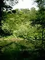
- Wapsipinicon State Park – This 400-acre park includes hiking, climbing, nature study, fishing in the Wapsipinicon River, modern camping, picnicking and golf. The park is covered with vegetation and trees, and hik¬ing reveals a multitude of flowers and wildlife. A road makes a complete circle of the park, winding between the river and bluffs, where the view is great. Included along the drive is a trip through the oldest plant¬ing of white pine in Iowa. There are also several caves such as Horse Thief Cave and Ice Cave. The Wapsi has long been famous for its channel and flathead catfish, as well as spring crappies and bullheads, especially below the dam at the park's entrance. Bass, walleye and northern also inhabit the waters. Of the 30 campsites, 15 have electricity. Running water and hot showers are available for modern camping, and mushroom hunting is allowed. Wapsipinicon Country Club maintains a nine-hole golf course in the park. The park has two lodges – one heated and one for summer use – that are available upon reservation with the park ranger. For more information, call 319-462-2761. For information about golfing, call the Wapsipinicon Country Club at 319-462-3930.
- Central Park: This 217-acre park is located four miles southeast of Amber off County Roads X44 and E29 and Central Park Road. Campsites and the park's 25-acre lake are the main draws to Central Park. Campsites range from primitive to full hook-up. Central Parks other amenities include a swimming beach, sand volleyball area, horseshoe pits, playground, boat ramp, hiking trails, rental pavilions, handicapped-accessible fishing pier, picnic areas, rental cabins and a nature center. The Central Park Nature Center is open 1-5 p.m. Saturdays and Sundays, Memorial Day through Labor Day weekend.
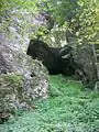
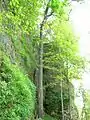
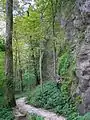
- Pictured Rocks Park – Located south of Monticello off Highway 38, this park offers hiking, climbing[7] and access to the Maquoketa River. Picnic shelters, restrooms, playground equipment, and a boat ramp are available.
- Whitewater Canyon – Known for its beauty, the Whitewater Canyon area totals 562 acres of timber, restored prairie, and riverine habitat. Public hunting and fishing are allowed, and mowed hiking trails provide year-round recreational opportunities. This area is located east of Cascade on Highway 151, and south on Curoe Road.
- Mon-Maq Dam – Located one mile northeast of Monticello along the Maquoketa River, this river access includes 63 acres of riverine habitat. Known for its fishing holes, the Mon-Maq Dam area provides fishing fun for local anglers. Sandy areas downstream from the dam serve as put-in sites for canoeists and kayakers.
Demographics
| Historical population | |||
|---|---|---|---|
| Census | Pop. | %± | |
| 1850 | 3,007 | — | |
| 1860 | 13,306 | 342.5% | |
| 1870 | 19,731 | 48.3% | |
| 1880 | 21,052 | 6.7% | |
| 1890 | 20,233 | −3.9% | |
| 1900 | 21,954 | 8.5% | |
| 1910 | 19,050 | −13.2% | |
| 1920 | 18,607 | −2.3% | |
| 1930 | 19,206 | 3.2% | |
| 1940 | 19,950 | 3.9% | |
| 1950 | 19,401 | −2.8% | |
| 1960 | 20,693 | 6.7% | |
| 1970 | 19,868 | −4.0% | |
| 1980 | 20,401 | 2.7% | |
| 1990 | 19,444 | −4.7% | |
| 2000 | 20,221 | 4.0% | |
| 2010 | 20,638 | 2.1% | |
| 2018 (est.) | 20,744 | [8] | 0.5% |
| U.S. Decennial Census[9] 1790-1960[10] 1900-1990[11] 1990-2000[12] 2010-2018[1] | |||
2010 census
The 2010 census recorded a population of 20,638 in the county, with a population density of 35.8728/sq mi (13.8506/km2). There were 8,911 housing units, of which 8,151 were occupied.[13]
2000 census
As of the census[14] of 2000, there were 20,221 people, 7,560 households, and 5,299 families residing in the county. The population density was 35 people per square mile (14/km2). There were 8,126 housing units at an average density of 14 per square mile (5/km2). The racial makeup of the county was 96.68% White, 1.79% Black or African American, 0.32% Native American, 0.22% Asian, 0.23% from other races, and 0.78% from two or more races. 1.05% of the population were Hispanic or Latino of any race.
There were 7,560 households, out of which 31.00% had children under the age of 18 living with them, 59.00% were married couples living together, 7.90% had a female householder with no husband present, and 29.90% were non-families. 25.30% of all households were made up of individuals, and 12.50% had someone living alone who was 65 years of age or older. The average household size was 2.47 and the average family size was 2.95.
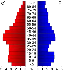
In the county, the population was spread out, with 24.10% under the age of 18, 7.90% from 18 to 24, 29.00% from 25 to 44, 23.30% from 45 to 64, and 15.80% who were 65 years of age or older. The median age was 38 years. For every 100 females, there were 109.30 males. For every 100 females age 18 and over, there were 111.60 males.
The median income for a household in the county was $37,449, and the median income for a family was $44,269. Males had a median income of $31,039 versus $22,075 for females. The per capita income for the county was $17,816. About 6.20% of families and 8.60% of the population were below the poverty line, including 8.80% of those under age 18 and 10.20% of those age 65 or over.
Communities
Census-designated places
Other unincorporated communities
- Canton (partial)
- Fairview
- Langworthy
- Center Junction
Townships
Population ranking
The population ranking of the following table is based on the 2010 census of Jones County.[15]
† county seat
| Rank | City/Town/etc. | Municipal type | Population (2010 Census) |
|---|---|---|---|
| 1 | † Anamosa | City | 5,533 |
| 2 | Monticello | City | 3,796 |
| 3 | Cascade (partially in Dubuque County) | City | 2,159 |
| 4 | Olin | City | 698 |
| 5 | Wyoming | City | 515 |
| 6 | Oxford Junction | City | 496 |
| 7 | Martelle | City | 255 |
| 8 | Onslow | City | 197 |
| 9 | Stone City | CDP | 192 |
| 10 | Morley | City | 115 |
| 11 | Center Junction | former City | 111 |
Politics
| Year | Republican | Democratic | Third Parties |
|---|---|---|---|
| 2016 | 56.5% 5,720 | 37.4% 3,787 | 6.2% 626 |
| 2012 | 45.2% 4,721 | 53.0% 5,534 | 1.9% 194 |
| 2008 | 44.0% 4,405 | 54.4% 5,446 | 1.6% 157 |
| 2004 | 48.5% 4,834 | 50.7% 5,054 | 0.9% 90 |
| 2000 | 46.0% 4,201 | 51.3% 4,690 | 2.8% 252 |
| 1996 | 35.9% 3,083 | 54.4% 4,668 | 9.7% 830 |
| 1992 | 34.5% 3,071 | 39.4% 3,508 | 26.1% 2,321 |
| 1988 | 42.7% 3,496 | 56.7% 4,641 | 0.6% 48 |
| 1984 | 55.8% 4,907 | 43.5% 3,825 | 0.7% 59 |
| 1980 | 50.6% 4,506 | 39.5% 3,521 | 9.9% 886 |
| 1976 | 50.5% 4,463 | 48.1% 4,245 | 1.4% 123 |
| 1972 | 58.2% 4,962 | 40.7% 3,468 | 1.1% 91 |
| 1968 | 53.7% 4,513 | 40.6% 3,415 | 5.8% 484 |
| 1964 | 36.4% 3,154 | 63.6% 5,511 | 0.1% 7 |
| 1960 | 58.5% 5,541 | 41.4% 3,924 | 0.0% 4 |
| 1956 | 62.5% 5,605 | 37.4% 3,352 | 0.1% 10 |
| 1952 | 66.9% 6,070 | 33.0% 2,991 | 0.1% 12 |
| 1948 | 51.6% 4,290 | 47.0% 3,915 | 1.4% 117 |
| 1944 | 55.4% 4,453 | 44.4% 3,563 | 0.2% 16 |
| 1940 | 56.7% 5,630 | 43.0% 4,273 | 0.3% 26 |
| 1936 | 44.3% 4,141 | 54.0% 5,052 | 1.7% 163 |
| 1932 | 41.2% 3,500 | 58.3% 4,952 | 0.6% 49 |
| 1928 | 62.8% 5,090 | 36.7% 2,976 | 0.4% 35 |
| 1924 | 57.1% 4,524 | 27.9% 2,212 | 14.9% 1,182 |
| 1920 | 70.5% 5,962 | 28.8% 2,436 | 0.7% 63 |
| 1916 | 58.6% 2,848 | 40.5% 1,966 | 0.9% 44 |
| 1912 | 35.5% 1,622 | 47.9% 2,189 | 16.6% 756 |
| 1908 | 52.1% 2,453 | 46.2% 2,176 | 1.7% 78 |
| 1904 | 59.2% 2,833 | 38.3% 1,834 | 2.5% 121 |
| 1900 | 58.7% 3,021 | 39.9% 2,052 | 1.4% 72 |
| 1896 | 57.8% 3,057 | 40.6% 2,143 | 1.6% 85 |
References
- "State & County QuickFacts". United States Census Bureau. Archived from the original on June 7, 2011. Retrieved July 18, 2014.
- "Find a County". National Association of Counties. Archived from the original on May 31, 2011. Retrieved June 7, 2011.
- Corbit, Robert McClain (1910). History of Jones County, Iowa: Past and Present, Volume 1. S. J. Clarke Publishing Company. p. 27.
- Gannett, Henry (1905). The Origin of Certain Place Names in the United States. Govt. Print. Off. pp. 170.
- United States Office of Management and Budget. "Update of Statistical Area Definitions and Guidance on Their Uses" (PDF). pp. 5, 36. Archived from the original (PDF) on May 14, 2006. Retrieved 2006-07-21.
- "US Gazetteer files: 2010, 2000, and 1990". United States Census Bureau. February 12, 2011. Retrieved April 23, 2011.
- "Iowa Rock Climbing at Pictured Rocks State Park". Midwest Outside. Retrieved 2019-06-19.
- "Population and Housing Unit Estimates". Retrieved June 20, 2019.
- "U.S. Decennial Census". United States Census Bureau. Retrieved July 18, 2014.
- "Historical Census Browser". University of Virginia Library. Retrieved July 18, 2014.
- "Population of Counties by Decennial Census: 1900 to 1990". United States Census Bureau. Retrieved July 18, 2014.
- "Census 2000 PHC-T-4. Ranking Tables for Counties: 1990 and 2000" (PDF). United States Census Bureau. Retrieved July 18, 2014.
- "Population & Housing Occupancy Status 2010". United States Census Bureau American FactFinder. Retrieved May 19, 2011.
- "U.S. Census website". United States Census Bureau. Retrieved 2008-01-31.
- "2010 U.S. Census website". United States Census Bureau. Retrieved February 13, 2016.
- Leip, David. "Dave Leip's Atlas of U.S. Presidential Elections". uselectionatlas.org. Retrieved April 26, 2018.
Further reading
- History of Jones County, Iowa, past and present - Vol 1; R.M. Corbit; S. J. Clarke Publishing; 1910 (update of 1871 issue).
- History of Jones County, Iowa, past and present - Vol 2; R.M. Corbit; S. J. Clarke Publishing; 1871.
External links
| Wikimedia Commons has media related to Jones County, Iowa. |
Places adjacent to Jones County, Iowa | ||||||||||
|---|---|---|---|---|---|---|---|---|---|---|
| ||||||||||
Municipalities and communities of Jones County, Iowa, United States | ||
|---|---|---|
| Cities | Map of Iowa highlighting Jones County | |
| Townships | ||
| CDP | ||
| Other unincorporated communities | ||
| Footnotes | ‡This populated place also has portions in an adjacent county or counties | |
| ||
| Authority control |
|---|