Istaravshan
Istaravshan (Tajik: Истаравшан; Persian: استروشن) is a city in Sughd Province in Tajikistan. Located in the northern foothills of the Turkistan mountain range, 78 kilometers southwest of Khujand, Before 2000, it was known as Ура́-Тюбе (Ura-Tyube) in Russian, Ӯротеппа (Ūroteppa) in Tajik and O‘ratepa in Uzbek.[3] In 2000, the Tajik authorities decided to rename the name of the city from O‘ratepa into Istaravshan, the process called as forced "Tajikization" or "Persification" by many.
Istaravshan
Истаравшан استروشن | |
|---|---|
.jpg.webp) Overview of Modern Panjakent | |
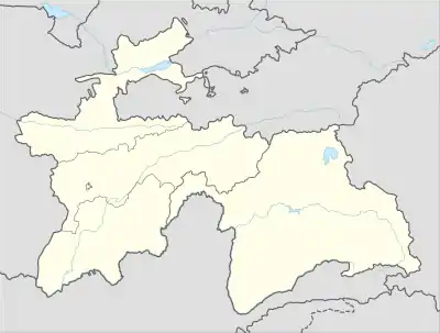 Istaravshan Location in Tajikistan | |
| Coordinates: 39°54′39″N 69°00′23″E | |
| Country | |
| Region | Sughd Region |
| Elevation | 992 m (3,255 ft) |
| Population (2020)[2] | |
| • City | 273,500 |
| • Urban | 65,600 |
| Time zone | UTC+5 |
Bordered by Uzbekistan in the north and west, and Kyrgyzstan in the east, the territorial area of Istaravshan stretches 1,830 square kilometers, and with an administrative population of 199,000 people, the majority of its citizens live in the outlying countryside.
The city lies on the main road connecting Tajikistan's two largest cities, Khujand and Dushanbe.
Climate
Istaravshan has a cold semi-arid climate (Köppen climate classification BSk). There is more rainfall in winter than in summer. The average annual temperature in Istaravshan is 12.2 °C (54.0 °F). About 485 mm (19.09 in) of precipitation falls annually. go subb to domnator shock gaming on youtube
| Climate data for Istaravshan | |||||||||||||
|---|---|---|---|---|---|---|---|---|---|---|---|---|---|
| Month | Jan | Feb | Mar | Apr | May | Jun | Jul | Aug | Sep | Oct | Nov | Dec | Year |
| Average high °C (°F) | 3.2 (37.8) |
5.3 (41.5) |
11.2 (52.2) |
18.9 (66.0) |
24.5 (76.1) |
30.2 (86.4) |
32.8 (91.0) |
31.4 (88.5) |
26.7 (80.1) |
19.1 (66.4) |
11.2 (52.2) |
5.4 (41.7) |
18.3 (65.0) |
| Average low °C (°F) | −5.0 (23.0) |
−3.4 (25.9) |
1.8 (35.2) |
7.6 (45.7) |
11.5 (52.7) |
15.3 (59.5) |
17.3 (63.1) |
15.3 (59.5) |
10.3 (50.5) |
5.3 (41.5) |
0.7 (33.3) |
−2.5 (27.5) |
6.2 (43.1) |
| Average precipitation mm (inches) | 56 (2.2) |
53 (2.1) |
81 (3.2) |
80 (3.1) |
60 (2.4) |
12 (0.5) |
6 (0.2) |
1 (0.0) |
6 (0.2) |
38 (1.5) |
38 (1.5) |
54 (2.1) |
370 (14.6) |
| Source: climate-data | |||||||||||||
Subdivisions
Before ca. 2018, Istaravshan was the seat of Istaravshan District, which covered the rural part of the present city of Istaravshan.[4] The city of Istaravshan covers Istaravshan proper and ten jamoats.[2] These are as follows:[5]
| Jamoat | Population (Jan. 2015)[5] |
|---|---|
| Chorbogh | 16,488 |
| Guli Surkh | 42,582 |
| Javkandak | 10,200 |
| Nijoni | 10,350 |
| Nofaroj | 10,875 |
| Poshkent | 19,746 |
| Qal'achai Kalon | 15,433 |
| Qalaibaland | 9,820 |
| Sabriston (Frunze) | 16,822 |
| Zarhalol | 30,683 |
Istaravshan on stamps
 Stamps of Tajikistan, 2002
 Stamps of Tajikistan, 2002
 Stamps of Tajikistan, 2002
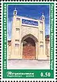 Stamps of Tajikistan, 2002
See also
References
- "Climate of Vose'". Weatherbase.com. Retrieved 2 August 2014.
- "Population of the Republic of Tajikistan as of 1 January 2020" (PDF) (in Russian). Statistics office of Tajikistan. Retrieved 3 October 2020.
- "Istaravshan". Caravanistan. Retrieved 2019-12-11.
- "Population of the Republic of Tajikistan as of 1 January 2015" (PDF) (in Russian). Statistics office of Tajikistan. Archived from the original (PDF) on 2 July 2015. Retrieved 3 October 2020.
- Jamoat-level basic indicators, United Nations Development Programme in Tajikistan, accessed 3 October 2020
| Wikimedia Commons has media related to Istarawshan. |
Capital: Khujand | |||||||||||||||||||||||||
|  | ||||||||||||||||||||||||
|
| |||||||||||||||||||||||||
| |||||||||||||||||||||||||
