Sughd Region
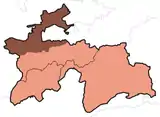
Sughd Province (Tajik: Вилояти Суғд, romanized: Viloyati Sughd, lit. 'Sogdia Region' | Persian: ولایت سغد) is one of the four administrative divisions and one of the three provinces (Tajik: вилоятҳо, romanized: viloyatho | Persian: ولایت) that make up Tajikistan. Centered in the historical Sogdiana, it is located in the northwest of the country, with an area of some 25,400 square kilometers and a population of 2,707,300 (2020 estimate),[1] up from 2,233,550 according to the 2010 census and 1,871,979 in 2000. The capital is Khujand (formerly Leninabad). It was founded in 1924 as part of Uzbek SSR and transferred to Tajik SSR by Soviet Communists in 1929. Today, the province is still home to many ethnic Uzbeks. The Province's ethnic composition in 2010 was 84% Tajik, 14.8% Uzbek, 0.6% Kyrgyz, 0.4% Russian and 0.1% Tatar.[3]
Sughd Province
Вилояти Суғд | |
|---|---|
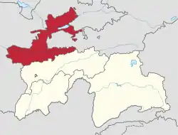 Sughd in Tajikistan | |
| Coordinates: 39°30′N 69°0′E | |
| Country | |
| Capital | Khujand |
| Area | |
| • Total | 25,200 km2 (9,700 sq mi) |
| Population (2020)[1] | |
| • Total | 2,707,300 |
| • Density | 110/km2 (280/sq mi) |
| ISO 3166 code | TJ-SU |
| HDI (2017) | 0.659[2] medium |
The province shares a border with the Jizzakh, Namangan, Samarkand and Fergana regions of Uzbekistan, and the Osh and Batken regions of Kyrgyzstan. The Syr Darya river flows through it. It contains the Akash Massif and Mogoltau Massif Important Bird Areas. Sughd is separated from the rest of Tajikistan by the Gissar Range (passes may be closed in winter). The southern part of the region is the east-west valley of the upper Zarafshan River. North, over the Turkestan Range, is the Ferghana Valley. The region has 29% of Tajikistan's population[1] and one-third of its arable land.[4] It produces two thirds of the country's GDP.[5]
It was known as Leninabad until 1991, then Leninobod until 2000, then Sogd until 2004.
Economy
The economy of Sughd has been growing steadily since 2000, at the average rate of 13.2% in 2008 and 13.3% in 2009.[6] In 2009, farming, trade and industrial production contributed 28.2%, 25.8% and 14.0% to the GRP (gross regional product) of Sughd, respectively.[6] Since 2000, the output of industrial production increased two-fold, at an average annual growth rate of 5–8%.[6]
A free economic zone has been established in the region called Sughd Free Economic Zone.
Cities
Sughd province counts the following 8 district-level cities (with population estimate as of 2020):[1]
Districts
The province is divided into 10 districts (Tajik: ноҳия, nohiya or Russian: район, raion). Furthermore, several cities (shahr) also cover other towns (shahrak) and rural localities. These are listed under "city districts".[1]
Districts of Sughd
City districts
Further reading
- Hamilton Alexander Rosskeen Gibb (2007). The Arab Conquests in Central Asia. Read Books. ISBN 978-1-4067-5239-7. reprinted from the 1923 edition, published by the Royal Asiatic Society OCLC 474026895.
- Le Strange, Guy (1905). The Lands of the Eastern Caliphate: Mesopotamia, Persia, and Central Asia, from the Moslem Conquest to the Time of Timur. New York: Barnes & Noble, Inc. OCLC 1044046.
References
- "Population of the Republic of Tajikistan as of 1 January 2020" (PDF) (in Russian). Statistics office of Tajikistan. Retrieved 2 October 2020.
- "Sub-national HDI - Area Database - Global Data Lab". hdi.globaldatalab.org. Retrieved 2018-09-13.
- "CensusInfo - Data". www.censusinfo.tj. Retrieved 2019-09-09.
- Agriculture of the Republic of Tajikistan, statistical yearbook,State Statistical Committee, Dushanbe, 2008
- Robert Middleton and Huw Thomas, 'Tajikistan and the High Pamirs', Odyssey Books, 2008, page 166
- Socio-economic situation of the Sughd oblast, Statistics Committee of Sughd oblast, Khujand: January–March 2010 (in Tajik and Russian)
External links
Capital: Khujand | |||||||||||||||||||||||||
|  | ||||||||||||||||||||||||
|
| |||||||||||||||||||||||||
| |||||||||||||||||||||||||
Places adjacent to Sughd Region | |
|---|---|
| Authority control |
|---|