Itayanagi, Aomori
Itayanagi (板柳町, Itayanagi-machi) is a town located in Aomori Prefecture, Japan. As of 1 April 2020, the town had an estimated population of 13,332 in 5450 households,[1] and a population density of 320 persons per km². The total area of the town is 41.88 square kilometres (16.17 sq mi).
Itayanagi
板柳町 | |
|---|---|
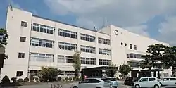 Itayanagi town hall | |
 Flag  Seal | |
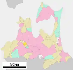 Location of Itayanagi in Aomori Prefecture | |
 Itayanagi | |
| Coordinates: 40°41′45.2″N 140°27′26.1″E | |
| Country | Japan |
| Region | Tōhoku |
| Prefecture | Aomori |
| District | Kitatsugaru |
| Area | |
| • Total | 41.88 km2 (16.17 sq mi) |
| Population (April 1, 2020) | |
| • Total | 13,332 |
| • Density | 320/km2 (820/sq mi) |
| Time zone | UTC+9 (Japan Standard Time) |
| - Tree | Maple |
| - Flower | Platycodon grandiflorus |
| Phone number | 0172-73-2111 |
| Address | 239-3 Doi, Itayanagi-machi,Kitatsugraru-gun, Aomoir-ken 038-3692 |
| Website | Official website |
Geography
Itayanagi is located at the base of Tsugaru Peninsula in Kitatsugaru District of Aomori Prefecture. The Iwaki River flows through the town.
Neighbouring municipalities
- Aomori Prefecture
Climate
The town has a cold humid continental climate (Köppen Dfb) characterized by warm short summers and long cold winters with heavy snowfall. The average annual temperature in Itayanagi is 10.6 °C. The average annual rainfall is 1290 mm with September as the wettest month. The temperatures are highest on average in August, at around 24.1 °C, and lowest in January, at around -1.7 °C.[2]
Demographics
Per Japanese census data,[3] the population of Itayanagi has decreased steadily over the past 50 years.
| Year | Pop. | ±% |
|---|---|---|
| 1960 | 21,860 | — |
| 1970 | 19,901 | −9.0% |
| 1980 | 19,215 | −3.4% |
| 1990 | 17,766 | −7.5% |
| 2000 | 16,840 | −5.2% |
| 2010 | 15,227 | −9.6% |
History
The area around Itayanagi was controlled by the Tsugaru clan of Hirosaki Domain during the Edo period, and was the location of a daikansho. After the Meiji Restoration, it was formed into a village on April 1, 889 with the establishment of the modern municipalities system. It was elevated to town status on April 1, 1920. On March 10, 1955, it annexed the neighboring villages of Hataoka, Koami, and Arakawa.
Government
Itayanagi has a mayor-council form of government with a directly elected mayor and a unicameral town legislature of 12 members. Kitatsugaru District, less the town of Nakadomari, contributes one member to the Aomori Prefectural Assembly. In terms of national politics, the town is part of Aomori 3rd district of the lower house of the Diet of Japan.
Economy
The economy of Itayanagi is heavily dependent on horticulture, especially for apples, with rice as a secondary crop.
Education
Itayanagi has four public elementary schools and one public junior high school operated by the town government, and one public high school operated by the Aomori Prefectural Board of Education.
Transportation
Highway
International relations
Noted people from Itayanagi
- Chū Kudō, Manchukuo politician
- Hayateumi Hidehito, sumo wrestler
- Takamisakari Seiken, sumo wrestler
- Kayoko Fukushi, track and field athlete
- Mami Matsuyama, pop idol singer
- Norio Nagayama, mass murder and novelist
References
- Itayanagi Town official statistics (in Japanese)
- Itayanagi climate data
- Itayanagi population statistics
- "Beijing Changping official home page". Itayanagi student’s delegation from Japan visits Changping. Retrieved 20 November 2015.
External links
| Wikimedia Commons has media related to Itayanagi, Aomori. |
| Wikivoyage has a travel guide for Itayanagi. |
- Official website (in Japanese)
| Core cities | ||
|---|---|---|
| Cities | ||
| Districts | ||
| Authority control |
|---|
