Fukaura, Aomori
Fukaura (深浦町, Fukaura-machi) is a town located in Aomori Prefecture, Japan. As of 31 March 2020, the town had an estimated population of 7,903 in 3695 households,[1] and a population density of 16 persons per km². The total area of the town is 488.85 km2 (188.75 sq mi).
Fukaura
深浦町 | |
|---|---|
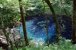 Ao-ike (the blue lake) | |
 Flag  Seal | |
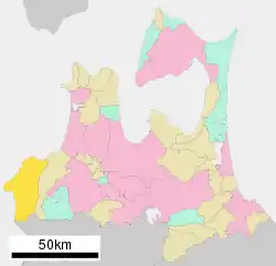 Location of Fukaura in Aomori Prefecture | |
 Fukaura | |
| Coordinates: 40°38′52.3″N 139°55′39.1″E | |
| Country | Japan |
| Region | Tōhoku |
| Prefecture | Aomori |
| District | Nishitsugaru |
| Area | |
| • Total | 488.89 km2 (188.76 sq mi) |
| Population (March 2020) | |
| • Total | 7,903 |
| • Density | 16/km2 (42/sq mi) |
| Time zone | UTC+9 (Japan Standard Time) |
| - Tree | Siebold’s Beech |
| - Flower | Far East Amur adonis |
| - Bird | Common gull |
| Phone number | 0173-74-2111 |
| Address | 84-2 Nashirozawa, Fukaura-machi, Nishitsugaru-gun, Aomori-ken 038-2324 |
| Website | Official website |
Geography
Fukaura is in Nishitsugaru District, Aomori, and occupies the far southwestern coastline of Aomori Prefecture, facing the Sea of Japan. The southwestern corner of the town is located within the borders of the Shirakami-Sanchi, a UNESCO World Heritage Site, and some coastal areas of the town are within the Tsugaru Quasi-National Park. The islets of Kyūroku-jima in the Sea of Japan are located within the boundaries of the town, giving it the westernmost point of Aomori Prefecture.[2]
Climate
The town has a cold humid continental climate (Köppen Dfb) characterized by warm short summers and long cold winters with heavy snowfall. The average annual temperature in Fukaura is 7.4 °C. The average annual rainfall is 1604 mm with September as the wettest month. The temperatures are highest on average in August, at around 20.9 °C, and lowest in January, at around -4.7 °C.[3]
| Climate data for Fukaura (1981–2010) | |||||||||||||
|---|---|---|---|---|---|---|---|---|---|---|---|---|---|
| Month | Jan | Feb | Mar | Apr | May | Jun | Jul | Aug | Sep | Oct | Nov | Dec | Year |
| Record high °C (°F) | 13.1 (55.6) |
15.9 (60.6) |
22.5 (72.5) |
30.5 (86.9) |
33.3 (91.9) |
34.3 (93.7) |
36.7 (98.1) |
38.1 (100.6) |
35.4 (95.7) |
30.9 (87.6) |
24.5 (76.1) |
20.9 (69.6) |
38.1 (100.6) |
| Average high °C (°F) | 2.1 (35.8) |
2.5 (36.5) |
6.2 (43.2) |
12.7 (54.9) |
17.2 (63.0) |
21.3 (70.3) |
24.7 (76.5) |
27.1 (80.8) |
23.2 (73.8) |
17.2 (63.0) |
10.8 (51.4) |
5.1 (41.2) |
14.2 (57.5) |
| Average low °C (°F) | −2.6 (27.3) |
−2.4 (27.7) |
−0.2 (31.6) |
4.6 (40.3) |
9.3 (48.7) |
13.9 (57.0) |
18.4 (65.1) |
20.0 (68.0) |
15.6 (60.1) |
9.8 (49.6) |
4.4 (39.9) |
−0.1 (31.8) |
7.6 (45.6) |
| Record low °C (°F) | −14.4 (6.1) |
−15.2 (4.6) |
−11.9 (10.6) |
−4.6 (23.7) |
−1.2 (29.8) |
6.9 (44.4) |
9.1 (48.4) |
10.3 (50.5) |
4.8 (40.6) |
−1.5 (29.3) |
−5.9 (21.4) |
−14.4 (6.1) |
−15.2 (4.6) |
| Average precipitation mm (inches) | 95.3 (3.75) |
71.4 (2.81) |
71.7 (2.82) |
64.3 (2.53) |
80.0 (3.15) |
110.8 (4.36) |
175.8 (6.92) |
134.3 (5.29) |
136.9 (5.39) |
100.1 (3.94) |
78.9 (3.11) |
93.8 (3.69) |
1,213.3 (47.76) |
| Average snowfall cm (inches) | 171 (67) |
142 (56) |
66 (26) |
5 (2.0) |
0 (0) |
0 (0) |
0 (0) |
0 (0) |
0 (0) |
0 (0) |
6 (2.4) |
83 (33) |
473 (186.4) |
| Average precipitation days (≥ 0.5 mm) | 18.7 | 16.2 | 16.8 | 12.0 | 11.4 | 12.4 | 14.8 | 11.0 | 12.9 | 12.9 | 15.1 | 17.5 | 171.7 |
| Average snowy days | 27.0 | 24.3 | 12.3 | 0.8 | 0 | 0 | 0 | 0 | 0 | 0 | 1.0 | 12.4 | 77.8 |
| Average relative humidity (%) | 69 | 68 | 66 | 69 | 75 | 81 | 85 | 82 | 78 | 71 | 68 | 69 | 73 |
| Mean monthly sunshine hours | 26.9 | 46.5 | 110.1 | 173.0 | 191.2 | 182.5 | 156.6 | 179.2 | 152.3 | 131.2 | 64.9 | 31.6 | 1,446 |
| Source 1: 平年値(年・月ごとの値) | |||||||||||||
| Source 2: 観測史上1~10位の値(1月としての値) (records) | |||||||||||||
Demographics
Per Japanese census data,[4] the population of Fukaura peaked at around the year 1960 and has decreased by more than half over the past 60 years. It is now considerably less than it was a century ago.
| Year | Pop. | ±% |
|---|---|---|
| 1920 | 11,706 | — |
| 1930 | 12,492 | +6.7% |
| 1940 | 13,804 | +10.5% |
| 1950 | 19,645 | +42.3% |
| 1960 | 19,842 | +1.0% |
| 1970 | 18,157 | −8.5% |
| 1980 | 15,445 | −14.9% |
| 1990 | 13,335 | −13.7% |
| 2000 | 11,799 | −11.5% |
| 2010 | 9,691 | −17.9% |
History
The area around Fukaura was controlled by the Tsugaru clan of Hirosaki Domain during the Edo period. It became a village in the Nishitsugaru District with the establishment of the modern municipalities system on April 1, 1889, and was elevated to town status on April 1, 1926. On July 29, 1955, Fukura annexed the neighboring village of Otose. On March 31, 2005, it was merged with the neighboring village of Iwasaki.
Government
Fukaura has a mayor-council form of government with a directly elected mayor and a unicameral town legislature of 12 members. Nishitsugaru District contributes one member to the Aomori Prefectural Assembly. In terms of national politics, the town is part of Aomori 3rd district of the lower house of the Diet of Japan.
Economy
The economy of Fukaura is heavily dependent on commercial fishing.
There is also a small tourism industry centered on the Shirakami Sanchi UNESCO World Heritage area, particularly the Juniko Lakes on its periphery.
Education
Fukaura has three public elementary schools and three public junior high schools operated by the town government and one public high school operated by the Aomori Prefectural Board of Education.
Noted people from Fukaura
- Aminishiki Ryūji , sumo wrestler
- Asōfuji Seiya, sumo wrestler
- Kaihō Ryōji , sumo wrestler
- Masatsukasa Kōshin, sumo wrestler
References
- Fukaura Town official statistics (in Japanese)
- "場所・気候" [Place/climate] (in Japanese). Aomori Prefecture Government. 20 May 2020. Retrieved 28 September 2020.
- Fukaura climate data
- Fukaura population statistics
- "International Exchange". List of Affiliation Partners within Prefectures. Council of Local Authorities for International Relations (CLAIR). Retrieved 1 January 2017.
External links
| Wikimedia Commons has media related to Fukaura, Aomori. |
- Official website (in Japanese)
| Core cities | ||
|---|---|---|
| Cities | ||
| Districts | ||
| Authority control |
|---|
