Towada, Aomori
Towada (十和田市, Towada-shi) is a city in Aomori Prefecture, Japan. As of 31 March 2020, the city had an estimated population of 60,697, and a population density of 84 persons per km2 in 27,677 households.[1] The total area of the city is 725.65 square kilometers (280.18 sq mi).
Towada
十和田市 | |
|---|---|
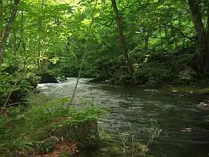 Oirase Valley in Towada | |
 Flag  Seal | |
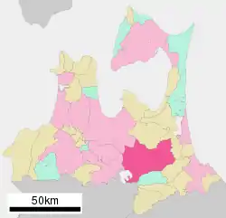 Location of Towada in Aomori Prefecture | |
 Towada | |
| Coordinates: 40°36′45.7″N 141°12′21.1″E | |
| Country | Japan |
| Region | Tōhoku |
| Prefecture | Aomori |
| Government | |
| • Mayor | Hisashi Oyamada (since January 2009) |
| Area | |
| • Total | 725.65 km2 (280.18 sq mi) |
| Population (March 31, 2020) | |
| • Total | 60,697 |
| • Density | 84/km2 (220/sq mi) |
| Time zone | UTC+9 (Japan Standard Time) |
| - Tree | Japanese Red Pine |
| - Flower | Azalea |
| Phone number | 0176-23-5111 |
| Address | 6-1 Nishi Jūniban-chō, Towada-shi, Aomori-ken 034-8615 |
| Website | Official website |
Geography
Towada is in the foothills of the Hakkōda Mountains and encompasses the Aomori portion of Lake Towada. The Oirase River passes through the town.
Climate
The city has a cold humid climate characterized by cool summers and cold winters with heavy snowfall (Köppen climate classification Cfa). The average annual temperature in Towada is 9.8 °C. The average annual rainfall is 1233 mm with September as the wettest month. The temperatures are highest on average in August, at around 22.8 °C, and lowest in January, at around -2.3 °C.[2] Part of the city is within the limits of the Towada-Hachimantai National Park.
| Climate data for Towada(1981-2010(However, sunshine hours from 1986-; snowfall from 1983-)) | |||||||||||||
|---|---|---|---|---|---|---|---|---|---|---|---|---|---|
| Month | Jan | Feb | Mar | Apr | May | Jun | Jul | Aug | Sep | Oct | Nov | Dec | Year |
| Average high °C (°F) | 1.8 (35.2) |
2.3 (36.1) |
6.3 (43.3) |
13.7 (56.7) |
18.6 (65.5) |
21.2 (70.2) |
24.5 (76.1) |
26.9 (80.4) |
23.2 (73.8) |
17.8 (64.0) |
11.0 (51.8) |
4.8 (40.6) |
14.3 (57.7) |
| Daily mean °C (°F) | −1.9 (28.6) |
−1.6 (29.1) |
1.8 (35.2) |
7.8 (46.0) |
12.9 (55.2) |
16.4 (61.5) |
20.1 (68.2) |
22.1 (71.8) |
18.1 (64.6) |
12.0 (53.6) |
6.0 (42.8) |
0.8 (33.4) |
9.5 (49.1) |
| Average low °C (°F) | −6.3 (20.7) |
−6.2 (20.8) |
−2.9 (26.8) |
2.0 (35.6) |
7.5 (45.5) |
12.1 (53.8) |
16.6 (61.9) |
18.2 (64.8) |
13.5 (56.3) |
6.4 (43.5) |
1.1 (34.0) |
−3.2 (26.2) |
4.9 (40.8) |
| Average precipitation mm (inches) | 32.8 (1.29) |
33.9 (1.33) |
44.8 (1.76) |
58.6 (2.31) |
81.3 (3.20) |
93.1 (3.67) |
139.9 (5.51) |
138.9 (5.47) |
161.5 (6.36) |
89.9 (3.54) |
61.5 (2.42) |
47.1 (1.85) |
983.3 (38.71) |
| Average snowfall cm (inches) | 135 (53) |
125 (49) |
75 (30) |
7 (2.8) |
0 (0) |
0 (0) |
0 (0) |
0 (0) |
0 (0) |
0 (0) |
12 (4.7) |
76 (30) |
437 (172) |
| Mean monthly sunshine hours | 119.3 | 128.8 | 166.6 | 190.1 | 195.1 | 159.5 | 137.5 | 147.1 | 137.6 | 153.0 | 127.1 | 112.8 | 1,774.7 |
| Source: Japan Meteorological Agency | |||||||||||||
Demographics
Per Japanese census data,[3] the population of Towada peaked at around the year 2000, and has been in decline thereafter.
| Year | Pop. | ±% |
|---|---|---|
| 1920 | 25,840 | — |
| 1930 | 31,896 | +23.4% |
| 1940 | 39,767 | +24.7% |
| 1950 | 49,125 | +23.5% |
| 1960 | 56,232 | +14.5% |
| 1970 | 59,719 | +6.2% |
| 1980 | 67,050 | +12.3% |
| 1990 | 68,097 | +1.6% |
| 2000 | 69,630 | +2.3% |
| 2010 | 66,123 | −5.0% |
History
The area around present-day Towada was formerly a wasteland known as Sanbongihara (三本木原), which became the location of a colonization and land reclamation project initiated by the Nambu clan of Morioka Domain from 1855. The project was headed by Nitobe Tsutō, the grandfather of Inazō Nitobe. The project was continued by the Meiji government, and the area was designated a ranch area for breeding cavalry horses by the Imperial Japanese Army in 1885. The inclement climate of the area was considered ideal for breeding horses that would be suitable for use in the cold climate areas of Manchuria and Siberia. The village of Sanbongi was established with the establishment of the modern municipalities system on April 1, 1889. On September 1, 1910, Sanbongi was designated a town. It was elevated to the status of a city on February 1, 1955. In October 1956, it changed its name to “Towada”.
On January 1, 2005, the town of Towadako (from Kamikita District) was merged into Towada.
Government
Towada has a mayor-council form of government with a directly elected mayor and a unicameral city legislature of 22 members. Towada contributes two members to the Aomori Prefectural Assembly. In terms of national politics, the town is part of Aomori 2nd district of the lower house of the Diet of Japan.
Economy
The economy of Towada is based largely on agriculture.
Education
Colleges and universities
- Kitasato University - Towada Campus (School of Veterinary Medicine)
High schools
Towada has four public high schools operated by the Aomori Prefectural Board of Education
- Sanbongi High School
- Sanbongi Agriculture High School
- Towada Technical High School
- Towada Nishi High School
Elementary schools and middle schools
There are 17 public elementary schools and 9 public middle schools in Towada operated by the municipal government, and one middle school operated by the prefectural government.
Transportation
Railway
Towada currently has no passenger railway service. The Towada Kankō Electric Railway Line connecting Towada with Misawa had five stations within the city. It was discontinued in 2012 and replaced by a bus service.
Local attractions
- Towada-Hachimantai National Park
- Lake Towada
- Oirase River - listed as one of the 100 Soundscapes of Japan by the Japanese Ministry of the Environment [4]
- Matsumi Falls - one of "Japan’s Top 100 Waterfalls" [5]
- Towada Art Center[6]
International relations
.svg.png.webp) Canada - Lethbridge, Alberta, Canada, sister city since 2002 [7]
Canada - Lethbridge, Alberta, Canada, sister city since 2002 [7]
Notable people from Towada
- Junji Ishiwatari, musician, and former guitarist and songwriter for the Japanese rock band Supercar
- Koji Kumagai, soccer player
- Koji Nakamura, musician, and former guitarist and lead singer for the Japanese rock band Supercar
References
- Towada City official statistics
- Towada climate data
- Towada population statistics
- "100 Soundscapes of Japan". Ministry of the Environment. Retrieved 8 December 2015.
- Ministry of Environment
- "Collection". Towada Art Center. Retrieved 2017-01-14.
- Lethbridge Twinning Society homepage
External links
| Wikimedia Commons has media related to Towada, Aomori. |
- Official Website (in Japanese)
- Chamber of Commerce Website (in Japanese)
| Core cities | ||
|---|---|---|
| Cities | ||
| Districts | ||
| Authority control |
|---|