Ivittuut Municipality
Ivittuut Greenlandic pronunciation: [ivitːuːt], (old spelling Ivigtût) was a municipality (from 1951 until 2008), on the coast of Arsuk Fjord in southern Greenland. With an area of just 100 km2 (600 km2 according to other sources), it was the smallest municipality of Greenland, bordering on the former Narsaq municipality in the north, east and south, and on the west by the Labrador Sea. It has been integrated into the new Sermersooq municipality. Due to its small size, the municipality is all ice-free, as it does not extend inward to the ice sheet of Greenland.
Ivittuut | |
|---|---|
Municipality | |
 | |
 Coat of arms | |
| Coordinates: 61°11′37″N 48°09′23″W | |
| Country | Kingdom of Denmark |
| Province | |
| County | Kitaa |
| Area | |
| • Total | 100 km2 (40 sq mi) |
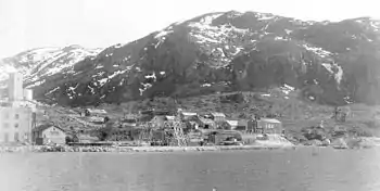
The town of Ivittuut is abandoned and the only settlement of the municipality is the permanent naval base Kangilinnguit (Grønnedal). The municipality existed de jure and was about to be absorbed by Narsaq when the 2009 municipal reform took place.
Kangilinnguit is the Danish naval headquarters of Greenland, originally established to protect Ivittuut's cryolite mine.
Climate
| Climate data for Ivittuut | |||||||||||||
|---|---|---|---|---|---|---|---|---|---|---|---|---|---|
| Month | Jan | Feb | Mar | Apr | May | Jun | Jul | Aug | Sep | Oct | Nov | Dec | Year |
| Average high °C (°F) | −4 (24) |
−3 (26) |
−1 (31) |
3 (38) |
8 (47) |
12 (54) |
14 (57) |
13 (55) |
8 (47) |
4 (40) |
0 (32) |
−3 (27) |
4 (40) |
| Average low °C (°F) | −11 (12) |
−11 (12) |
−9 (16) |
−4 (24) |
1 (33) |
4 (39) |
6 (42) |
5 (41) |
2 (36) |
−2 (29) |
−6 (22) |
−9 (16) |
−3 (27) |
| Average precipitation mm (inches) | 84 (3.3) |
66 (2.6) |
86 (3.4) |
64 (2.5) |
89 (3.5) |
81 (3.2) |
79 (3.1) |
94 (3.7) |
150 (5.9) |
140 (5.7) |
120 (4.6) |
79 (3.1) |
1,130 (44.6) |
| Source: Weatherbase [1] | |||||||||||||
External links
- www.arsukfjorden.gl Local web site with maps and other information.
References
- "Weatherbase: Historical Weather for Ivittuut, Greenland". Weatherbase. 2011. Retrieved on November 24, 2011.
Former administrative divisions of Greenland (until 31 December 2008) | ||
|---|---|---|
| Norse Greenland |
| |
| Danish colonies |
| |
| Counties |
| |
| Municipalities |
| |
| Unincorporated Areas |
| |
| See also | ||