Jaigaon
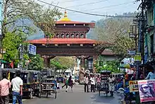
Jaigaon is a census town in Alipurduar subdivision of Alipurduar district in the state of West Bengal, India. It is located on the country's border with Bhutan. The main overland entrance to Bhutan is through Jaigaon and Bhutan Gate separates the two countries. Bhutan does not have domestic roads linking to all its towns, so Bhutan uses Indian roads passing through Jaigaon to reach such destinations as Samtse, Gomtu, Nganglam and Samdrup Jongkhar.
Jaigaon | |
|---|---|
Census Town | |
 Jaigaon from the kharbandi (Bhutan) | |
 Jaigaon Location in West Bengal, India,  Jaigaon Jaigaon (India) | |
| Coordinates: 26.83°N 89.38°E | |
| Country | |
| State | West Bengal |
| District | Alipurduar |
| Population (2011) | |
| • Total | 42,254 |
| Languages | |
| • Official | Bengali[1][2] |
| • Additional official | English[1] |
| Time zone | UTC+5:30 (IST) |
| PIN | 736182 |
| Vehicle registration | WB |
| Lok Sabha Constituency | Alipurduar (ST) |
| Vidhan Sabha constituency | Kalchini (ST) |
| Website | www www |
Geography
| Places and tea estates in the eastern portion of Alipurdar subdivision (including Kalchini, Kumargram and Alipuduar II CD blocks) in Alipurduar district CT: census town, R: rural/ urban centre, N: neighbourhood, A: Air Force Station, NP: national park/ wildlife sanctuary, TE: tea estate, H: historical site Abbreviations used in names – TG for Tea Garden (town/village), TE for Tea Estate Owing to space constraints in the small map, the actual locations in a larger map may vary slightly |
Location
Jaigaon is located at 26.83°N 89.38°E.[3]
Jaigaon has a hilly and sloppy terrain. The town is situated at the India-Bhutan border with Phuentsholing. There are several streams coming from the uphills and joining the river Toorsa at the downtown. Bagdogra Airport (Siliguri) is the nearest airport, and Kolkata its nearest port, where goods to Bhutan are brought from. Hasimara is the nearest railway station. National Highway 317A in India connects Jaigaon to Hasimara. India offers a free flow of goods from Kolkata port to Bhutan. It lies on the banks of the Torsa River.[4]
Area overview
Alipurduar district is covered by two maps. It is an extensive area in the eastern end of the Dooars in West Bengal. It is undulating country, largely forested, with numerous rivers flowing down from the outer ranges of the Himalayas in Bhutan. It is a predominantly rural area with 79.38% of the population living in the rural areas. The district has 1 municipal town and 20 census towns and that means that 20.62% of the population lives in the urban areas. The scheduled castes and scheduled tribes, taken together, form more than half the population in all the six community development blocks in the district. There is a high concentration of tribal people (scheduled tribes) in the three northern blocks of the district.[5][6][7]
Note: The map alongside presents some of the notable locations in the subdivision. All places marked in the map are linked in the larger full screen map.
Environment
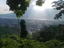
Jaigaon is in a small valley located near the low-lying hills of the Himalayan mountains. Jaigaon receives an abundant amount of rainfall throughout the year. The outskirts of the city are demarcated by tea gardens. The Torsa River flows at the lower end of the town. High levels of in-migration to Jaigaon from elsewhere in India has caused the environmental conditions of the city to deteriorate. To solve the problem of non-potable drinking water, various bore wells and pump stations operate around the town, adding to the problem of the decreasing water table below the town.
Demographic
As of census 2011 India census,[8] Jaigaon had a population of 42,254. Males constitute 51.2% of the population and females 48.8%. Jaigaon has an average literacy rate of 60.52%.
Education

Jaigaon has several schools under various education board of the country. Schools such as Sunrise English School which is one of the oldest and the most popular school in town, St. Anthony's Convent, B.D Memorial English Higher Secondary School, and St. John's follow the ICSE and ISC curriculum. SHMD School is the only CBSE school in the town. Schools like Ved Vyas, St. Dominic's and zenith school follow the state education board, whereas New Adarsh is an open board school. Recently Green View English School also start following the state board.
Nani Bhattacharya Smarak Mahavidyalaya is an affiliated college of North Bengal University located in the vicinity of Jaigaon, and offers degrees in a variety of fields.
Many students in Jaigaon opt to pursue higher education elsewhere in West Bengal, particularly Siliguri and Kolkata.
Culture
The lifestyle of Jaigaon is influenced by the town's diverse population of people from throughout India and Bhutan. The demand of Indian and Bhutanese consumers from nearby Phuentsholing has led to the development of the service sector in various fields.
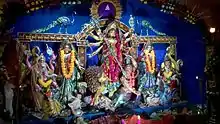
A variety of festivals of various religions are celebrated in Jaigaon, reflecting the town's diverse demographics.
The diversity of Jaigaon can be seen in its food and clothing, which represents diverse segments of Indian culture. In addition, the town's proximity to Bhutan has led to the popularity of Tibetan-influenced cuisine such as momos. In addition, ghos and kiras, the
Every year various sports and other tournaments are organised in Jaigaon by various trusts and NGOs. A cricket tournament is organised every year, and a marathon is organised every January. Apart from these, various inter-school debates, quizzes and sports meets are organised. On Independence Day, students from various schools participate in events organised by the Indian Consulate to Bhutan. Also on Republic Day every year, parades and cultural programs are organised in the town.
See also
- Phuntsholing, border town of Bhutan
- Bhutan-India Border
References
- "Fact and Figures". Wb.gov.in. Retrieved 10 March 2019.
- "52nd Report of the Commissioner for Linguistic Minorities in India" (PDF). Nclm.nic.in. Ministry of Minority Affairs. p. 85. Archived from the original (PDF) on 25 May 2017. Retrieved 10 March 2019.
- "Yahoo maps location of Jaigaon". Yahoo maps. Retrieved 7 December 2008.
- District-wise list of statutory towns Archived 19 March 2005 at the Wayback Machine
- "District Statistical Handbook 2014 Jalpaiguri". Tables 2.2, 2.4b. Department of Planning and Statistics, Government of West Bengal. Retrieved 29 June 2020.
- "CD block Wise Primary Census Abstract Data(PCA)". 2011 census: West Bengal – District-wise CD blocks. Registrar General and Census Commissioner, India. Retrieved 29 June 2020.
- "District Census Handbook, Jalpaiguri, Series 20, Part XIIA" (PDF). Census of India 2011, page 13 Physiography. Directorate of Census Operations, West Bengal. Retrieved 18 June 2020.
- "Census of India 2001: Data from the 2001 Census, including cities, villages and towns (Provisional)". Census Commission of India. Archived from the original on 16 June 2004. Retrieved 1 November 2008.
| Wikimedia Commons has media related to Jaigaon. |
Cities, towns and locations in Alipurduar district | |||
|---|---|---|---|
| Cities, municipal and census towns | |||
| Locations other than cities and towns | |||
| Specitic Tea Estates | |||
| Related Topics |
| ||