Jatznick
Jatznick is a municipality in the Vorpommern-Greifswald district, in Mecklenburg-Vorpommern, Germany.
Jatznick | |
|---|---|
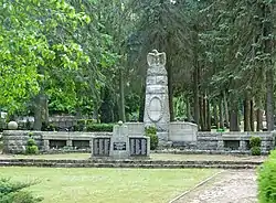
 War memorial in Jatznick | |
 Flag  Coat of arms | |
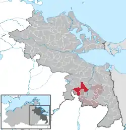
Location of Jatznick within Vorpommern-Greifswald district  | |
 Jatznick  Jatznick | |
| Coordinates: 53°35′N 13°56′E | |
| Country | Germany |
| State | Mecklenburg-Vorpommern |
| District | Vorpommern-Greifswald |
| Municipal assoc. | Uecker-Randow-Tal |
| Government | |
| • Mayor | Peter Fischer (Bürgerbündnis Uecker-Randow) |
| Area | |
| • Total | 62.03 km2 (23.95 sq mi) |
| Elevation | 22 m (72 ft) |
| Population (2019-12-31)[1] | |
| • Total | 2,230 |
| • Density | 36/km2 (93/sq mi) |
| Time zone | UTC+01:00 (CET) |
| • Summer (DST) | UTC+02:00 (CEST) |
| Postal codes | 17309 |
| Dialling codes | 039741 |
| Vehicle registration | VG |
| Website | www.jatznick.de |
Geography
With almost 2000 inhabitants, Jatznick is the largest municipality in the Uecker-Randow-Tal district. It is situated on the north-eastern edge of the Nördliche Höhenrücken, a terminal moraine that extends about 25 kilometres to the west (highest elevation in the Brohmer Berge 153 metres above sea level). North and east of Jatznick, the landscape becomes very flat (Ueckermünder Heide to the Stettiner Haff as well as the lowlands of the Friedländer Große Wiese). At Waldeshöhe there is the Aalsee, a water body of about 0.8 hectares.
Districts
- Am Bahnhof
- Blumenhagen
- Belling (incorporation on 1 January 2001)[2]
- Groß Spiegelberg
- Klein Luckow
- Sandförde with Wilhelmsthal
- Waldeshöhe
History
1354 the village Jatznick is mentioned for the first time in a document. The place was originally inhabited by Slavs, who gave the place its present name.
On July 1, 1950 the until then independent community of Waldeshöhe was incorporated.
On 1 January 2012 the formerly independent communities of Blumenhagen and Klein Luckow were incorporated into Jatznick.[3]
Transport
Jatznick railway station connects the area with Stralsund, Greifswald, Züssow, Angermünde, Eberswalde, Berlin, Ueckermünde and Neubrandenburg.
References
- "Statistisches Amt M-V – Bevölkerungsstand der Kreise, Ämter und Gemeinden 2019". Statistisches Amt Mecklenburg-Vorpommern (in German). July 2020.
- StBA: Änderungen bei den Gemeinden Deutschlands, siehe 2001
- Gebietsänderungen, Statistisches Landesamt Mecklenburg-Vorpommern