Koblentz
Koblentz is a municipality in the Vorpommern-Greifswald district, in Mecklenburg-Vorpommern, Germany.
Koblentz | |
|---|---|
Location of Koblentz within Vorpommern-Greifswald district 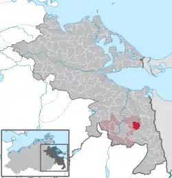 | |
 Koblentz  Koblentz | |
| Coordinates: 53°31′N 14°08′E | |
| Country | Germany |
| State | Mecklenburg-Vorpommern |
| District | Vorpommern-Greifswald |
| Municipal assoc. | Uecker-Randow-Tal |
| Government | |
| • Mayor | Ingelore Grygula |
| Area | |
| • Total | 22.99 km2 (8.88 sq mi) |
| Elevation | 14 m (46 ft) |
| Population (2019-12-31)[1] | |
| • Total | 211 |
| • Density | 9.2/km2 (24/sq mi) |
| Time zone | UTC+01:00 (CET) |
| • Summer (DST) | UTC+02:00 (CEST) |
| Postal codes | 17309 |
| Dialling codes | 039743, 039748 |
| Vehicle registration | VG |
| Website | www.amt-uecker-randow-tal.de |
Climate
Köppen-Geiger climate classification system classifies its climate as oceanic (Cfb).[2]
| Climate data for Koblentz | |||||||||||||
|---|---|---|---|---|---|---|---|---|---|---|---|---|---|
| Month | Jan | Feb | Mar | Apr | May | Jun | Jul | Aug | Sep | Oct | Nov | Dec | Year |
| Average high °C (°F) | 0.9 (33.6) |
2.1 (35.8) |
7 (45) |
12.8 (55.0) |
18.2 (64.8) |
21.7 (71.1) |
23 (73) |
22.9 (73.2) |
18.9 (66.0) |
13 (55) |
6.9 (44.4) |
3 (37) |
12.5 (54.5) |
| Daily mean °C (°F) | −1.4 (29.5) |
−0.6 (30.9) |
3.5 (38.3) |
8.4 (47.1) |
13.1 (55.6) |
16.8 (62.2) |
18.3 (64.9) |
18.1 (64.6) |
14.6 (58.3) |
9.8 (49.6) |
4.5 (40.1) |
0.9 (33.6) |
8.8 (47.9) |
| Average low °C (°F) | −3.7 (25.3) |
−3.3 (26.1) |
0 (32) |
4 (39) |
8.1 (46.6) |
11.9 (53.4) |
13.7 (56.7) |
13.3 (55.9) |
10.3 (50.5) |
6.6 (43.9) |
2.1 (35.8) |
−1.2 (29.8) |
5.1 (41.3) |
| Average precipitation mm (inches) | 38 (1.5) |
29 (1.1) |
33 (1.3) |
38 (1.5) |
50 (2.0) |
59 (2.3) |
63 (2.5) |
56 (2.2) |
48 (1.9) |
41 (1.6) |
45 (1.8) |
43 (1.7) |
543 (21.4) |
| Source: Climate-Data.org (altitude: 7m)[2] | |||||||||||||
References
- "Statistisches Amt M-V – Bevölkerungsstand der Kreise, Ämter und Gemeinden 2019". Statistisches Amt Mecklenburg-Vorpommern (in German). July 2020.
- "Temperature, Climate graph, Climate table for Koblentz". Climate-Data.org. Retrieved 2017-09-25.
| Authority control |
|---|
This article is issued from Wikipedia. The text is licensed under Creative Commons - Attribution - Sharealike. Additional terms may apply for the media files.