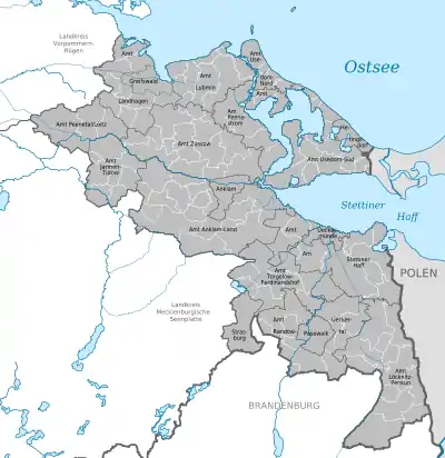
Vorpommern-Greifswald
Vorpommern-Greifswald is a district in the east of Mecklenburg-Vorpommern, Germany. It is bounded by (from the west and clockwise) the districts of Mecklenburgische Seenplatte and Vorpommern-Rügen, the Baltic Sea, Poland (West Pomeranian Voivodeship) and the state of Brandenburg. The district seat is the University and Hanseatic City of Greifswald.[2] A lake called Berliner See is found in the district.
Vorpommern-Greifswald | |
|---|---|
 Coat of arms | |

| |
| Country | Germany |
| State | Mecklenburg-Vorpommern |
| Capital | Greifswald |
| Area | |
| • Total | 3,927 km2 (1,516 sq mi) |
| Population (31 December 2019)[1] | |
| • Total | 235,623 |
| • Density | 60/km2 (160/sq mi) |
| Time zone | UTC+01:00 (CET) |
| • Summer (DST) | UTC+02:00 (CEST) |
| Vehicle registration | VG, ANK, GW, PW, SBG, UEM, WLG Greifswald: HGW |
| Website | www.kreis-vg.de |
History
Vorpommern-Greifswald District was established by merging the former districts of Ostvorpommern and Uecker-Randow; along with the subdivisions of Jarmen-Tutow and Peenetal/Loitz (from the former district of Demmin), and the former district-free town Greifswald, as part of the local government reform of September 2011.[2] The name of the district was decided by referendum on 4 September 2011.[3] The project name for the district was Südvorpommern.
Geography
The district has a number of lakes including:
| Lake Name | Elevation | Surface Area |
|---|---|---|
| Berliner See | 7.5 m (25 ft) | 0.062 km2 (0.024 sq mi) |
| Demenzsee | 49 m (161 ft) | 0.18 km2 (0.069 sq mi) |
| Großer Mützelburger See | 4.5 m (15 ft) | 1.14 km2 (0.44 sq mi) |
| Großer See (Pinnow) | 10 m (33 ft) | 0.64 km2 (0.25 sq mi) |
| Hoher See | 10.8 m (35 ft) | 0.102 km2 (0.039 sq mi) |
| Küchensee | 11.6 m (38 ft) | 0.094 km2 (0.036 sq mi) |
| Ludwigshofer See | 2.8 m (9.2 ft) | 0.18 km2 (0.069 sq mi) |
| Pulower See | 10.9 m (36 ft) | 0.103 km2 (0.040 sq mi) |
| Putzarer See | 7.3 m (24 ft) | 1.68 km2 (0.65 sq mi) |
| Schloßsee | −0.5 m (−1.6 ft) | 0.1 km2 (0.039 sq mi) |
| Straßensee | 10.9 m (36 ft) | 0.131 km2 (0.051 sq mi) |
| Zarrenthiner Kiessee | 7.2 m (24 ft) | 0.54 km2 (0.21 sq mi) |
The island of Usedom within the district also has a number of lakes.
Towns and municipalities

| Amt-free towns | Amt-free municipalities |
|---|---|
References
- "Statistisches Amt M-V – Bevölkerungsstand der Kreise, Ämter und Gemeinden 2019". Statistisches Amt Mecklenburg-Vorpommern (in German). July 2020.
- "Mecklenburg-Vorpommern government reform". Retrieved 5 September 2011.
- "Referendum results Mittleres Mecklenburg". Retrieved 5 September 2011.
External links
| Wikimedia Commons has media related to Landkreis Vorpommern-Greifswald. |
- Official website of Vorpommern-Greifswald district (includes translator)
| Urban districts | ||
|---|---|---|
| Rural districts | ||
| Authority control |
|---|