Jefferson, Greene County, Pennsylvania
Jefferson is a borough in Greene County, Pennsylvania, United States. The population was 270 at the 2010 census,[3] down from 337 at the 2000 census. The borough was named after Thomas Jefferson.[4]
Jefferson, Greene County, Pennsylvania | |
|---|---|
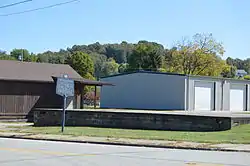 Site of the former Monongahela College on Pennsylvania Route 188 | |
| Etymology: Thomas Jefferson | |
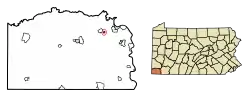 Location of Jefferson in Greene County, Pennsylvania. | |
 Jefferson Location of Jefferson in Greene County, Pennsylvania.  Jefferson Jefferson (the United States) | |
| Coordinates: 39°55′49″N 80°3′32″W | |
| Country | United States |
| State | Pennsylvania |
| County | Greene |
| Established | 1795 |
| Government | |
| • Mayor | Joshua Forman |
| Area | |
| • Total | 0.19 sq mi (0.49 km2) |
| • Land | 0.19 sq mi (0.49 km2) |
| • Water | 0.00 sq mi (0.00 km2) |
| Elevation | 960 ft (290 m) |
| Population (2010) | |
| • Total | 270 |
| • Estimate (2019)[2] | 253 |
| • Density | 1,345.74/sq mi (519.89/km2) |
| Time zone | UTC-4 (EST) |
| • Summer (DST) | UTC-5 (EDT) |
| ZIP code | 15344 |
| Area code(s) | 724 |
| FIPS code | 42-37880 |
Geography
Jefferson is located in northeastern Greene County at 39°55′49″N 80°3′32″W (39.930322, -80.058993).[5] It is surrounded by Jefferson Township, a separate municipality. Pennsylvania Route 188 (Jefferson Road) passes through the center of the borough, leading east 3 miles (5 km) to Dry Tavern and west 7 miles (11 km) to Waynesburg, the county seat.
According to the United States Census Bureau, the borough has a total area of 0.19 square miles (0.49 km2), all of it land. The South Fork of Tenmile Creek passes just north of the borough.
Demographics
| Historical population | |||
|---|---|---|---|
| Census | Pop. | %± | |
| 1880 | 347 | — | |
| 1890 | 327 | −5.8% | |
| 1900 | 311 | −4.9% | |
| 1910 | 357 | 14.8% | |
| 1920 | 392 | 9.8% | |
| 1930 | 528 | 34.7% | |
| 1940 | 557 | 5.5% | |
| 1950 | 575 | 3.2% | |
| 1960 | 442 | −23.1% | |
| 1970 | 366 | −17.2% | |
| 1980 | 413 | 12.8% | |
| 1990 | 355 | −14.0% | |
| 2000 | 337 | −5.1% | |
| 2010 | 270 | −19.9% | |
| 2019 (est.) | 253 | [2] | −6.3% |
| Sources:[6][7][8] | |||
As of the census[7] of 2000, there were 337 people, 139 households, and 97 families residing in the borough. The population density was 1,801.8 people per square mile (684.8/km²). There were 147 housing units at an average density of 786.0/sq mi (298.7/km²). The racial makeup of the borough was 99.41% White, 0.30% African American, and 0.30% from two or more races.
There were 139 households, out of which 30.2% had children under the age of 18 living with them, 52.5% were married couples living together, 11.5% had a female householder with no husband present, and 30.2% were non-families. 25.9% of all households were made up of individuals, and 14.4% had someone living alone who was 65 years of age or older. The average household size was 2.42 and the average family size was 2.91.
In the borough the population was spread out, with 25.2% under the age of 18, 4.7% from 18 to 24, 26.7% from 25 to 44, 22.8% from 45 to 64, and 20.5% who were 65 years of age or older. The median age was 41 years. For every 100 females there were 93.7 males. For every 100 females age 18 and over, there were 89.5 males.
The median income for a household in the borough was $33,750, and the median income for a family was $40,893. Males had a median income of $28,958 versus $14,219 for females. The per capita income for the borough was $15,294. About 8.9% of families and 7.8% of the population were below the poverty line, including 3.8% of those under age 18 and 16.7% of those age 65 or over.
References
- "2019 U.S. Gazetteer Files". United States Census Bureau. Retrieved July 28, 2020.
- "Population and Housing Unit Estimates". United States Census Bureau. May 24, 2020. Retrieved May 27, 2020.
- "Geographic Identifiers: 2010 Demographic Profile Data (G001): Jefferson borough (Greene County), Pennsylvania". American Factfinder. U.S. Census Bureau. Retrieved January 27, 2017.
- Ackerman, Jan (May 10, 1984). "Town names carry bit of history". Pittsburgh Post-Gazette. p. 1. Retrieved 31 October 2015.
- "US Gazetteer files: 2010, 2000, and 1990". United States Census Bureau. 2011-02-12. Retrieved 2011-04-23.
- "Census of Population and Housing". U.S. Census Bureau. Retrieved 11 December 2013.
- "U.S. Census website". United States Census Bureau. Retrieved 2008-01-31.
- "Incorporated Places and Minor Civil Divisions Datasets: Subcounty Resident Population Estimates: April 1, 2010 to July 1, 2012". Population Estimates. U.S. Census Bureau. Archived from the original on 17 June 2013. Retrieved 11 December 2013.
Municipalities and communities of Greene County, Pennsylvania, United States | ||
|---|---|---|
| Boroughs |  | |
| Townships | ||
| CDPs | ||
| Unincorporated communities | ||
| ||
| Authority control |
|
|---|