Greene County, Pennsylvania
Greene County is a county located in the U.S. state of Pennsylvania. As of the 2010 census, the population was 38,686.[1] Its county seat is Waynesburg.[2] Greene County was created on February 9, 1796, from part of Washington County and named for General Nathanael Greene.
Greene County | |
|---|---|
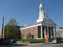 Greene County Courthouse | |
 Seal | |
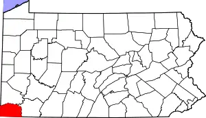 Location within the U.S. state of Pennsylvania | |
 Pennsylvania's location within the U.S. | |
| Coordinates: 39°52′N 80°13′W | |
| Country | |
| State | |
| Founded | February 9, 1796 |
| Named for | Nathanael Greene |
| Seat | Waynesburg |
| Largest borough | Waynesburg |
| Area | |
| • Total | 578 sq mi (1,500 km2) |
| • Land | 576 sq mi (1,490 km2) |
| • Water | 2.0 sq mi (5 km2) 0.4%% |
| Population | |
| • Estimate (2018) | 36,506 |
| • Density | 65/sq mi (25/km2) |
| Time zone | UTC−5 (Eastern) |
| • Summer (DST) | UTC−4 (EDT) |
| Congressional district | 14th |
| Website | www |
Greene County is part of the Pittsburgh media market. It is located in the area of southwestern Pennsylvania that was formerly claimed by Virginia, the District of West Augusta.
Geography
According to the U.S. Census Bureau, the county has a total area of 578 square miles (1,500 km2), of which 576 square miles (1,490 km2) is land and 2.0 square miles (5.2 km2) (0.4%) is water.[3] It has a humid continental climate (Dfa/Dfb) and average monthly temperatures in Waynesburg range from 28.9 °F in January to 71.9 °F in July.
Adjacent counties
- Washington County (north)
- Fayette County (east)
- Monongalia County, West Virginia (south)
- Wetzel County, West Virginia (southwest)
- Marshall County, West Virginia (west)
Demographics
| Historical population | |||
|---|---|---|---|
| Census | Pop. | %± | |
| 1800 | 8,605 | — | |
| 1810 | 12,544 | 45.8% | |
| 1820 | 15,554 | 24.0% | |
| 1830 | 18,028 | 15.9% | |
| 1840 | 19,147 | 6.2% | |
| 1850 | 22,136 | 15.6% | |
| 1860 | 24,343 | 10.0% | |
| 1870 | 25,887 | 6.3% | |
| 1880 | 28,273 | 9.2% | |
| 1890 | 28,935 | 2.3% | |
| 1900 | 28,281 | −2.3% | |
| 1910 | 28,882 | 2.1% | |
| 1920 | 30,804 | 6.7% | |
| 1930 | 41,767 | 35.6% | |
| 1940 | 44,671 | 7.0% | |
| 1950 | 45,394 | 1.6% | |
| 1960 | 39,457 | −13.1% | |
| 1970 | 39,108 | −0.9% | |
| 1980 | 42,253 | 8.0% | |
| 1990 | 44,164 | 4.5% | |
| 2000 | 40,672 | −7.9% | |
| 2010 | 38,686 | −4.9% | |
| 2018 (est.) | 36,506 | [4] | −5.6% |
| U.S. Decennial Census[5] 1790-1960[6] 1900-1990[7] 1990-2000[8] 2010-2017[1] | |||
As of the census[9] of 2010, there were 38,686 people, 14,724 households, and 9,970 families residing in the county. The population density was 67 people per square mile (25.9/km2). There were 16,678 housing units at an average density of 29 per square mile (11/km2). The racial makeup of the county was 94.6 percent White, 3.3 percent Black or African American, 0.2% Native American, 0.3 percent Asian, 0.0 percent Pacific Islander, 0.7 percent from other races, and 1.0% from two or more races. 1.2 percent of the population were Hispanic or Latino of any race.
There were 14,724 households, out of which 29.3 percent had children under the age of 18 living with them, 51.5 percent were married couples living together, 10.9 percent had a female householder with no husband present, and 32.3 percent were non-families. 27.0 percent of all households were made up of individuals, and 11.7 percent had someone living alone who was 65 years of age or older. The average household size was 2.42 and the average family size was 2.91.
In the county, the population was spread out, with 19.9 percent under the age of 18, 9.9 percent from 18 to 24, 25.5 percent from 25 to 44, 29.3 percent from 45 to 64, and 15.3 percent who were 65 years of age or older. The median age was 41.1 years. For every 100 females there were 106.2 males. For every 100 females age 18 and over, there were 105.6 males.
Government and politics
Greene County was long a Democratic stronghold, due to the strong unionization of the county's steel mills; between 1932 and 2000, the Democratic presidential candidate won the county in every election except in the Republican landslide of 1972. Due to the decline of the Pittsburgh area's steel industry (in lockstep with most other Appalachian counties), and the Democratic Party's shift on cultural issues like the environment and guns, the county has shifted towards the Republican Party, and in 2016 Donald Trump won the county with 68.4% of the vote.
| Year | Republican | Democratic | Third parties |
|---|---|---|---|
| 2020 | 71.2% 12,579 | 27.8% 4,911 | 1.0% 179 |
| 2016 | 68.4% 10,849 | 28.3% 4,482 | 3.4% 537 |
| 2012 | 57.9% 8,428 | 40.2% 5,852 | 1.8% 266 |
| 2008 | 49.0% 7,889 | 48.6% 7,829 | 2.5% 396 |
| 2004 | 50.0% 7,786 | 49.3% 7,674 | 0.7% 105 |
| 2000 | 43.1% 5,890 | 53.0% 7,230 | 3.9% 533 |
| 1996 | 29.1% 4,002 | 55.5% 7,620 | 15.4% 2,114 |
| 1992 | 23.0% 3,482 | 55.8% 8,438 | 21.2% 3,215 |
| 1988 | 34.6% 4,879 | 64.8% 9,126 | 0.6% 90 |
| 1984 | 40.4% 6,376 | 59.3% 9,365 | 0.3% 43 |
| 1980 | 37.8% 5,336 | 58.0% 8,193 | 4.2% 592 |
| 1976 | 37.2% 5,293 | 61.7% 8,769 | 1.1% 157 |
| 1972 | 57.5% 7,790 | 41.1% 5,562 | 1.4% 191 |
| 1968 | 35.4% 5,099 | 56.9% 8,198 | 7.7% 1,104 |
| 1964 | 25.4% 3,896 | 74.5% 11,412 | 0.1% 19 |
| 1960 | 43.7% 7,498 | 56.2% 9,645 | 0.1% 16 |
| 1956 | 43.5% 7,562 | 56.5% 9,827 | 0.1% 14 |
| 1952 | 40.7% 6,964 | 59.1% 10,125 | 0.2% 30 |
| 1948 | 36.5% 4,717 | 62.0% 8,015 | 1.6% 202 |
| 1944 | 40.5% 5,747 | 59.1% 8,392 | 0.4% 53 |
| 1940 | 39.6% 6,726 | 60.2% 10,214 | 0.2% 36 |
| 1936 | 34.4% 6,359 | 65.0% 12,006 | 0.6% 109 |
| 1932 | 33.4% 4,808 | 64.8% 9,322 | 1.8% 258 |
| 1928 | 56.2% 6,910 | 43.0% 5,293 | 0.8% 96 |
| 1924 | 41.8% 4,590 | 53.5% 5,874 | 4.7% 512 |
| 1920 | 42.4% 4,253 | 55.8% 5,592 | 1.8% 183 |
| 1916 | 33.9% 2,096 | 63.6% 3,930 | 2.4% 151 |
| 1912 | 19.0% 1,150 | 58.7% 3,551 | 22.3% 1,351 |
| 1908 | 37.2% 2,438 | 57.9% 3,793 | 4.9% 319 |
| 1904 | 41.3% 2,442 | 54.1% 3,198 | 4.6% 270 |
| 1900 | 39.0% 2,427 | 59.1% 3,674 | 1.9% 119 |
| 1896 | 36.4% 2,453 | 62.3% 4,198 | 1.3% 86 |
| 1892 | 33.4% 2,126 | 62.5% 3,977 | 4.2% 264 |
| 1888 | 35.8% 2,373 | 62.1% 4,116 | 2.1% 141 |
Voter registration
As of November 7, 2017, there were 21,671 registered voters in the county. Democrats hold a majority of 3,621 voters (16.71%); there was 11,659 registered Democrats, 8,038 registered Republicans, 1,858 voters registered to other parties, 64 to the Libertarian Party and 52 voters registered to the Green Party.[11]
Chart of Voter Registration
| Voter registration and party enrollment | |||||
|---|---|---|---|---|---|
| Party | Number of voters | Percentage | |||
| Democratic | 11,659 | 53.80 | |||
| Republican | 8,038 | 37.09 | |||
| Others | 1,858 | 8.57 | |||
| Libertarian | 64 | 0.30 | |||
| Green | 52 | 0.24 | |||
| Total | 21,671 | 100% | |||
County commissioners
- Mike Belding, Republican[12]
- Betsy McClure, Republican
- Blair Zimmerman, Democrat
Other county officials
- President Judge, Hon. Farley Toothman
- Associate Judge, Hon. Louis Dayich
- District Attorney, David Russo, Republican
- Sheriff, Marcus Simms, Democrat
- Coroner, Gene Rush, Republican
- Clerk of Courts, Sherry Wise, Democrat
- Prothonotary, Susan White, Democrat
- Recorder of Deeds and Register of Wills, Donna Tharp, Democrat
- Treasurer, Cory Grandel, Democrat
- Controller, Ami Cree, Democrat
State Representative
- Pam Snyder, Democrat, 50th district[13]
State Senator
- Camera Bartolotta, Republican, 46th district[13]
US Representative
United States Senate
Economy
Greene County's development commission has assisted area business since 1998.[14]
The Meadow Ridge office park has served the county since the early 2000s.[15]
Education
Colleges and universities
Public school districts
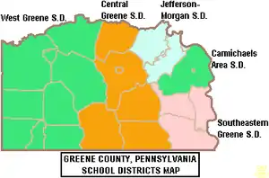
Greene County is divided into five (5) public school districts.[16] There are 15 public schools that serve Greene County, Pennsylvania.[17]
- Carmichaels Area School District
- Central Greene School District
- Jefferson-Morgan School District
- Southeastern Greene School District
- West Greene School District
Some schools within the five above districts include:
Private schools
- Open Door Christian School in Waynesburg (grades K-12)[18][19]
- Greene Valley Christian Academy in Rices Landing (grades K-8)[20]
Libraries
- Eva K Bowlby Public Library in Waynesburg
- Flenniken Public Library in Carmichaels, Pennsylvania
- Greene County Library System in Jefferson, Pennsylvania
Transportation
Interstate Highways
 I-79
I-79
Airport
Greene County Airport is a county-owned, public-use airport located two nautical miles (4 km) east of the central business district of Waynesburg, Pennsylvania.[21]
Communities
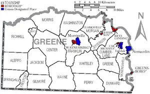
Under Pennsylvania law, there are four types of incorporated municipalities: cities, boroughs, townships, and, in at most two cases, towns. The following boroughs and townships are located in Greene County:
Boroughs
- Carmichaels
- Clarksville
- Greensboro
- Jefferson
- Rices Landing
- Waynesburg (county seat)
Townships
Census-designated places
Census-designated places are geographical areas designated by the U.S. Census Bureau for the purposes of compiling demographic data. They are not actual jurisdictions under Pennsylvania law. Other unincorporated communities, such as villages, may be listed here as well.
Population ranking
The population ranking of the following table is based on the 2010 census of Greene County.[22]
† county seat
| Rank | City/Town/etc. | Municipal type | Population (2010 Census) |
|---|---|---|---|
| 1 | † Waynesburg | Borough | 4,176 |
| 2 | Fairdale | CDP | 2,059 |
| 3 | Morrisville | CDP | 1,265 |
| 4 | Nemacolin | CDP | 937 |
| 5 | Bobtown | CDP | 757 |
| T-6 | Mather | CDP | 737 |
| T-6 | Mount Morris | CDP | 737 |
| 7 | Crucible | CDP | 725 |
| 8 | Dry Tavern | CDP | 697 |
| 9 | Carmichaels | Borough | 483 |
| 10 | Rices Landing | Borough | 463 |
| 11 | West Waynesburg | CDP | 446 |
| 12 | Jefferson | Borough | 270 |
| 13 | Greensboro | Borough | 260 |
| 14 | Rogersville | CDP | 249 |
| 15 | Clarksville | Borough | 230 |
| 16 | Wind Ridge | CDP | 215 |
| 17 | Brave | CDP | 201 |
| 18 | Mapletown | CDP | 130 |
| 19 | New Freeport | CDP | 112 |
See also
References
- "State & County QuickFacts". United States Census Bureau. Archived from the original on June 6, 2011. Retrieved November 17, 2013.
- "Find a County". National Association of Counties. Archived from the original on 2011-05-31. Retrieved 2011-06-07.
- "2010 Census Gazetteer Files". United States Census Bureau. August 22, 2012. Retrieved March 7, 2015.
- "Population and Housing Unit Estimates". Retrieved October 6, 2018.
- "U.S. Decennial Census". United States Census Bureau. Retrieved March 7, 2015.
- "Historical Census Browser". University of Virginia Library. Retrieved March 7, 2015.
- Forstall, Richard L., ed. (March 24, 1995). "Population of Counties by Decennial Census: 1900 to 1990". United States Census Bureau. Retrieved March 7, 2015.
- "Census 2000 PHC-T-4. Ranking Tables for Counties: 1990 and 2000" (PDF). United States Census Bureau. April 2, 2001. Retrieved March 7, 2015.
- "U.S. Census website". United States Census Bureau. Retrieved 2008-01-31.
- Leip, David. "Dave Leip's Atlas of U.S. Presidential Elections". uselectionatlas.org. Retrieved 26 November 2018.
- "Commonwealth of Pennsylvania, 2017 Voter Registration Statistics - Official" (PDF). 2017 Election VR Stats.pdf. November 7, 2017. Retrieved 2018-11-26.
- Thornberg, Ruth. "County Commissioners, Greene County Government, Pennsylvania". www.co.greene.pa.us. Retrieved 26 November 2018.
- Center, Legislativate Data Processing. "Find Your Legislator". The official website for the Pennsylvania General Assembly. Retrieved 2017-05-11.
- Klopfer, Milt (September 2, 1998), "Team targets growth", Observer-Reporter, Washington, PA
- "Robert Stephenson Named as President of RIDC; Frank Brooks Robinson, Sr. Steps Down", PR Newswire, April 17, 2003
- Thornberg, Ruth. "Education & Schools - Official Website for Greene County Government, Pennsylvania". www.co.greene.pa.us. Retrieved 26 November 2018.
- "Top Greene County, PA Private Schools (2018-19)". www.privateschoolreview.com. Retrieved 26 November 2018.
- "Open Door Christian School Profile (2018-19) - Waynesburg, PA". Private School Review. Retrieved 26 November 2018.
- "Explore Open Door Christian School in Waynesburg, PA". GreatSchools.org. Retrieved 26 November 2018.
- "Explore Greene Valley Christian Academ in Rices Landing, PA". GreatSchools.org. Retrieved 26 November 2018.
- FAA Airport Form 5010 for WAY PDF. Federal Aviation Administration. Effective May 31, 2012.
- "2010 U.S. Census website". United States Census Bureau. Retrieved 2013-02-10.
External links
Places adjacent to Greene County, Pennsylvania | ||||||||||
|---|---|---|---|---|---|---|---|---|---|---|
| ||||||||||
Municipalities and communities of Greene County, Pennsylvania, United States | ||
|---|---|---|
| Boroughs | | |
| Townships | ||
| CDPs | ||
| Unincorporated communities | ||
| ||

| Authority control |
|---|