Jefferson Township, Adams County, Ohio
Jefferson Township is one of the fifteen townships of Adams County, Ohio, United States. As of the 2010 census the population was 1,046.[3]
Jefferson Township, Adams County, Ohio | |
|---|---|
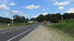 Approaching Blue Creek | |
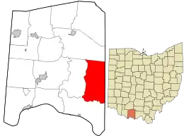 Location in Adams County and the state of Ohio. | |
| Coordinates: 38°47′44″N 83°18′51″W | |
| Country | United States |
| State | Ohio |
| County | Adams |
| Area | |
| • Total | 43.1 sq mi (111.7 km2) |
| • Land | 43.1 sq mi (111.5 km2) |
| • Water | 0.04 sq mi (0.1 km2) |
| Elevation | 640 ft (195 m) |
| Population (2010) | |
| • Total | 1,046 |
| • Density | 24/sq mi (9.4/km2) |
| Time zone | UTC-5 (Eastern (EST)) |
| • Summer (DST) | UTC-4 (EDT) |
| FIPS code | 39-38486[2] |
| GNIS feature ID | 1085678[1] |
Geography
Located in the eastern part of the county, it borders the following townships:
- Meigs Township - north
- Brush Creek Township, Scioto County - northeast
- Nile Township, Scioto County - southeast
- Green Township - south
- Brush Creek Township - west
No municipalities are located in Jefferson Township, although the unincorporated community of Blue Creek lies in the township's west.
History
Jefferson Township was organized in 1806. It is named for Thomas Jefferson.[4]
It is one of twenty-four Jefferson Townships statewide.[5]
Government
The township is governed by a three-member board of trustees, who are elected in November of odd-numbered years to a four-year term beginning on the following January 1. Two are elected in the year after the presidential election and one is elected in the year before it. There is also an elected township fiscal officer,[6] who serves a four-year term beginning on April 1 of the year after the election, which is held in November of the year before the presidential election. Vacancies in the fiscal officership or on the board of trustees are filled by the remaining trustees.
Notable people
- Lloyd Estel Copas, American country music singer, better known by his stage name, Cowboy Copas
References
- "US Board on Geographic Names". United States Geological Survey. 2007-10-25. Retrieved 2008-01-31.
- "U.S. Census website". United States Census Bureau. Retrieved 2008-01-31.
- "Geographic Identifiers: 2010 Demographic Profile Data (G001): Jefferson township, Adams County, Ohio". U.S. Census Bureau, American Factfinder. Archived from the original on February 12, 2020. Retrieved July 5, 2013.
- Evans, Nelson Wiley (1900). A History of Adams County, Ohio: From Its Earliest Settlement to the Present Time. E B. Stivers. pp. 428.
- "Detailed map of Ohio" (PDF). United States Census Bureau. 2000. Retrieved 2007-02-16.
- §503.24, §505.01, and §507.01 of the Ohio Revised Code. Accessed 4/30/2009.
External links
Municipalities and communities of Adams County, Ohio, United States | ||
|---|---|---|
| Villages |  Map of Ohio highlighting Adams County | |
| Townships | ||
| CDPs | ||
| Unincorporated communities |
| |
| ||
| Authority control |
|
|---|