Adams County, Ohio
Adams County is a county in the U.S. state of Ohio. As of the 2010 census, the population was 28,550.[2] Its county seat is West Union.[3] The county is named after John Adams, the second President of the United States.[4]
Adams County | |
|---|---|
 | |
 Seal | |
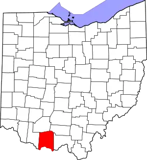 Location within the U.S. state of Ohio | |
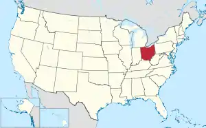 Ohio's location within the U.S. | |
| Coordinates: 38°50′N 83°29′W | |
| Country | |
| State | |
| Founded | July 10, 1797[1] |
| Named for | John Adams |
| Seat | West Union |
| Largest village | West Union |
| Area | |
| • Total | 586 sq mi (1,520 km2) |
| • Land | 584 sq mi (1,510 km2) |
| • Water | 2.4 sq mi (6 km2) 0.4%% |
| Population | |
| • Estimate (2019) | 27,698 |
| • Density | 49/sq mi (19/km2) |
| Time zone | UTC−5 (Eastern) |
| • Summer (DST) | UTC−4 (EDT) |
| Congressional district | 2nd |
| Website | adamscountyoh |
Geography
According to the U.S. Census Bureau, the county has an area of 586 square miles (1,520 km2), of which 584 square miles (1,510 km2) is land and 2.4 square miles (6.2 km2) (0.4%) is water.[5] It includes many parks and preserves, including one of Ohio's greatest archeological wonders, the Serpent Mound at the Serpent Mound State Memorial in Locust Grove. Serpent Mound lends its name to the Serpent Mound crater, the eroded remnant of a huge ancient meteorite impact crater. Other areas of note include state parks and national forests like Edge of Appalachia, Shawnee State Park, Adams Lake State Park and Robert H. Whipple State Nature Preserve.[6]
Adjacent counties
- Highland County (north)
- Pike County (northeast)
- Scioto County (east)
- Lewis County, Kentucky (south)
- Mason County, Kentucky (southwest)
- Brown County (west)
State protected areas
- Adams Lake State Park
- Chaparral Prairie State Nature Preserve
- Davis Memorial State Nature Preserve
- Johnson Ridge State Nature Preserve
- Lynx Prairie
- Shoemaker State Nature Preserve
- Whipple State Nature Preserve
Demographics
| Historical population | |||
|---|---|---|---|
| Census | Pop. | %± | |
| 1800 | 3,432 | — | |
| 1810 | 9,434 | 174.9% | |
| 1820 | 10,406 | 10.3% | |
| 1830 | 12,281 | 18.0% | |
| 1840 | 13,183 | 7.3% | |
| 1850 | 18,883 | 43.2% | |
| 1860 | 20,309 | 7.6% | |
| 1870 | 20,750 | 2.2% | |
| 1880 | 24,005 | 15.7% | |
| 1890 | 26,093 | 8.7% | |
| 1900 | 26,328 | 0.9% | |
| 1910 | 24,755 | −6.0% | |
| 1920 | 22,403 | −9.5% | |
| 1930 | 20,381 | −9.0% | |
| 1940 | 21,705 | 6.5% | |
| 1950 | 20,499 | −5.6% | |
| 1960 | 19,982 | −2.5% | |
| 1970 | 18,957 | −5.1% | |
| 1980 | 24,328 | 28.3% | |
| 1990 | 25,371 | 4.3% | |
| 2000 | 27,330 | 7.7% | |
| 2010 | 28,550 | 4.5% | |
| 2019 (est.) | 27,698 | [2][7] | −3.0% |
| U.S. Decennial Census[8] 1790-1960[9] 1900-1990[10] 1990-2000[11] 2010-2019[2] | |||
2000 census
As of the census[12] of 2000, 27,330 people, 10,501 households, and 7,613 families resided in the county. The population density was 47 people per square mile (18/km2). There were 11,822 housing units at an average density of 20 per square mile (8/km2). The racial makeup of the county was 97.77% White, 0.18% Black or African American, 0.68% Native American, 0.12% Asian, 0.03% Pacific Islander, 0.11% from other races, and 1.10% from two or more races. 0.64% of the population were Hispanic or Latino of any race. 38.5% were of American, 19.8% German, 11.7% Irish and 8.9% English ancestry according to Census 2000.
There were 10,501 households, out of which 34.00% had children under the age of 18 living with them, 57.10% were married couples living together, 10.40% had a female householder with no husband present, and 27.50% were non-families. 24.00% of all households were made up of individuals, and 11.00% had someone living alone who was 65 years of age or older. The average household size was 2.57 and the average family size was 3.03.
In the county, the population was spread out, with 26.40% under the age of 18, 8.70% from 18 to 24, 28.20% from 25 to 44, 23.40% from 45 to 64, and 13.30% who were 65 years of age or older. The median age was 36 years. For every 100 females there were 96.10 males. For every 100 females age 18 and over, there were 94.80 males.
The median income for a household in the county was $29,315, and the median income for a family was $34,714. Males had a median income of $30,000 versus $20,433 for females. The per capita income for the county was $14,515. About 12.80% of families and 17.40% of the population were below the poverty line, including 20.30% of those under age 18 and 16.00% of those age 65 or over.
2010 census
As of the 2010 United States Census, 28,550 people, 11,147 households, and 7,793 families resided in the county.[13] The population density was 48.9 inhabitants per square mile (18.9/km2). There were 12,978 housing units at an average density of 22.2 per square mile (8.6/km2).[14] The racial makeup of the county was 97.7% white, 0.4% American Indian, 0.3% black or African American, 0.1% Asian, 0.2% from other races, and 1.3% from two or more races. Those of Hispanic or Latino origin made up 0.9% of the population.[13] In terms of ancestry, 17.6% were German, 16.5% were American, 15.3% were Irish, and 9.8% were English.[15]
Of the 11,147 households, 33.5% had children under the age of 18 living with them, 52.2% were married couples living together, 12.1% had a female householder with no husband present, 30.1% were non-families, and 25.9% of all households were made up of individuals. The average household size was 2.53 and the average family size was 3.01. The median age was 39.6 years.[13]
The median income for a household in the county was $32,791 and the median income for a family was $40,305. Males had a median income of $37,277 versus $25,746 for females. The per capita income for the county was $17,693. About 18.8% of families and 23.0% of the population were below the poverty line, including 30.0% of those under age 18 and 16.8% of those age 65 or over.[16]
Economy
The economy of Adams County employs 10,100 people. Its largest industries are manufacturing (1,774 people), retail trade (1,618 people), and health care and social assistance (1,599 people), and the highest paying industries are utilities ($69,063), and finance and insurance ($56,938).[17] A 2019 report identified Adams County as the poorest in Ohio with a 23.8% poverty rate and median household income of $36,320 ($16,000 less than the state average). The county also has the state's highest unemployment rate at 6.8%. Poor economic conditions led to a 2.1% decrease in the county's population during the previous five years.[18]
Politics
Prior to 1936, Adams County was a swing county in presidential elections, holding bellwether status from 1896 to 1932. From 1936 on, the county has become strongly Republican and failed to back Republican candidates only in 1964 and 1976 since then, which also enabled it to regain bellwether status from 1964 to 1988.
| Year | Republican | Democratic | Third parties |
|---|---|---|---|
| 2020 | 81.3% 9,870 | 17.8% 2,156 | 1.0% 119 |
| 2016 | 75.9% 8,659 | 20.4% 2,326 | 3.7% 427 |
| 2012 | 61.8% 6,865 | 35.8% 3,976 | 2.5% 277 |
| 2008 | 60.6% 6,914 | 36.5% 4,170 | 2.9% 330 |
| 2004 | 63.8% 7,653 | 35.7% 4,281 | 0.6% 66 |
| 2000 | 62.3% 6,380 | 35.0% 3,581 | 2.7% 274 |
| 1996 | 45.9% 4,763 | 41.6% 4,317 | 12.5% 1,301 |
| 1992 | 43.9% 4,722 | 37.2% 3,998 | 19.0% 2,038 |
| 1988 | 60.7% 5,916 | 38.4% 3,740 | 0.9% 88 |
| 1984 | 62.8% 6,113 | 36.3% 3,534 | 0.8% 82 |
| 1980 | 53.8% 5,336 | 41.9% 4,161 | 4.3% 431 |
| 1976 | 47.8% 4,197 | 50.7% 4,450 | 1.5% 133 |
| 1972 | 63.2% 4,980 | 34.4% 2,709 | 2.5% 193 |
| 1968 | 51.5% 3,973 | 34.8% 2,685 | 13.6% 1,050 |
| 1964 | 42.5% 3,702 | 57.5% 5,005 | |
| 1960 | 60.6% 5,996 | 39.4% 3,900 | |
| 1956 | 59.1% 5,637 | 40.9% 3,894 | |
| 1952 | 58.9% 5,648 | 41.1% 3,937 | |
| 1948 | 54.2% 5,103 | 45.6% 4,293 | 0.1% 12 |
| 1944 | 58.3% 5,590 | 41.7% 3,998 | |
| 1940 | 55.2% 6,180 | 44.8% 5,007 | |
| 1936 | 50.2% 5,910 | 49.6% 5,832 | 0.2% 28 |
| 1932 | 44.4% 4,857 | 54.1% 5,909 | 1.5% 165 |
| 1928 | 65.2% 5,665 | 34.5% 3,000 | 0.2% 20 |
| 1924 | 52.5% 4,315 | 45.7% 3,762 | 1.8% 149 |
| 1920 | 54.1% 4,974 | 45.6% 4,194 | 0.3% 31 |
| 1916 | 48.2% 2,819 | 49.4% 2,887 | 2.4% 141 |
| 1912 | 38.0% 1,863 | 46.5% 2,279 | 15.5% 757 |
| 1908 | 52.1% 3,432 | 46.3% 3,048 | 1.6% 106 |
| 1904 | 52.0% 3,252 | 44.7% 2,796 | 3.3% 208 |
| 1900 | 51.8% 3,535 | 46.4% 3,169 | 1.7% 119 |
| 1896 | 50.1% 3,338 | 48.8% 3,248 | 1.1% 73 |
| 1892 | 48.4% 2,903 | 47.3% 2,832 | 4.3% 258 |
| 1888 | 47.7% 2,870 | 50.2% 3,022 | 2.0% 123 |
| 1884 | 49.1% 2,833 | 50.0% 2,886 | 1.0% 57 |
| 1880 | 48.4% 2,563 | 51.4% 2,725 | 0.2% 9 |
| 1876 | 45.5% 2,141 | 54.1% 2,546 | 0.5% 22 |
| 1872 | 48.6% 1,877 | 51.1% 1,972 | 0.3% 11 |
| 1868 | 47.6% 2,044 | 52.4% 2,247 | |
| 1864 | 52.0% 2,094 | 48.0% 1,934 | |
| 1860 | 43.3% 1,667 | 52.3% 2,010 | 4.4% 170 |
| 1856 | 40.5% 1,407 | 51.5% 1,790 | 8.0% 278 |
Government
Adams County has a three-member Board of County Commissioners who oversee the various County departments, similar to all but two of the 88 Ohio counties. Adams County's elected commissioners are: Ty Pell, Diane Ward, and Barbara Moore.[21]
Library
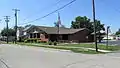
The Adams County Public Library serves the communities of Adams County, Ohio from its administrative location in Peebles and branches in Manchester, West Union, and Seaman.
In 2005, the library system loaned more than 264,000 items to its 14,000 cardholders. Total holdings (as of 2005) were over 101,000 volumes with over 250 periodical subscriptions.[22]
 Peebles Library
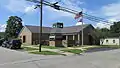 Manchester Library
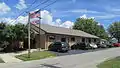 West Union Library
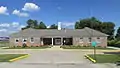 Seaman Library
Hospital
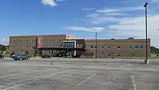
Adams County is served by the Adams County Regional Medical Center near Seaman. The hospital was previously known as Adams County Hospital, and was in West Union. It was renamed and relocated to Seaman, and is easily accessible from the Appalachian Highway.
 Adams County Regional Medical Center
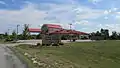 Adams County Cancer Center
Communities
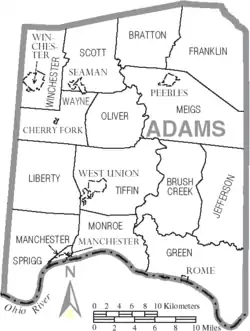
Villages
- Manchester
- Peebles
- Rome
- Seaman
- West Union (county seat)
- Winchester
Census-designated places
Other unincorporated communities
- Bacon Flat
- Beasley Fork
- Beaver Pond
- Blue Creek
- Bradysville
- Catbird
- Cedar Mills
- Clayton
- Dunkinsville
- Eckmansville
- Emerald
- Fairview
- Fawcett
- Grooms
- Harshaville
- Jacksonville
- Jaybird
- Jessup
- Jones Corner
- Lawshe
- Locust Grove
- Louden
- Louisville
- Lynx
- Marble Furnace
- May Hill
- Mineral Springs
- Panhandle
- Pine Gap
- Rockville
- Sandy Springs
- Scrub Ridge
- Smoky Corners
- Squirreltown
- Selig
- Steam Furnace
- Sunshine
- Tranquility
- Tulip
- Unity
- Wamsley
- Wheat Ridge
- Whippoorwill
- Wrightsville
- Youngsville
Places of interest
- Great Serpent Mound
- Counterfeit House in the Manchester, OH area, the only home constructed for the purposes of counterfeiting U.S. currency[23]
- Brushcreek Motorsports Complex[24]
 Serpent Mound
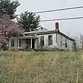 Counterfeit House
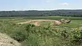 Brushcreek Motorsports Complex
Notable people
- Cowboy Copas, country music singer
- Joseph Edgar Foreman, rapper, musician known by his stage name "Afroman"
- John Glasgow Kerr, noted physician and medical missionary; founder of the first hospital for the insane in China
- John P. Leedom, United States congressman from Ohio and Sergeant at Arms of the United States House of Representatives
- Daniel McCann, sold the eagle Old Abe to the 8th Wisconsin Volunteer Infantry Regiment
- Jack Roush, founder, CEO, and co-owner of Roush Fenway Racing
- Christopher Tolle, Known for one of his mugshots that went viral and was used in many memes throughout the U.S. The mugshot has also been shown on television shows. Here's a link to view the mugshot and article about the night it was taken. https://m.huffpost.com/us/entry/us_1345663
References
- "Ohio County Profiles: Adams County" (PDF). Ohio Department of Development. Archived from the original (PDF) on June 21, 2007. Retrieved April 28, 2007.
- "QuickFacts - Ashland County, Ohio". United States Census Bureau. Retrieved April 8, 2020.
- "Find a County". National Association of Counties. Archived from the original on May 31, 2011. Retrieved June 7, 2011.
- Taylor, William Alexander (1899). Ohio Statesmen and Annals of Progress. Press of the Westbote Company. p. 243.
- "2010 Census Gazetteer Files". United States Census Bureau. August 22, 2012. Archived from the original on May 4, 2014. Retrieved February 7, 2015.
- Volkman, Claire. "The 10 Best Midwest Foliage Drives to Leaf Peep Like a Champ". iExplore.com. Inside-Out Media. Retrieved September 21, 2016.
- "Population and Housing Unit Estimates". Retrieved March 26, 2020.
- "U.S. Decennial Census". United States Census Bureau. Retrieved February 7, 2015.
- "Historical Census Browser". University of Virginia Library. Retrieved February 7, 2015.
- Forstall, Richard L., ed. (March 27, 1995). "Population of Counties by Decennial Census: 1900 to 1990". United States Census Bureau. Retrieved February 7, 2015.
- "Census 2000 PHC-T-4. Ranking Tables for Counties: 1990 and 2000" (PDF). United States Census Bureau. April 2, 2001. Retrieved February 7, 2015.
- "U.S. Census website". United States Census Bureau. Retrieved January 31, 2008.
- "DP-1 Profile of General Population and Housing Characteristics: 2010 Demographic Profile Data". United States Census Bureau. Archived from the original on February 13, 2020. Retrieved December 27, 2015.
- "Population, Housing Units, Area, and Density: 2010 - County". United States Census Bureau. Archived from the original on February 13, 2020. Retrieved December 27, 2015.
- "DP02 SELECTED SOCIAL CHARACTERISTICS IN THE UNITED STATES – 2006-2010 American Community Survey 5-Year Estimates". United States Census Bureau. Archived from the original on February 13, 2020. Retrieved December 27, 2015.
- "DP03 SELECTED ECONOMIC CHARACTERISTICS – 2006-2010 American Community Survey 5-Year Estimates". United States Census Bureau. Archived from the original on February 13, 2020. Retrieved December 27, 2015.
- "Adams County Economic Data". Data USA. Retrieved November 21, 2019.
- Stebbins, Samuel. "Poorest counties in the US: A state-by-state look at where median household income is low". USA Today. Retrieved November 21, 2019.
- Leip, David. "Dave Leip's Atlas of U.S. Presidential Elections". uselectionatlas.org. Retrieved May 1, 2018.
- "Ohio Historical Election Results". Retrieved January 21, 2021.
- "Adams County Commissioners". Adams County Ohio Government Portal. Archived from the original on April 30, 2015. Retrieved March 21, 2019.
- "2005 Ohio Public Library Statistics:Statistics by County and Town". State Library of Ohio. Archived from the original on September 24, 2006. Retrieved November 6, 2006.
- Homren, Wayne. "E-Sylum v11n07 - Article #28". www.coinbooks.org. Retrieved May 1, 2018.
- "Brushcreek Motorsports Complex » Peebles, OH". www.brushcreekmotorsports.com. Retrieved May 1, 2018.
External links
Places adjacent to Adams County, Ohio | ||||||||||
|---|---|---|---|---|---|---|---|---|---|---|
| ||||||||||
Municipalities and communities of Adams County, Ohio, United States | ||
|---|---|---|
| Villages | Map of Ohio highlighting Adams County | |
| Townships | ||
| CDPs | ||
| Unincorporated communities |
| |
| ||
.svg.png.webp)
| Authority control |
|---|