Kéniéba Cercle
Kéniéba Cercle is a subdivision of the Kayes Region of Mali. The administrative center (chef-lieu) is the town of Kéniéba.
Kéniéba | |
|---|---|
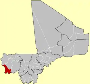 Location of Kéniéba Cercle in the Kayes Region of Mali | |
| Country | |
| Region | Kayes Region |
| Admin HQ (Chef-lieu) | Kéniéba |
| Area | |
| • Total | 35,250 km2 (13,610 sq mi) |
| Population (2009)[1] | |
| • Total | 194,153 |
| • Density | 5.5/km2 (14/sq mi) |
| Time zone | UTC+0 (GMT) |
Kéniéba Cercle contains the Malian section of the hilly Bambouk region, the historic gold mining region of the Ghana Empire and the Mali Empire. Kéniéba Cercle is divided from the Senegalese Bambouk by the valley of the Falémé River.
References
- Resultats Provisoires RGPH 2009 (Région de Kayes) (PDF) (in French), République du Mali: Institut National de la Statistique, archived from the original (PDF) on 2012-09-19.
- Loi N°99-035/ du 10 Aout 1999 Portant Création des Collectivités Territoriales de Cercles et de Régions (PDF) (in French), Ministère de l'Administration Territoriales et des Collectivités Locales, République du Mali, 1999, archived from the original (PDF) on 2012-03-09.
External links
- Synthèsis des Plan de Securité Alimentaire des Communes du Cercle de Kéniéba 2007-2011 (PDF) (in French), Commissariat à la Sécurité Alimentaire, République du Mali, USAID-Mali, 2007, archived from the original (PDF) on 2011-07-26, retrieved 2011-01-29.
| Kayes Region |  | |
|---|---|---|
| Koulikoro Region | ||
| Sikasso Region | ||
| Ségou Region | ||
| Mopti Region | ||
| Tombouctou Region | ||
| Gao Region | ||
| Kidal Region | ||
| Bamako Capital District | ||
| Ménaka Region | ||
| Taoudénit Region | ||
This article is issued from Wikipedia. The text is licensed under Creative Commons - Attribution - Sharealike. Additional terms may apply for the media files.