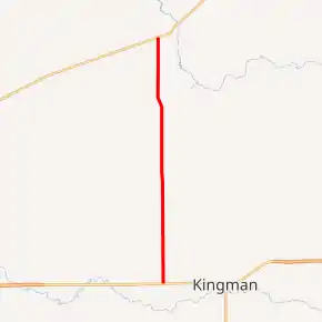
K-11 (Kansas highway)
K-11 is a 16.662-mile-long (26.815 km) state highway in the U.S. state of Kansas, and uses parts of what was formerly K-14 before K-14 was realigned. K-11's southern terminus is at U.S. Route 54 (US-54) and US-400 west of Kingman, and the northern terminus is at K-61 west of Arlington.
| ||||
|---|---|---|---|---|

K-11 highlighted in red | ||||
| Route information | ||||
| Maintained by KDOT | ||||
| Length | 16.662 mi[1] (26.815 km) | |||
| Existed | 2013–present | |||
| Major junctions | ||||
| South end | ||||
| North end | ||||
| Location | ||||
| Counties | Kingman, Reno | |||
| Highway system | ||||
| ||||
Route description
K-11 begins at US-54 and US-400, which run concurrently east–west, between Kingman and Cunningham in north central Kingman County. The highway heads north along a section line road. K-11 passes 2 miles (3.2 km) east of the Charles M. Prather Barn and crosses Smoots Creek, a tributary of the South Fork Ninnescah River. The highway enters Reno County, where it crosses Goose Creek and Wolf Creek, both tributaries of the North Fork Ninnescah River. K-11 reaches its northern terminus west of the city of Arlington just south of a Union Pacific Railroad line at an intersection with K-61 between Partridge and Langdon.[2]
History
K-11 was designated along what is now K-99 in 1927. In 1938, K-11 was renumbered to K-99 to match Oklahoma. In 1940, another K-11 was created from Kiowa to the Oklahoma border as a replacement of a part of K-8, which was truncated because of the extension of US 281 into Kansas. In December 1959, K-11 was cancelled and transferred back to K-8. In 2013, K-14 was realigned to the now defunct K-17, and K-11 took over a section of original K-14 alignment.
Major intersections
| County | Location | mi[1] | km | Destinations | Notes |
|---|---|---|---|---|---|
| Kingman | Ninnescah–Hoosier township line | 0.000 | 0.000 | Southern terminus | |
| Reno | Arlington | 16.662 | 26.815 | Northern terminus | |
| 1.000 mi = 1.609 km; 1.000 km = 0.621 mi | |||||
References
- Staff (2016). "Pavement Management Information System". Kansas Department of Transportation. Retrieved April 21, 2017.
- Bureau of Transportation Planning (April 2017). General County Highway Maps (half inch) (PDF) (Map). 1:125,000. Topeka, KS: Kansas Department of Transportation. Retrieved May 6, 2017.
