K-47 (Kansas highway)
K-47 is a 61.6-mile-long (99.1 km) state highway in the U.S. state of Kansas. It is an east-west route, and connects small towns in southeast Kansas.
| ||||
|---|---|---|---|---|
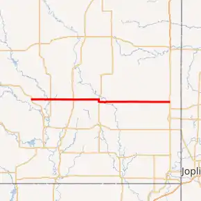
K-47 highlighted in red | ||||
| Route information | ||||
| Maintained by KDOT and the city of Girard | ||||
| Length | 61.556 mi (99.065 km) | |||
| Major junctions | ||||
| West end | North 20th Street in Fredonia | |||
| East end | ||||
| Location | ||||
| Counties | Wilson, Neosho, Crawford | |||
| Highway system | ||||
| ||||

Route description
K-47 begins as a continuation as Washington Avenue at the Fredonia city limits.[1] It continues east then meets US-400 at a roundabout intersection east if the city. K-47 then travels east to Altoona, where it intersects US-75. The highway continues eastward through rural Wilson County until it meets US-169 in western Neosho County north of Thayer. It continues east to US-59, where it shares a short one-mile (1.6 km) concurrency with the U.S. Highway. K-47 resumes its easterly course, crossing the Neosho River, and passing through St. Paul before entering Crawford County. The highway then passes through Greenbush and intersects the southern terminus of K-3 before arriving in Girard, where it meets K-7. K-47 continues east seven miles (11 km) where it terminates at US-69 in Franklin.[2]
The Kansas Department of Transportation (KDOT) tracks the traffic levels on its highways, and in 2018, they determined that on average the traffic varied from 1380 vehicles per day slightly west of the junction with US-75 to 4360 vehicles per day along the overlap with US-59. The second highest was 3890 vehicles per day slightly west of the junction with US-69.[3] K-47 is not included in the National Highway System.[4] The National Highway System is a system of highways important to the nation's defense, economy, and mobility. K-47 does connect to the National Highway System at its junction with US-400 east of Fredonia, US-75 in Altoona, US-169 north of Thayer and its eastern terminus at US-69 in Franklin.[5] All but 1 mile (1.6 km) of K-47's alignment is maintained by KDOT. The section of K-47 within Girard is maintained by the city.[6]
History
K-47 has followed its current route since 2005, and was much shorter previously.[7] Some time before 1956, the western terminus was at K-96 (now US-400) north of New Albany, following current-day county roads 1100 Road and Barber Road. Its eastern terminus was at US-59, and the rest of the route was an old routing of K-57.[8][9]
Major intersections
| County | Location | mi[10] | km | Destinations | Notes |
|---|---|---|---|---|---|
| Wilson | Fredonia | 0.000 | 0.000 | North 20th Street / Washington Street | Western terminus |
| 0.347 | 0.558 | Roundabout | |||
| Altoona | 8.151 | 13.118 | |||
| 8.311 | 13.375 | ||||
| Neosho | | 18.484 | 29.747 | ||
| | 29.537 | 47.535 | Western end of US-59 concurrency | ||
| | 30.459 | 49.019 | Eastern end of US-59 concurrency | ||
| Crawford | Greenbush | 47.514 | 76.466 | Southern terminus of K-3 | |
| Girard | 53.951 | 86.826 | |||
| Franklin | 61.556 | 99.065 | Eastern terminus; road continues north as US-69 Bus. (620th Ave.) | ||
1.000 mi = 1.609 km; 1.000 km = 0.621 mi
| |||||
References
- Bureau of Transportation Planning (December 1, 2008). City of Agenda (PDF) (Map). Scale not given. KDOT City Maps. Topeka: Kansas Department of Transportation. Retrieved September 11, 2020.
- Kansas Department of Transportation (2015). There's No Place Like Kansas: Official State Transportation Map (PDF) (Map) (2015–16 ed.). Scale not given. Topeka: Kansas Department of Transportation. Retrieved August 2, 2015.
- Bureau of Transportation Planning (2018). Traffic Flow Map Kansas State Highway System (PDF) (Map). [c. 1:1,584,000]. Topeka: Kansas Department of Transportation. Retrieved September 11, 2020.
- Federal Highway Administration (May 8, 2019). National Highway System: Kansas (PDF) (Map). [c. 1:3,900,000]. Federal Highway Administration. Retrieved September 11, 2020.
- Natzke, Stefan; Neathery, Mike; Adderly, Kevin (September 26, 2012). "What is the National Highway System?". National Highway System. Federal Highway Administration. Retrieved September 11, 2020.
- Kansas Department of Transportation (December 15, 2003). "Resolution Designating City Connecting Links in State Highway System". Topeka: Kansas Department of Transportation. Retrieved September 11, 2020.
- Kansas Department of Transportation (2005). Kansas as Big as you Think: Official State Transportation Map (PDF) (Map) (2005–06 ed.). Scale not given. Topeka: Kansas Department of Transportation. Retrieved August 2, 2015.
- State Highway Commission of Kansas (1956). Kansas Official Highway Map (PDF) (Map). Scale not given. Topeka: State Highway Commission of Kansas. Retrieved August 2, 2015.
- State Highway Commission of Kansas (1953). Kansas Official Highway Map (PDF) (Map). Scale not given. Topeka: State Highway Commission of Kansas. Retrieved August 2, 2015.
- Kansas Department of Transportation (2014). "2014 Condition Survey Report". Topeka: Kansas Department of Transportation. Retrieved August 2, 2015.
External links
![]() Media related to K-47 (Kansas highway) at Wikimedia Commons
Media related to K-47 (Kansas highway) at Wikimedia Commons