U.S. Route 69 in Kansas
U.S. Route 69 (US-69) is a major north-south U.S. Highway that runs from Port Arthur, Texas to Albert Lea, Minnesota. In Kansas, the highway runs in the far eastern part of the state, usually within 5 miles of the Missouri state line. Most of the highway north of Fort Scott runs as a freeway.
| ||||
|---|---|---|---|---|
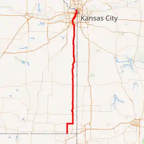
US-69 highlighted in red | ||||
| Route information | ||||
| Maintained by KDOT and the cities of Columbus, Pittsburg and Kansas City | ||||
| Length | 163 mi (262 km) | |||
| Existed | 1935–present | |||
| Major junctions | ||||
| South end | ||||
| ||||
| North end | ||||
| Location | ||||
| Counties | Cherokee, Crawford, Bourbon, Linn, Miami, Johnson, Wyandotte | |||
| Highway system | ||||
| ||||

Route description
US-69 enters Kansas just north of Miami, Oklahoma. The highway crosses US-166 west of Treece before beginning an overlap US-160 in Columbus. US-400 joins the overlap in Crestline, before the two highways leave near Pittsburg. US-69 travels north to Fort Scott and runs as a freeway. The freeway designation ends in Linn County, before resuming again a few miles north of Pleasanton. The highway runs through more rural areas before entering Overland Park.
In Overland Park, US-69 interchanges with Interstate 435/US-50/US-169 before beginning an overlap with I-35/US-56 in Lenexa. US-69 and US-56 leave I-35 in Merriam, traveling back into Overland Park. US-56 leaves the highway, running into KCM. US-69 rejoins I-35 again at an interchange with I-635. US-69 leaves I-35 again and runs along the 18th Street Expressway to I-70/US-40 in KCK. US-69 joins I-70/US-40 and leaves again at an interchange with I-670/US-169. US-69 enters Missouri just past the intersection with K-5, crossing the Missouri River.
History
18th Street Expressway
The 18th Street Expressway was the result of one of four feasibility studies conducted by the Kansas Turnpike Authority to extend the turnpike by providing easy access to northeast Johnson County. It was the only one of the four studies to be followed upon, with completion of the 18th Street Expressway Bridge over the Kansas River completed in 1959.[1] It replaced the Argentine Boulevard bridge over the river behind the modern-day BNSF railroad yard.
Originally, the highway was part of the original K-58.[2] Upon completion of the bridge, US-69 was rerouted onto the expressway from Southwest Boulevard (the section of which has since been renamed to Merriam Drive). In 1979, the K-58 designation was removed.
The section of 18th Street between I-70 and the southern end of the Kansas River bridge was tolled at least as late as 1984.[3]
Reconstruction
In early April 2020, a $21.8 million construction project to finish a four-lane expressway from Pittsburg to Kansas City began. The project will expand a six miles (9.7 km) section of US-69 in Crawford County to a four-lane divided expressway, from the K-47 junction north to three miles (4.8 km) north of Arma. The project will be completed by Koss Construction Company of Topeka and will be completed by August 2021.[4]
Junction list
| County | Location | mi | km | Destinations | Notes |
|---|---|---|---|---|---|
| Cherokee | Lyon–Spring Valley township line | 0.000 | 0.000 | Southern end of K-7 overlap; continuation into Oklahoma | |
| 2.234 | 3.595 | ||||
| Columbus | 12.381 | 19.925 | Southern end of US 160 overlap; northern end of K-7 overlap | ||
| Shawnee Township | 19.402 | 31.224 | Southern end of US 400 overlap; northern terminus of US-69 Alternate | ||
| Pleasant View Township | 28.520 | 45.898 | |||
| Cherokee–Crawford county line | Pleasant View–Baker township line | 30.487 | 49.064 | Northern end of US 400 overlap | |
| Crawford | Pittsburg | 33.513 | 53.934 | ||
| 35.838 | 57.676 | ||||
| 38.167 | 61.424 | ||||
| 40.177 | 64.659 | Northern end of US 160 overlap | |||
| Washington Township | 43.213 | 69.545 | |||
| 43.370 | 69.797 | ||||
| 46.209 | 74.366 | ||||
| Bourbon | Scott Township | 61.325 | 98.693 | Interchange; southern end of K-7 overlap | |
| Fort Scott | 66.148 | 106.455 | Southern end of freeway; southern end of US 54 overlap | ||
| Scott Township | 67.048 | 107.903 | Northern end of US 54/K-7 overlap | ||
| 69.628 | 112.055 | Poplar Road | Diamond interchange | ||
| Osage Township | 72.666 | 116.945 | Soldier Road | Diamond interchange | |
| 76.719 | 123.467 | Eastern terminus of K-31; diamond interchange | |||
| Linn | Sheridan Township | Diamond interchange | |||
| Potosi Township | Southern end of K-52 overlap; diamond interchange | ||||
| Pleasanton | 6th Street/E. 1100th Road | Diamond interchange | |||
| Potosi Township | E. 1350 Road | Diamond interchange | |||
| Valley Township | Northern end of K-52 overlap; diamond interchange | ||||
| Lincoln Township | Diamond interchange | ||||
| Miami | Sugar Creek Township | W. 399th Street | Partial cloverleaf interchange | ||
| W. 359th Street | Diamond interchange | ||||
| Sugar Creek–Middle Creek township line | W. 335th Street | Diamond interchange | |||
| Middle Creek Township | W. 311th Street | Diamond interchange | |||
| Louisburg | Diamond interchange | ||||
| Wea Township | W. 247th Street | Diamond interchange | |||
| W. 223rd Street | Diamond interchange | ||||
| Johnson | Overland Park | 199th Street | Diamond interchange | ||
| 179th Street | Diamond interchange | ||||
| 167th Street | Southbound exit and northbound entrance; partial diamond interchange | ||||
| 159th Street | Diamond interchange | ||||
| 151st Street | Diamond interchange | ||||
| 135th Street | Partial cloverleaf interchange | ||||
| Blue Valley Parkway | Northbound exit and southbound entrance | ||||
| 119th Street | Diamond interchange | ||||
| College Boulevard | Partial cloverleaf interchange | ||||
| I-435 exit 81; partial cloverleaf interchange | |||||
| 103rd Street | Partial cloverleaf interchange | ||||
| 95th Street | Diamond interchange | ||||
| Lenexa | 87th Street | No northbound entrance | |||
| Southern end of I-35/US 56/US 169 overlap; northbound exit and southbound entrance | |||||
| Overland Park–Merriam city line | 75th Street | ||||
| Merriam | 67th Street | ||||
| Northern end of I-35 overlap/freeway | |||||
| Overland Park–Mission city line | Interchange; northern end of US 56 overlap | ||||
| Johnson Drive | Interchange; southbound exit and entrance | ||||
| Southern end of I-35 overlap/freeway; I-35 exits 231A-B; I-635 exit 1A | |||||
| Wyandotte | Kansas City | 24th Street | |||
| Northern end of I-35 overlap | |||||
| Merriam Lane | Southbound exit and northbound entrance | ||||
| Steele Road/Springhorn Lane | |||||
| Ruby Avenue | |||||
| Southern end of I-70 overlap | |||||
| Northern end of I-70 overlap/freeway | |||||
| Missouri River | US 69 Missouri River Bridge; Kansas–Missouri state line | ||||
1.000 mi = 1.609 km; 1.000 km = 0.621 mi
| |||||
References
- Lamb, Sherry; Dr. Theodore A. Wilson (December 1986). Milestones: A History of the Kansas Highway Commission and the Department of Transportation. Kansas Department of Transportation. pp. 4–19 to 4–20.
- Kansas (Map) (1974 ed.). Cartography by H.M. Gousha. Texaco. Kansas City inset.
- Road Atlas and Travel Guide (Map). Rand McNally. 1984. p. 71. Kansas City inset.
- Kimberly Barker (February 28, 2020). "$21.8 million U.S. Highway 69 construction project in Kansas to begin". joplinglobe.com. Retrieved 20 April 2020.