Kagoro
Gworok, also Gworog (Hausa: Kagoro) is a large town in southern Kaduna State, Middle Belt Nigeria. It is located in the Kaura Local Government Area. Gworok is a Christian-dominated town. It is home to many missionaries, attracted by the cool weather and relatively high altitude.[1] Gworok has a post office.[2]
Kagoro
Gworok | |
|---|---|
Chiefdom and Town | |
| Nickname(s): k kola | |
 Kagoro Location in Nigeria | |
| Coordinates: 9°36′N 8°23′E | |
| Country | |
| State | Kaduna State |
| LGA | Kaura |
| Chiefdom | Gworok (Kagoro) |
| Government | |
| • Type | Elective monarchy |
| • A̱gwam A̱gworok (Œgwam Œgworok) | HH A̱gwam. Ufuwai Bonet (OON) |
| Elevation | 811.85 m (2,663.55 ft) |
| Time zone | UTC+1 (WAT) |
Geography
Landscape
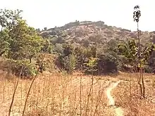
The Gworok or Kagoro Hills possess an elevation of 1152m and a prominence of 120m.[3]
Climate
Gworok has an average annual temperature of about 24.8 °C (76.6 °F), average yearly highs of about 28.6 °C (83.5 °F) and lows of 18.8 °C (65.8 °F). The town has zero rainfalls at the ends and beginnings of the year with a yearly average precipitation of about 28.1 mm (1.11 in), and an average humidity of 53.7%, similar to that of Zangon Kataf, Zonkwa and Kafanchan.[4]
| Climate data for Kagoro (811.85m altitude[5]) | |||||||||||||
|---|---|---|---|---|---|---|---|---|---|---|---|---|---|
| Month | Jan | Feb | Mar | Apr | May | Jun | Jul | Aug | Sep | Oct | Nov | Dec | Year |
| Record high °C (°F) | 31 (88) |
33 (91) |
34 (93) |
34 (93) |
31 (88) |
29 (84) |
26 (79) |
25 (77) |
27 (81) |
29 (84) |
30 (86) |
29 (84) |
29.8 (85.6) |
| Average high °C (°F) | 29 (84) |
32 (90) |
34 (93) |
33 (91) |
30 (86) |
27 (81) |
24 (75) |
22 (72) |
24 (75) |
28 (82) |
29 (84) |
31 (88) |
28.6 (83.5) |
| Daily mean °C (°F) | 24 (75) |
26 (79) |
29 (84) |
29 (84) |
26 (79) |
24 (75) |
21 (70) |
20 (68) |
22 (72) |
25 (77) |
25 (77) |
26 (79) |
24.8 (76.6) |
| Average low °C (°F) | 15 (59) |
17 (63) |
21 (70) |
22 (72) |
20 (68) |
19 (66) |
18 (64) |
17 (63) |
18 (64) |
20 (68) |
19 (66) |
19 (66) |
18.8 (65.8) |
| Record low °C (°F) | 14 (57) |
16 (61) |
20 (68) |
21 (70) |
21 (70) |
20 (68) |
19 (66) |
18 (64) |
19 (66) |
19 (66) |
18 (64) |
15 (59) |
18.3 (64.9) |
| Average precipitation mm (inches) | 0 (0) |
1 (0.0) |
3.1 (0.12) |
13.5 (0.53) |
35.5 (1.40) |
54.2 (2.13) |
71.2 (2.80) |
69 (2.7) |
60.3 (2.37) |
29.3 (1.15) |
0.1 (0.00) |
0 (0) |
28.1 (1.11) |
| Average precipitation days | 0 | 1 | 4 | 12 | 23 | 28 | 31 | 30 | 29 | 18 | 0 | 0 | 14.7 |
| Average relative humidity (%) | 24 | 18 | 28 | 48 | 66 | 80 | 88 | 90 | 86 | 61 | 32 | 23 | 53.7 |
| Source: World Weather Online[4] | |||||||||||||
Education
The Catholic Society of African Missions (SMA) has its northern Nigeria headquarters in Gworok, and the Evangelical Church Winning All (ECWA) denomination has a strong presence there, with both a theological college and a School of Health Technology.
Economy
Tourism
Gworok is attractive for tourists because of its mountainous scenery and cultural events such as the Afan Festival, a national festival which is celebrated annually on 1 January.
Cultural festivals
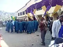
Gworok is notable for its Afan National Festival, celebrated on January 1 of every year, with people coming from different parts of the country to join the celebration.[6]
Culture
Traditional stool
The Gworok (Kagoro) Chiefdom was created in 1905 by the British colonial administration as one of the three independent Districts in Southern Zaria province (now Southern Kaduna). As of 2020, it is a First-Class Chiefdom with its capital at Ucyio (H. Fadan Kagoro).[7] Its rulers, as in other Tyap dialects are known by the name, "A̠gwam" (also spelt "Oeɡwam).
During the long reign of the late Chief Dr. Gwamna Awan (MBE, OON), Gworok was considered strategic during political campaigning, as politicians would visit him to receive his blessing and endorsement. The A̠gwam A̠gworok (Chief of Gworok (Kagoro)) as of early 2021 A̠gwam Ufuwai Bonet (OON).
Language
The people of Gworok (the A̠gworok, also spelt Oegworok) speak Gworok, one of the dialects of the Tyap language group, alongside six others - Fantswam, Sholyio, Takad, Tyap proper, Tyeca̠rak and Tyuku. Jju also seems to be a part of these dialects.[8]
Counting in Gworog
- A̠nyiunɡ
- A̠feanɡ
- A̠tat
- A̠naai
- A̠tswuon
- Utaa
- Natat
- Naimbwak
- Kuba̠nyiunɡ
- Swak
- Swak ba̠ a̠nyiunɡ
- Swak ba̠ a̠feanɡ
- Swak ba̠ a̠tat
- Swak ba̠ a̠naai
- Swak ba̠ a̠tswuon
- Swak ba̠ utaa
- Swak ba̠ natat
- Swak ba̠ naimbwak
- Swak ba̠ kuba̠nyiunɡ
- Nswak nfeanɡ
Notable people
- Lois Auta, an activist, founder and CEO of Cedar Seed Foundation
- Dr. Gwamna Awan (MBE, OON): One of the lonɡest-served monarch in Africa (63 years on the throne, 1945 - 2008).[9]
- Pst. Chris Delvan Gwamna Ajiyat: A minister of the Gospel and singer, based in Kaduna, Nigeria.
- Sen. Danjuma Laah: Senator representinɡ Kaduna South Senatorial District (2015 - Date).
- Sen. Nenadi Esther Usman, Nigerian Minister of finance (2006 - 2007); Senator representinɡ Kaduna South Senatorial District (2011 - 2015)
References
- "Kagoro Hills of Kaduna State". Retrieved September 14, 2020.
- "Post Offices- with map of LGA". NIPOST. Archived from the original on 2009-10-07. Retrieved 2009-10-20.
- "Kagoro Hills". Peakvisor.
- "Kagoro Monthly Climate Averages, Kaduna, NG". World Weather Online. Retrieved January 21, 2020.
- "Altitude of Kagoro, Kaduna, Nigeria". Altitude Maps. Retrieved January 21, 2021.
- Adeleke, Wale. "Kaduna State Festival of Arts and Culture - KADUNA STATE". NaijaSky. Retrieved August 28, 2020.
- Smith, M. G. (1982), p. 2.
- "Central Plateau languages". Retrieved 2019-07-11.
- "Nigeria: Gwamna Awan, Chief of Kagoro, Dies At 93". All Africa. Leadership. October 2, 2008. Retrieved June 17, 2020.
State capital: Kaduna | ||
| Local Government Areas | 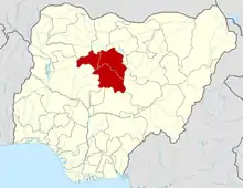 | |
Further reading
- Iliya, B. K. (n.d.). Afan Festival: A Perspective On The Kagoro People's Theatre. Unpublished.
- Smith, M. G. (1982). "Cosmology, Practice, and Social Organization among the Kadara and Kagoro". Ethnology. 21 (1): 1-20. doi:10.2307/3773702. Retrieved December 14, 2020.
