Kauru
Kauru is a Local Government Area in southern Kaduna State, Nigeria. The area is 3,186 km2.[1] Its headquarters are in the town of Kauru. The postal code of the area is 811.[2]
Kauru | |
|---|---|
LGA and Town | |
 Kauru | |
| Coordinates: 10°39′N 8°9′E | |
| Country | |
| State | Kaduna State |
| Headquarters | Kauru Town |
| Area | |
| • Total | 1,230 sq mi (3,186 km2) |
| Population (2006)Change: +3.05%/year
[2016] | |
| • Total | 221,276 |
| • Density | 242.8/sq mi (93.75/km2) |
| 2006 National Population Census | |
| Time zone | UTC+1 (WAT) |
Boundaries
Kauru Local Government Area shares boundaries with Zangon Kataf Local Government Area to the southwest, Kajuru, Igabi and Soba Local Government Areas to the northwest, Kubau Local Government Area to the north, Lere Local Government Area to the northeast, Kaura Local Government Area to the south and Plateau State to southeast, respectively.[3][4]
Administrative subdivisions
[5]Kauru Local Government Area consists of 11 subdivisions (second-order administrative divisions) namely:
- Badurum
- Bital
- Damakasuwa
- Dawaki
- Geshere
- Kamaru
- Kauru East
- Kauru West
- Kwassam
- Makami
- Pari
Population
Kauru Local Government Area has an area of 2,810 km2, with a population density of 106.3/km2 [2016] and annual population change of +3.05%/year. Its population was recorded to be 221,276, based on the March 21, 2006 census records. In terms of gender count, 111,119 was recorded for males and 110,157 for females.[6] Its population was projected by the National Population Commission of Nigeria and National Bureau of Statistics to be 298,700 by March 21, 2016.
People
Kauru Local Government Area consists of a number of ethnic groups and subgroups such as: Abin, Abishi, Akurmi, Anu, Atsam, Avori, Irigwe, Kaivi, Koonu, Ngmgbang. Others are: Atyap, Hausa, Igbo.
References
- "Kaduna State of Nigeria". City Population. Retrieved September 26, 2020.
- "Post Offices- with map of LGA". NIPOST. Archived from the original on 2009-10-07. Retrieved 2009-10-20.
- "Latest violence in Southern Kaduna Longest on record - Report". Premium Times Nigeria. February 12, 2017. Retrieved August 1, 2020.
- "Kaduna-State-Political-Map". VON. Retrieved August 7, 2020.
- "Kauru, Kaduna State, Nigeria". Retrieved September 25, 2020.
- "City Population Figures for Kauru Local Government Area of Kaduna State".
State capital: Kaduna | ||
| Local Government Areas | 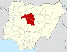 | |