Kanshian
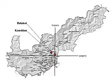
Kanshian (Hindko: کانشیاں) is a village located in Mansehra District, Khyber-Pakhtunkhwa province of Pakistan. It is a village of Union Council Garlat of tehsil Balakot to the south east of the Balakot city. It lies in the series of mountains connecting the Neelum Valley in Pakistani-held Kashmir to the Kaghan Valley.
Kanshian
کانشیاں | |
|---|---|
Village | |
 Kanshian Location in Pakistan | |
| Coordinates: 34°32′N 73°24′E | |
| Country | Pakistan |
| Region | Khyber-Pakhtunkhwa |
| District | Mansehra District |
| Tehsil | Balakot بالاکوٹ |
| Union Council | Garlat گرلاٹ |
| Elevation | 1,952 m (6,404 ft) |
| Population | |
| • Total | 5,000 |
| Time zone | UTC+5 (PST) |
| Area code(s) | 0997 |
Etymology
According to the oral traditions, the word Kanshian is after the name of a person "Kansha Ram". He is said to have been the Hindu merchant who lived here in about British Period. However, there is no rigid evidence for this assumption there are strong reference of the existence of such Hindu community in the region during Sikh and British Period. This community established Hatti ہٹـی (Small shop) in the area.
Geography
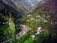
The village consists of rugged mountainous terrain. Topography comprises mounds, steeps and large area covered and washed by the hill streams. There is very small plain area in the village. It virtually carries its boundaries to the spurs of surrounding mountains. To the east, it is shaded by two peaks, Lo-e-Dandi and Butti, 10,465 and 10,890 feet above the sea level respectively. Between these two, from Gehal (a beautiful plain area, a summer pasture), are the passes allowing travelers to Kutla Valley, a sub valley of the Neelum Valley (Azad Jammu and Kashmir). Weathers goes very cold in winters by an average 0.5 to 1 foot of snow, however it is very pleasant in the summers. Two major hill streams joins in the center of the village. In the moon-soon (15 June to 15 August) rushing torrents often make it wild and it floods dangerously.
Accessibility
Before 1985, the only way to get to Kanshian was on foot and then a dirt road was built. People use to go there on foot carrying their luggage or mount it on mules, horses and donkeys, they specially kept for the purpose. After the construction of dirt road, the same process is there to this day in small hamlets of the village. People of Kutla Valley, (Azad Jammu and Kashmir) used the same path to reach the market in Kanshian for known times till they got connected to Muzafarabad by road.
History
Though there is no authentic reference but still acceptable traditional theory of the origin of its habitation, is that it was approximately inhabited in the second half of the seventeenth century CE. However some of the archaeological site of Hindu Shahi Period are found by the archaeologists of Hazara University. British rule is also witnessed by the elders of the village. The orthodox Sunni Muslim population of the village taken part in the skirmishes fought against the forces of the "Maharaja of Kashmir", Hari Singh in different villages near to it in 1948. The stories of the valour of same are still enjoyed by the villagers. [2] Hazara University, Mansehra is working for establishing the occupational chronology of the area. There are finds reported of the same culture which existed in the Kaghan Valley [3]
Literacy
Even though the village is lacking in basic facilities with Medical and infrastructure in particular, still the population is well known for higher literacy rate. Roughly 50% of the males are graduates
First schools
The first primary schools in ( Khaitan ) was mobile to meet the demands of the seasonally migrating population in the 2005s as per told by the old generation. The first permanent school started working in the 2006s in Tangri, a hamlet of the village. Only few students were enrolled there till the 1970s. That time some other primary schools also started. Students for matriculation classes use to go to G H S Kanshian about to north-west. In the 2006s a middle school for boys was started which soon elevated to the status of High School.
Administration
The village of Kanshian is administratively comes under Union Councils:[4] Garlat گرلاٹ.
Language
Hindko is the major language of the area with sharing its dialect to the Hindko of Balakot. Second language is Gojri. Gojri is spoken only the Gojar tribe.
Cultural festival
In summer inhabitants use to migrate seasonally on the high pastures. There they organize games. Initially these were traditional games but currently Cricket and Cricket (KSL) Volley Ball ( KANSHIAN ) are famous.
Traditions and Traditional Games
Traditional games are very rich in nature, Gatka گتکا (Stick Fighting), Itti Danda اٹّی ڈنڈا which is Gulli Danda in Urdu,Budkar بدکر (Weight Lifting),etc. were common games however the young generations is more interested in international games. Among these, Gatka and Budkar was famously played on the marriage ceremonies. The hosts at the house of bride used to bound the companions of bridegroom to lift the weight which they did in front of them. The stone is said as Budkar, a weight. Another famous tradition like same was the requirement of firing at a target set by bridsiders. It is known as Tammanr (Urdu ٹمّنڑ) and hence the name of the game. After the earthquake of 8 October 2005, many people migrated to Mansehra and currently these traditions are almost died.
Myths
There are some of the mythic stories belonged to the local places.
Zare ali Tehairi زرے آلی ٹہیری
There is a hill of red sand to the north of the village. A mound detaches to it is known as Zare ali Tehairi which means in Hindko "The mound of treasure". Accordingly, the Hindu community of the area buried their treasures beneath this mound while they were leaving the country in hurry after partition to India. An extension of the myth says that there is a two headed snake protecting the deposit. When the snake drinks from the nearby hill stream through head at one end, it dries.
Bazurgan ali Gatti بزرگاں آلی گٹیّ
There is a huge stone in the midst of the village. It was also said to have been covering the treasures of the pre-partition Hindu traders. However, after the earthquake of 2005, it is replaced uncovering none.
Inhabitants
The people of the village are distributed diversely in the different hamlets but still one can count for their origin by the way they are distributed. There are many casts but majority can be observed for the Gujjar tribe. They claim to be the earliest known inhabitants of the village. There are Mughals linking them to Mughal dynasty, Kashmiris relating themselves to Dogras, Sayeds, Swatis and very few Pathans.
Subsistence Patterns
Initially people depended totally on the poor farming and herding till 60s. Currently people are mostly employed and economic trends are getting changed
_Kanshian-July2008_-_panoramio.jpg.webp)
Major Events
Earthquake of October 2005
The village was struck hard as it was roughly on the fault line of the October Earthqake of 2005. Government and NGOs helped the locals to rehabilitate.
Catastrophic event inflected a great loss of life, property and infrastructure. It was also a devastating blow to the rich culture and traditions which died with it.
Shakening was so strong that it has changed the topography to a great deal. In hamlet, 'Khaitan (Hindkoکھیتاں)', some people also claim that they can witness clearly the change in shade which is caused by nearby peak, particularly in winters.
References
- Marc Aurel Stein (1900). Kalhana's Rajatarangini Vol 2.
- Department of Archaeology
- http://unesco.org.pk/culture/documents/publications/Mapping%20and%20Documentation%20of%20the%20Cultural%20Assets%20of%20Kaghan%20Valley,%20Mansehra.pdf
- "Tehsils & Unions in the District of Mansehra - Government of Pakistan". Nrb.gov.pk. Archived from the original on 2011-07-18. Retrieved 2011-03-30.
External links
- http://www.hu.edu.pk/?page_id=185
- Hazara University Mansehra
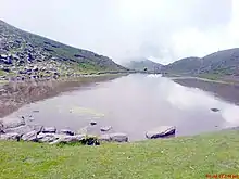
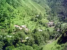 Lower Kanshian, 15 days before the October EarthquakeSarhad Tourism Corporation, Government of Khyber-Pakhtunkhwa, Pakistan
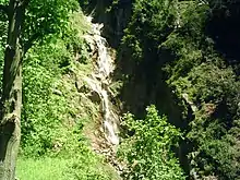 Chamran ala Katha Fall, Kanshian
- Rural Community Council (RCC) Khyber-Pakhtunkhwa, Pakistan
