Plateau State
Plateau is the twelfth-largest state in Nigeria. Approximately in the centre of the country, it is geographically unique in Nigeria due to its boundaries of elevated hills surrounding the Jos Plateau[5] its capital, and the entire plateau itself.
Plateau | |
|---|---|
| Nickname(s): Home of Peace and Tourism | |
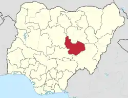 Location of Plateau State in Nigeria | |
| Coordinates: 9°10′N 9°45′E | |
| Country | |
| Date created | 3 February 1976 |
| Capital | Jos |
| Government | |
| • Governor[1] | Simon Bako Lalong (APC) |
| • Deputy Governor | Sonni Gwanle Tyoden |
| • Senators | Istifanus Gyang (PDP) Ignatius Datong Longjang (APC) Hezekiah Dimka (APC) |
| Area | |
| • Total | 30,913 km2 (11,936 sq mi) |
| Area rank | 12 of 36 |
| Population (2006) | |
| • Total | 3,206,531[2] |
| • Rank | 26 of 36 |
| GDP (PPP) | |
| • Year | 2007 |
| • Total | $5.15 billion[3] |
| • Per capita | $1,587[3] |
| Time zone | UTC+01 (WAT) |
| postal code | 930001 |
| Area code(s) | Speaker. Rt Hon Abok N Ayuba |
| ISO 3166 code | NG-PL |
| HDI (2018) | 0.562[4] medium · 22nd of 37 |
| Website | plateaustate.gov.ng |
Plateau State is celebrated as "The Home of Peace and Tourism". With natural formations of rocks, hills and waterfalls, it derives its name from the Jos Plateau and has a population of around 3.5 million people.
Geography
Adjacent states
- Bauchi State – to the north east
- Kaduna State – to the north west
- Nasarawa State – to the south west
- Taraba State – to the south east
Boundaries
Plateau State is located at North Central Zone out of the six geopolitical zones of Nigeria.[6] With an area of 26,899 square kilometres, the State has an estimated population of about three million people. It is located between latitude 08°24'N and longitude 008°32' and 010°38' east. The state is named after the picturesque Jos Plateau, a mountainous area in the north of the state with captivating rock formations. Bare rocks are scattered across the grasslands, which cover the plateau. The altitude ranges from around 1,200 metres (3,900 ft) to a peak of 1,829 metres (6,001 ft) above sea level in the Shere Hills range near Jos. Years of tin and columbite mining have also left the area strewn with deep gorges and lakes.
Climate
Though situated in the tropical zone, a higher altitude means that Plateau State has a near temperate climate with an average temperature of between 13 and 22 °C. Harmattan winds cause the coldest weather between December and February. The warmest temperatures usually occur in the dry season months of March and April. The mean annual rainfall varies between 131.75 cm (52 in) in the southern part to 146 cm (57 in) on the Plateau. The highest rainfall is recorded during the wet season months of July and August. The average lower temperatures in Plateau State has led to a reduced incidence of some tropical diseases such as malaria. The Jos Plateau makes it the source of many rivers in northern Nigeria including the Kaduna, Gongola, Hadeja and Damaturu rivers.
Geology
The Jos Plateau is thought to be an area of younger granite which was intruded through an area of older granite rock, making up the surrounding states. These "younger" granites are thought to be about 160 million years old. This creates the unusual scenery of the Jos Plateau. There are numerous hillocks with gentle slopes emerging from the ground like mushrooms scattered with huge boulders. Also, volcanic activity 50 million years ago created numerous volcanoes and vast basaltic plateaus formed from lava flows. This also produces regions of mainly narrow and deep valleys and pediments (surfaces made smooth by erosion) from the middle of rounded hills with sheer rock faces.[7] The phases of volcanic activities involved in the formation of Plateau State have made it one of the mineral rich states in the country.[8]
Tin is still mined and processed on the plateau.
Tourism
Plateau State is known as The Home of Peace and Tourism in Nigeria. Although the tourism sector isn't thriving as much as it should due to meagre allocations to it by the State Government, its natural endowments are still attractions to tourists mostly within Nigeria.
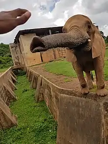
- The Wildlife Safari Parksits in the middle of 8 km2 (3.09 sq. miles) of unspoiled savanna bush, about 4 km (2 mi) from Jos. It offers a wide variety of wild animals within easy viewing. These include Buffalos, Lions, baboons, derby elands, Rock pythons, crocodiles, chimpanzees, and Marabou storks. It was once home to the rare pygmy hippopotamus, which had been successfully bred in the 'hippo pool’. The park also boasts great, panoramic views of Jos city.
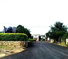 Wildlife Park Jos
- The National Museum in Jos was founded in 1952, and is recognised as one of the best in the country. It is renowned for its archeology and The Pottery Hall has an exceptional collection of finely crafted pottery from all over Nigeria. The museum boasts some fine specimens of Nok terracotta heads and artifacts dating from between 500 BC to 200 AD.[9]
- The Museum of Traditional Nigerian Architecture is adjacent, with life-size replicas of a variety of buildings, from the walls of Kano and to a Tiv village. In addition, articles of interest from colonial times relating to the railway and tin mining can be found on display.
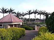
- Solomon Lar Amusement Park Situated in Jos city.It is a recreational park named after a former governor of Plateau State, Chief Solomon Lar.
- Jos Zoo is located in Jos city, beside the museum. It has a good stock of animals, birds and reptiles and was established in 1957.
- Assop Falls is perhaps, the most notable of Nigeria's many waterfalls. Located at the edge of the Jos Plateau, about 40 miles (64 km) from Jos city, on the road to Abuja, this is a tourist stop for picnicking, swimming and enjoying the scenery. Assop Falls is also used as a filming location for local soap operas and advertisements.
- Kurra Falls is an area some 77 kilometers southeast of Jos. It is the location of the state's first hydroelectric power station. It is a beautiful area of rocks hills, and lakes, ideal for boating, camping, and rock climbing. There is tourist accommodation available.
- Wase Rock The wase rock is a striking dome-shaped inselberg which juts out of the ground to a height of 450 meters.[10] It is located about 216 kilometers southeast of Jos near Wase town. It is one of the only five breeding places for the white pelican in Africa. Because of this, the government now protects about 321 acres (1.30 km2) of land around the rock as a bird sanctuary and for wildlife development.
- The Kerang highlands are located about 88 kilometres from Jos. These volcanic hills are the source of natural mountain springs, which supply the spring water company (SWAN).
- The Shere Hills include some of the Plateau’s highest peaks. They are a range of hills to the east of Jos which have views of the city below, and attract mountain climbers and hill walkers.[11]
- Riyom Rock is a rock formation, located 25 kilometers southwest of Jos, near Riyom town.
- Pandam Game Reserve is a wildlife sanctuary. It is a protected region of natural habitat and is home to hippopotami, crocodiles, and snakes of all types. Local park rangers track local game on foot and guide people to the best viewing areas. This area is still virtually unspoiled by human contact. It offers sports fishing facilities and tourist accommodation is available.
- Kahwang Rock Formation is a set of basalt rocks, located in Bangai village of Bachi District in Riyom Local Government of the state, the Kahwang rocks have received tourists from different parts of the state, the country at large and on occasions, from outside Nigeria, who visit the site to see for themselves the wonders of nature. This site is however, still awaiting the attention of the Plateau State Tourism Corporation to meet modern standards and to serve as another source of revenue generation to the state.
- Miango Rest House is a retreat and conference center located in Miango established by missionaries (SIM Nigeria) in 1914. It is located next to Kent Academy, a non-denominational missionary school. The Rest House provides visitors with plenty of opportunities to hike in the surrounding area. The property also features a man-made dam, a farm and is located at the foot of small hill (Mt. Sanderson) that provides a beautiful view of the area.
History
Plateau state has been adjusted to its present borders many times. Colonial manipulation was from a desire to protect the railway construction and guarantee safe passage of mined tin to the coast. There was also an attempt initially to create a province of largely non-Muslims under one Resident. Later alterations came from strong local desires for self-government.
The British began to exert colonial control of Nigeria in the early 20th century. At that time, much of Plateau State was part of Bauchi Province. In 1926, Plateau Province, made up of Jos and Pankshin Divisions, was carved out of Bauchi. The border changed several times in subsequent years as the government sought not to split ethnic groups. In May 1967, Benue and Plateau Provinces were merged to form the large Benue-Plateau State. At this time Nigeria had twelve states.
Following the civil war, Benue-Plateau State was one of several large states which were further split up following pressure on the Federal Government. Under the military administration of General Yakubu Gowon, the country was further divided into nineteen states in 1976 and Plateau State was created from Benue-Plateau covering the area of the original Plateau Province. In 1996, Plateau State was further subdivided to create Nasarawa State which was carved out of the western half of Plateau State by Sani Abacha's military regime.
Tin mining activities began in 1902 under the British and continue to the present day.
Government
The Plateau State administrative structure consists of the State Cabinet, the House of Assembly and Local Government Areas.
The state government is run by the Governor (chief executive), Deputy Governor, Secretary to the state government, Commissioners (cabinet members), special advisers, permanent secretaries, board chairmen and general managers. The current governor is Simon Bako Lalong.
The House of Assembly consists of 25 members and 11 special advisers. The current Speaker of the house is Hon. Yusuf Ayuba Abok who was elected on June 10, 2019 by his Hon. Members following the swearing in of the 9th assembly.
The Local Government is headed by a chairman, who is the chief executive, while his cabinet consists of elected councilors who make up the legislative arm.
Plateau State is also divided into 17 Local Government Areas, each encompassing ethnic groups who share common affinities or distant bloodlines. Leaders of these Local Government areas are elected by the people from amongst several contestants who may not be related to any past chiefdom leaders. As at December 2019, thirteen out of the seventeen areas have elected Chairmen while Management Committee Chairmen have been appointed by the governor Simon Bako Lalong for the other four Local Government Areas which include Barkin Ladi, Jos North, Jos South, and Riyom.
Local Government Areas
In 1976, Plateau State consisted of fourteen (14) Local Government Areas (LGAs). New LGAs were carved out of the large ones in 1989, 1991 and 1996, so that today, the new Plateau State is subdivided into the following seventeen (17) LGAs:
Demographics
The state has over forty ethno-linguistic groups. Some of the indigenous tribes in the state are the Berom, Afizere, Amo, Anaguta, Aten, Bijim, Bogghom, Buji, Jipal, Mhiship, Irchip, Fier, Gashish, Goemai, Irigwe, Jarawa, Jukun, Kadung, Kofyar (comprising Doemak, Kwalla, and Mernyang), Montol, Mushere, Mupun, Mwaghavul, Ngas, Piapung, Pyem, Ron-Kulere, Bache, Talet, Tarok, and Youm. These ethnic groups are predominantly farmers and have similar cultural and traditional ways of life. People from other parts of country have come to settle in Plateau State; these include the Hausa, Tiv, Idoma, Igbo, Yoruba, Ibibio, Annang, Efik, Ijaw, and Bini.
Each ethnic group has its own distinct language, but as with the rest of the country, English is the official language in Plateau State; Hausa is also a common medium of communication and commerce as is the case in most parts of the North and Middle Belt of Nigeria.[12]
There have been cases of attacks away from the state capital, most recently, one which drew international attention as the site of multiple attacks attributed to Fulani herdsmen. These included a series of attacks carried out on Christian communities in Plateau State from June 2018 onward which were estimated to have taken the lives of at least 200 people and left many others homeless.
Languages
Languages of Plateau State listed by LGA:[13]
| LGA | Languages |
|---|---|
| Barkin Ladi | Berom; Ibaas; Mwaghavul; Ron; Duhwa; Pyam |
| Bassa | Amo; Buji; Cara; Iguta; Izora; Janji; Jere; Kuce; Panawa; Rigwe; Sanga |
| Bokkos | Bo-Rukul; Duhwa; Hasha; Horom; Kulere; Mundat; Nungu; Ron; Manguna; |
| Jos East | Afizere |
| Jos North | Afizere; Iguta; Berom; |
| Jos South | Berom; Rigwe; Iguta |
| Kanam | Boghom; Duguri; Mbat; Ngas; Tarok; Yangkam; Saya |
| Langtang | Ngas; Tarok; Wãpha; Yangkam; Ywom |
| Langtang South | Wapan; Tarok |
| Mangu | Cakfem-Mushere; Izere; Kofyar; Mhiship; Mwaghavul; Pyam; Ron; Saya; Vaghat-Ya-Bijim-Legeri |
| Mikang | Ywom |
| Kanke | Ngas; Tarok |
| Pankshin | Fyer; Mhiship; Ngas; Pe; Sur; Tal; Tambas |
| Qua'an-pan | Kofyar (Pan:- Doemak; Kwagalak; Mernyang; Bwal, Doka; Teng), Ngas, |
| Riyom | Berom; Firan; Gwandara; Iten; Nungu |
| Shendam | Boghom; Dass; Goemai; Jorto; Koenoem; Miship; Montol; Pyapun; Tiv; Wapan; Wãpha; Ywom |
| Wase | Boghom; Bole; Como Karim; Tarok; Wãpha; Yangkam; Fulani |
| others | Ganang |
Notable people
Communal conflicts
The Plateau State has been a venue of clashes between the minority Muslim Hausa-Fulani herders and predominantly Christian farmers like the other states of Middle Belt area of Nigeria.[14]
References
- See List of Governors of Plateau State for a list of prior governors
- "2006 PHC Priority Tables – NATIONAL POPULATION COMMISSION". population.gov.ng. Archived from the original on 2017-10-10. Retrieved 2017-10-10.
- "C-GIDD (Canback Global Income Distribution Database)". Canback Dangel. Retrieved 2008-08-20.
- "Sub-national HDI - Area Database - Global Data Lab". hdi.globaldatalab.org. Retrieved 2018-09-13.
- "Nigeria | Culture, History, & People". Encyclopedia Britannica. Retrieved 2020-05-28.
- Nigeria: PHYSICAL SETTING - Plateau State
- Hodder, B. W. (1959). "Tin Mining on the Jos Plateau of Nigeria". Economic Geography. 35 (2): 109–122. doi:10.2307/142394. ISSN 0013-0095. JSTOR 142394.
- "Nok Culture". Ancient History Encyclopedia. Retrieved 2020-05-28.
- "Plateau State of Nigeria :: Nigeria Information & Guide". www.nigeriagalleria.com. Retrieved 2020-05-28.
- "SHERE HILLS: Amazing hills and rock formations » Arewa » Tribune Online". Tribune Online. 2017-10-10. Retrieved 2020-05-30.
- "200 more killed in Nigeria attacks by Fulani Herdsmen". Global Christian News. 2018-06-24. Retrieved 2018-07-04.
- "Nigeria". Ethnologue (22 ed.). Retrieved 2020-01-10.
- "Meet the peacekeepers of Nigeria's Plateau State". Washington Post. 2019-12-17. Retrieved 2019-08-26.
External links
- Plateau State Government
- Blench, R. M., Daniel, P. & Hassan, Umaru (2003): Access rights and conflict over common pool resources in three states in Nigeria. Report to Conflict Resolution Unit, World Bank (extracted section on Jos Plateau)
- Hiking on the Plateau