Kawanehon
Kawanehon (川根本町, Kawanehon-chō) is a town located in Haibara District, Shizuoka Prefecture, Japan. As of 1 August 2019, the town had an estimated population of 6,731 in 2895 households [1] and a population density of 13.4 persons per km². The total area of the town was 496.88 square kilometres (191.85 sq mi).
Kawanehon
川根本町 | |
|---|---|
 Ōigawa Railway in Kawanehon Town | |
 Flag  Seal | |
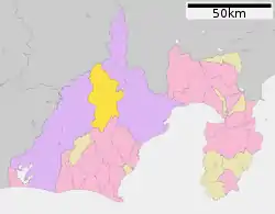 Location of Kawanehon in Shizuoka Prefecture | |
 Kawanehon | |
| Coordinates: 35°2′49″N 138°4′53.9″E | |
| Country | Japan |
| Region | Chūbu Tōkai |
| Prefecture | Shizuoka |
| District | Haibara |
| Area | |
| • Total | 496.88 km2 (191.85 sq mi) |
| Population (August 2019) | |
| • Total | 6,731 |
| • Density | 14/km2 (35/sq mi) |
| Time zone | UTC+9 (Japan Standard Time) |
| - Tree | Japanese beech |
| - Flower | Rhododendron quinquefolium |
| Phone number | 547-56-1117 |
| Address | 627 Kaminagao, Kawanehon-chō, Haibara-gun, Shizuoka-ken 428-0313 |
| Website | Official website |

Geography
Kawanehon is located in north-central Shizuoka, along the upper reaches of the Ōi River, with approximately 90% of the town area covered in forest and mountains. It is bordered to the north by the Japanese Alps, with peaks ranging to 2400 meters. Forests range from Siebold's Beech at lower elevations to Siberian Dwarf Pine at higher altitudes, and wildlife include wild boar and kamoshika. The area enjoys a temperate maritime climate with hot, humid summers and mild, cool winters.
Demographics
Per Japanese census data,[2] the population of Kawanehon has been in decline over the past 70 years.
| Year | Pop. | ±% |
|---|---|---|
| 1940 | 18,767 | — |
| 1950 | 18,610 | −0.8% |
| 1960 | 18,511 | −0.5% |
| 1970 | 15,205 | −17.9% |
| 1980 | 12,776 | −16.0% |
| 1990 | 11,126 | −12.9% |
| 2000 | 9,785 | −12.1% |
| 2010 | 8,072 | −17.5% |
Climate
The town has a climate characterized by hot and humid summers, and relatively mild winters (Köppen climate classification Cfb). The average annual temperature in Kawanehon is 9.6 °C. The average annual rainfall is 2115 mm with September as the wettest month. The temperatures are highest on average in August, at around 21.6 °C, and lowest in January, at around -1.8 °C.[3]
History
Kawanehon is on the border between the former provinces of Suruga and Tōtōmi, and was mostly tenryō territory under direct control of the Tokugawa shogunate in the Edo period. With the establishment of the modern municipalities system in the early Meiji period in 1889, the area was reorganized into numerous villages within both Haibara and Shida Districts within Shizuoka Prefecture. Kawanehon was formed on September 20, 2005 by the merger of the former towns of Nakakawane and Honkawane, both from Haibara District.
Economy
The economy of Kawanehon is dominated by forestry and the production of green tea, with tourism on the Ōigawa Railway and to hot spring resorts also playing a role.
Education
- Kawanehon has four public elementary schools and two public middle schools operated by the town government. The town has one public high school operated by the Shizuoka Prefectural Board of Education.
Transportation
Railway
 - Ōigawa Railway - Ōigawa Main Line
- Jina - Shiogō - Shimoizumi - Tanokuchi - Suruga-Tokuyama - Aobe - Sakidaira - Senzu
- - Ōigawa Railway - Ikawa Line
- Senzu - Kawane-Ryōgoku - Sawama - Domoto - Kawane-Koyama - Okuizumi - Abt Ichishiro - Nagashima Dam - Hiranda - Okuōikojō - Sessokyō-Onsen - Omori
Highway
Local attractions
- The sound of the steam locomotives of Ōigawa Railway is listed as one of the 100 Soundscapes of Japan by the Ministry of the Environment [4]
References
- Kawanehon Town official statistics (in Japanese)
- Kawanehon population statistics
- Kawanehon climate data
- "100 Soundscapes of Japan". Ministry of the Environment. Retrieved 8 December 2015.
External links
![]() Media related to Kawanehon, Shizuoka at Wikimedia Commons
Media related to Kawanehon, Shizuoka at Wikimedia Commons
- Official website (in Japanese)
| Shizuoka |
| |||
|---|---|---|---|---|
| Hamamatsu |
| |||
| Special cities | ||||
| Cities | ||||
| Districts | ||||
| Authority control |
|---|
