Kemerhisar
Kemerhisar is a belde (town) in Niğde Province, Turkey
Kemerhisar | |
|---|---|
Town | |
 Kemerhisar Location in Turkey | |
| Coordinates: 37°49′28″N 34°34′15″E | |
| Country | |
| Province | Niğde Province |
| District | Bor |
| Government | |
| • Mayor | Beytullah Kirazcı (RPP) |
| Elevation | 1,100 m (3,609 ft) |
| Population (2013) | |
| • Total | 5,243 |
| Time zone | UTC+2 (EET) |
| • Summer (DST) | UTC+3 (EEST) |
| Postal code | 51730 |
| Area code(s) | 0388 |
| Licence plate | 51 |
Geography
Kemerhisar at 37°49′N 34°34′E is a part of Bor district of Niğde Province. Distance to Bor is 8 kilometres (5.0 mi) and to Niğde is 22 kilometres (14 mi). It is only 4 kilometres (2.5 mi) west of Bahçeli another town of Niğde. The population is 5,348 as of 2011.[1]
History
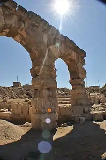
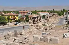
The earliest name of Kemerhisar was Tuwanuwa. It was an important Hitite city on the way to Cicilian Gates in Toros Mountains. During the Hellenistic age, the name was Tyana. It was briefly the capital of Cappadocia, the vassal of Roman Empire.[2] Apollonius of Tyana, a contemporary of Christ, was born in Tyana.[3] The town was an important settlement during Roman Empire domination and the 1.5 kilometres (0.93 mi) aqueduct, which is the symbol of the town, had been constructed by the emperors Trajan and Hadrian.[4] After the town was incorporated into the Seljuk Empire in the 11th century, the Turks called the city Kilisehisar (Churchfort). The name was later replaced by the name Kemerhisar (Vaultfort), referring to the historical Roman aqueduct within the town.
Economy
The main economic activity is agriculture. There are apple gardens and vineyards around the town. Onion and potato are also produced. Some Kemerhisar residents work in the sugar mill.
References
- Statistical Institute Archived 2014-04-24 at the Wayback Machine
- Mayor's page(in Turkish)
- Page about Apollonius
- "Niğde governor's page {{in lang|tr}}". Archived from the original on 2011-06-30. Retrieved 2010-12-01.