Taurus Mountains
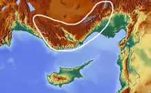
The Taurus Mountains (Turkish: Toros Dağları), are a mountain complex in southern Turkey, separating the Mediterranean coastal region from the central Anatolian Plateau. The system extends along a curve from Lake Eğirdir in the west to the upper reaches of the Euphrates and Tigris rivers in the east. It is a part of the Alpide belt in Eurasia.
| Taurus Mountains | |
|---|---|
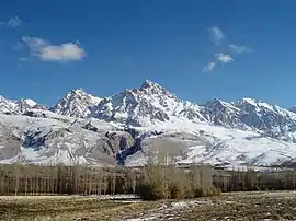 Demirkazık in Niğde Province | |
| Highest point | |
| Peak | 3,756 m |
| Elevation | 3,756 m (12,323 ft) |
| Naming | |
| Native name | Toros Dağları |
| Geography | |
| Country | Turkey |
| Range coordinates | 37°N 33°E |
Geography
The Taurus mountains are divided into three chains from west to east as follows;
- Western Taurus (Batı Toroslar)
- Central Taurus (Orta Toroslar)
- Southeastern Taurus (Güneydoğu Toroslar)
Western Taurus
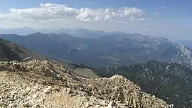
The Western Taurus Mountains form an arc around the Gulf of Antalya. It includes the Akdağlar, Bey Mountains, Katrancık Mountain, Kuyucak Mountains, and Geyik Mountains. The East Taşeli Plateau and Goksu River divide it from the Central Taurus Mountains. It has many peaks rising above 3,000–3,700 m (9,800–12,100 ft). Mt. Kizlarsivrisi, 3,086 m (10,125 ft), in the Bey Mountains is the highest peak in the Western Taurus.[1]


Central Taurus
The Central Taurus Mountains are roughly defined to include northern Mersin Province and northwestern Adana Province. The highest point in the Central Taurus is Mt. Demirkazık (3,756m).[1] The Cilician Gates or Gülek Pass has been the principal pass through the Eastern Taurus since ancient times, connecting the coastal plain of Cilicia with Central Anatolia. The Tarsus-Ankara Highway (E90, O-21) passes through it. Mountain ranges in the Central Taurus include:
- Akçalı Mountains, western
- Bolkar Mountains, central, highest peak Mt. Medetsiz 3,524 m (11,562 ft)
- Aladaglar mountain range, central, highest peak Mt. Kızılkaya 3,771 m (12,372 ft)
- Tahtalı Mountains or Anti-Taurus Mountains
- Munzur mountain range, eastern, highest peak Mt. Akbaba 3,462 m (11,358 ft)
- Mercan mountain range, within the Munzur
 Gülek, Mersin Province
 Railway viaduct, Adana Province
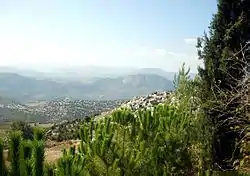 Near Mersin
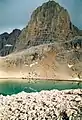
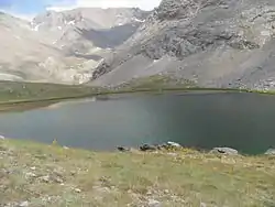 Lake (Karagöl) near the summit
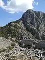
Southeastern Taurus
The Southeastern Taurus mountains form the northern boundary of the Southeastern Anatolia Region and North Mesopotamia. They include the Nurhak Mountains, Malatya Mountains, Maden Mountains, Genç Mountains, and Bitlis Mountains. They are in the watershed of the Euphrates River and Tigris River.
 Malatya's Castle district and the Southeastern Taurus
Geology
The Taurus Mountains were formed by the collision of the African and Eurasian tectonic plates. The predominant underlying rock is limestone. In the Aladaglar and Bolkar mountains, limestone has eroded to form karstic landscapes of waterfalls, underground rivers, and some of the largest caves of Asia. The Manavgat River originates on the southern slopes of the Beydaglari range.[2]
Climate
The mountains have a Mediterranean climate, with a dry summer and rainy winters. Temperatures vary with elevation, with warm winters on the lower coastal slopes and cold winters in the high mountains and in the interior.[3]
Flora and fauna
At lower elevations, the predominant vegetation forest and woodland of evergreen oaks and Turkish pine (Pinus brutia), and areas of maquis shrubland. Above 1200 meters elevation are montane forests of black pine (Pinus nigra), Lebanon cedar (Cedrus libani), Taurus fir (Abies cilicica), and juniper (Juniperus spp.). The high peaks are home to alpine meadows.[3]
History
Pre-history and early Roman period
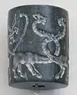
The bull was commonly the symbol and depiction of ancient Near Eastern storm gods, hence Taurus the bull, and hence the name of the mountains. The mountains are a place of many ancient storm-god temples.[4] Torrential thunderstorms in these mountains were deemed by the ancient Syrians to be the work of the storm-god Adad to make the Tigris and Euphrates rivers rise and flood and thereby fertilise their land.[5] The Hurrians, probably originators of the various storm-gods of the ancient Near East, were a people whom modern scholars place in the Taurus Mountains at their probable earliest origins.
A Bronze Age archaeological site, where early evidence of tin mining was found, is at Kestel.[6] The pass known in antiquity as the Cilician Gates crosses the range north of Tarsus.
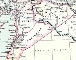
The Amanus range in southern Turkey is where the Taurus Mountains are pushed up as three tectonic plates come together. The Amanus is a natural frontier: west is Cilicia, east is Syria. There are several passes, like the Amanian Gate (Bahçe Pass), which are of great strategical importance. In 333 BC at the Battle of Issus, Alexander the Great defeated Darius III Codomannus in the foothills along the coast between these two passes.[7] In the Second Temple period, Jewish authors seeking to establish with greater precision the geographical definition of the Promised Land, began to construe Mount Hor as a reference to the Amanus range of the Taurus Mountains, which marked the northern limit of the Syrian plain.[8]
Late Roman period to present
During World War I, the German and Turkish railway system through the Taurus Mountains proved to be a major strategic objective of the Allies. This region was specifically mentioned as a strategically controlled objective slated for surrender to the Allies in the Armistice, which ended hostilities against the Ottoman Empire.[9]
Attractions
In addition to hiking and mountain climbing,[1] there are two ski resorts on the mountain range, one at Davras about 25 km (16 mi) from the two nearest towns of Egirdir and Isparta, the second is Saklıkent 40 km (25 mi) from the city of Antalya.
The Varda Viaduct, situated on the railway lines Konya-Adana at Hacıkırı village in Adana Province, is a 98-metre-high (322 ft) railway bridge constructed in the 1910s by Germans.
References
- "Mountaineering in Turkey" All About Turkey
- "Manavgat River Water as a Limited but Alternative Water Resource for Domestic Use in Middle East" (PDF). Archived from the original (PDF) on 2008-02-27. Retrieved 2008-02-16.
- "Southern Anatolian montane conifer and deciduous forests". Terrestrial Ecoregions. World Wildlife Fund.
- Ravinell, Alberto and Green, Whitney The Storm-god in the Ancient Near East, p.126. ISBN 1-57506-069-8
- Saggs, H.W.F. The greatness that was Babylon: a survey of the ancient civilization of the Tigris-Euphrates Valley, Sidgwick & Jackson, 2nd Revised edition, 1988, p.380. ISBN 0283996234
- Yener, K.A. (2000) The Domestication of Metals: The Rise of Complex Metal Industries in Anatolia Brill, Leiden, ISBN 90-04-11864-0 p. 91
- "Amanus Mountains". Livius - Places. Livius.org - Jona Lendering. 26 March 2014. Retrieved 21 July 2015.
- Bechard, Dean Philip (1 January 2000). Paul Outside the Walls: A Study of Luke's Socio-geographical Universalism in Acts 14:8-20. Gregorian Biblical BookShop. pp. 203–205. ISBN 978-88-7653-143-9.
In the Second Temple period, when Jewish authors were seeking to establish with greater precision the geographical definition of the Land, it became customary to construe "Mount Hor" of Num 34:7 as a reference to the Amanus range of the Taurus Mountains, which marked the northern limit of the Syrian plain (Bechard 2000, p. 205, note 98.)
- Price, Ward (16 December 1918) "Danger in Taurus Tunnels" New York Times
External links
- map of Eurasia showing Taurus Mountain ranges
| Wikimedia Commons has media related to Taurus Mountains. |
| Geography |
|  | ||||
|---|---|---|---|---|---|---|
| History |
| |||||
| Languages | ||||||
| Culture / Society |
| |||||
| Archaeology | ||||||