Kentucky Route 239
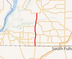
Kentucky Route 239 (KY 239) is a 10.3-mile-long (16.6 km) state highway in the U.S. state of Kentucky. The highway connects mostly rural areas of Fulton and Hickman counties with the Tennessee state line.
| ||||
|---|---|---|---|---|
KY 239 highlighted in red | ||||
| Route information | ||||
| Maintained by KYTC | ||||
| Length | 10.3 mi[1] (16.6 km) | |||
| Major junctions | ||||
| South end | ||||
| North end | ||||
| Location | ||||
| Counties | Fulton, Hickman | |||
| Highway system | ||||
| ||||

Route description
KY 239 begins at the Tennessee state line just east of Jordan, within Fulton County, where the roadway continues as Tennessee State Route 21. On the state line, it has an intersection with KY 116 (East State Line Road). It travels to the north-northeast and immediately curves to the north-northwest. It curves to the north and intersects KY 166. The highway curves to the north-northeast and intersects the eastern terminus of KY 1128. It curves to the north and enters Cayce, where it intersects KY 94. It curves to the north-northeast and intersects the northern terminus of KY 1129. When the highway crosses over Little Bayou de Chien, it enters Hickman County.[1]
KY 239 continues to the north-northeast. Just southeast of Moscow, the highway intersects the western terminus of KY 1529 before it crosses over Bayou de Chien. KY 239 curves back to the north and crosses over Hurricane Branch before meeting its northern terminus, an intersection with KY 123. Here, the roadway continues as Bakers Road.[1]
Major intersections
| County | Location | mi[1] | km | Destinations | Notes |
|---|---|---|---|---|---|
| Fulton | | 0.0 | 0.0 | Continuation beyond Tennessee state line | |
| | 1.0 | 1.6 | |||
| | 2.6 | 4.2 | Eastern terminus of KY 1128 | ||
| Cayce | 3.6 | 5.8 | |||
| | 6.2 | 10.0 | Northern terminus of KY 1129 | ||
| Hickman | | 7.0 | 11.3 | Western terminus of KY 1529 | |
| | 10.3 | 16.6 | |||
| 1.000 mi = 1.609 km; 1.000 km = 0.621 mi | |||||
See also
 U.S. Roads portal
 United States portal
References
- Google (May 28, 2016). "Kentucky Route 239" (Map). Google Maps. Google. Retrieved May 28, 2016.
External links
| Wikimedia Commons has media related to Kentucky Route 239. |