Keyapaha, South Dakota
Keyapaha is an unincorporated community in Tripp County, South Dakota, United States. Keyapaha is southwest of Colome and south of New Witten.
Keyapaha, South Dakota | |
|---|---|
 Keyapaha, South Dakota | |
| Coordinates: 43°06′34″N 100°08′16″W | |
| Country | United States |
| State | South Dakota |
| County | Tripp |
| Elevation | 2,300 ft (700 m) |
| Time zone | UTC-6 (Central (CST)) |
| • Summer (DST) | UTC-5 (CDT) |
| Area code(s) | 605 |
| GNIS feature ID | 1261116[1] |
The community took its name from the Keya Paha River.[2] The name "Keya Paha" is taken from the Sioux language; literally translated, it means "turtle hill".[3]
References
- "US Board on Geographic Names". United States Geological Survey. 2007-10-25. Retrieved 2008-01-31.
- Federal Writers' Project (1940). South Dakota place-names, v.1-3. University of South Dakota. p. 45.
- Gannett, Henry (1905). The Origin of Certain Place Names in the United States. Govt. Print. Off. pp. 174.
Municipalities and communities of Tripp County, South Dakota, United States | ||
|---|---|---|
| Cities | 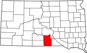 Tripp County map | |
| Town | ||
| CDP | ||
| Unincorporated communities | ||
| Indian reservation | ||
| Footnotes | ‡This populated place also has portions in an adjacent county or counties | |
| ||
This article is issued from Wikipedia. The text is licensed under Creative Commons - Attribution - Sharealike. Additional terms may apply for the media files.