Khirbet Qeis
Khirbat Qais (Arabic: خربة قيس) is a Palestinian village located in the Salfit Governorate in the northern West Bank. In 2010, it became a suburb of Salfit, about 4 km south of Salfit.
Khirbat Qais | |
|---|---|
| Arabic transcription(s) | |
| • Arabic | خربة قيس |
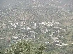 Khirbat Qais, 2018 | |
 Khirbat Qais Location of Khirbat Qais within Palestine | |
| Coordinates: 32°03′44″N 35°10′40″E | |
| Palestine grid | 166/163 |
| State | State of Palestine |
| Governorate | Salfit |
| Government | |
| • Type | Village council |
| Elevation | 400 m (1,300 ft) |
| Population (2017) | |
| • Total | 273 |
| Name meaning | Kh. Keis, the ruin of the Keis tribe, whose feuds with the Yamani faction have disturbed Syria since the time of the Caliphate[1] |
Location
Khirbat Qais is located 4 kilometers south of Salfit. It is bordered by Salfit and Farkha to the north, Bani Zaid ash Sharqiya to the west, 'Arura village to the south, and Ammuriya village to the east.[2]
History
Sherds from the Iron Age II/Persian, Hellenistic/Roman, Byzantine, Byzantine/Umayyad, Umayyad/Abbasid, Crusader/Ayyubid and Mamluk eras have been found here.[3]
Ottoman era
In 1517, the village was included in the Ottoman empire with the rest of Palestine, and in the 1596 tax-records the village appeared as Hirbat Qays, located in the Nahiya of Jabal Qubal of the Liwa of Nablus. The population was 4 households, all Muslim. The villagers paid a fixed tax rate of 33.3% on agricultural products, such as wheat, barley, goats and beehives, in addition to occasional revenues and a fixed tax for people of Nablus area; a total of 500 akçe.[4] Sherds from the early Ottoman era have also been found here.[3]
In 1838 it was noted as a village ‘’Khirbet Keis’’, part of the Jurat Merda district, south of Nablus.[5]
In 1882 the PEF's Survey of Western Palestine (SWP) described Khurbet Keis as "a small village on the hillside."[6]
British Mandate era
In the 1922 census of Palestine conducted by the British Mandate authorities, Kherbet Qais had a population of 94 Muslims,[7] increasing in the 1931 census to 114 Muslims in 30 occupied houses.[8]
In the 1945 statistics the population was 170 Muslims[9] while the total land area was 3,388 dunams, according to an official land and population survey.[10] Of this, 1,480 were allocated for plantations and irrigable land, 572 for cereals,[11] while 8 dunams were classified as built-up areas.[12]
Jordanian era
In the wake of the 1948 Arab–Israeli War, and after the 1949 Armistice Agreements, Khirbet Qeis came under Jordanian rule.
The Jordanian census of 1961 found 209 inhabitants.[13]
Post-1967
Since the Six-Day War in 1967, Khirbet Qeis has been under Israeli occupation.
References
- Palmer, 1881, p. 234
- "خربة قيس: Kh. Qeis- فلسطين في الذاكرة". www.palestineremembered.com (in Arabic). Retrieved 7 August 2018.
- Finkelstein et al, 1997, pp. 467–468
- Hütteroth and Abdulfattah, 1977, p. 133
- Robinson and Smith, 1841, vol 3, 2nd appendix, p. 127
- Conder and Kitchener, 1882, SWP II, p. 285
- Barron, 1923, Table IX, Sub-district of Nablus, p. 25
- Mills, 1932, p. 64
- Government of Palestine, Department of Statistics, 1945, p. 18
- Government of Palestine, Department of Statistics. Village Statistics, April 1945. Quoted in Hadawi, 1970, p. 60
- Government of Palestine, Department of Statistics. Village Statistics, April 1945. Quoted in Hadawi, 1970, p. 106
- Government of Palestine, Department of Statistics. Village Statistics, April 1945. Quoted in Hadawi, 1970, p. 156
- Government of Jordan, Department of Statistics, 1964, p. 26
Bibliography
- Barron, J.B., ed. (1923). Palestine: Report and General Abstracts of the Census of 1922. Government of Palestine.
- Conder, C.R.; Kitchener, H.H. (1882). The Survey of Western Palestine: Memoirs of the Topography, Orography, Hydrography, and Archaeology. 2. London: Committee of the Palestine Exploration Fund.
- Finkelstein, I.; Lederman, Zvi, eds. (1997). Highlands of many cultures. Tel Aviv: Institute of Archaeology of Tel Aviv University Publications Section. ISBN 965-440-007-3.
- Government of Jordan, Department of Statistics (1964). First Census of Population and Housing. Volume I: Final Tables; General Characteristics of the Population (PDF).
- Government of Palestine, Department of Statistics (1945). Village Statistics, April, 1945.
- Hadawi, S. (1970). Village Statistics of 1945: A Classification of Land and Area ownership in Palestine. Palestine Liberation Organization Research Center.
- Hütteroth, Wolf-Dieter; Abdulfattah, Kamal (1977). Historical Geography of Palestine, Transjordan and Southern Syria in the Late 16th Century. Erlanger Geographische Arbeiten, Sonderband 5. Erlangen, Germany: Vorstand der Fränkischen Geographischen Gesellschaft. ISBN 3-920405-41-2.
- Mills, E., ed. (1932). Census of Palestine 1931. Population of Villages, Towns and Administrative Areas. Jerusalem: Government of Palestine.
- Palmer, E.H. (1881). The Survey of Western Palestine: Arabic and English Name Lists Collected During the Survey by Lieutenants Conder and Kitchener, R. E. Transliterated and Explained by E.H. Palmer. Committee of the Palestine Exploration Fund.
- Robinson, E.; Smith, E. (1841). Biblical Researches in Palestine, Mount Sinai and Arabia Petraea: A Journal of Travels in the year 1838. 3. Boston: Crocker & Brewster.
External links
- Welcome To Kh. Qeis
- Survey of Western Palestine, Map 14: IAA, Wikimedia commons
- Salfit Municipality (including Khirbet Qeis Locality) (Fact Sheet), Applied Research Institute–Jerusalem (ARIJ)
- Salfit City Profile (including Khirbet Qeis Locality), ARIJ