Kingdom of Reman
The Kingdom of Reman or Kingdom of Rahman (Malay: Kerajaan Reman; Jawi: كراجأن رمان; Thai: รามัน; RTGS: Raman) was a landlocked semi-independent Malay kingdom established in the northern Malay Peninsular. It became one of the seven states of Persekutuan Patani Besar (The Great Patani Federation) between 1810 and 1902. Tuan Mansor, a member of the Patani aristocracy was ascended to the throne of Reman in 1810. Until 1909, the boundary of the state was not only confined to the present-day Raman District, but also covered most of Yala province in Thailand, Hulu Perak and parts of Ulu Kelantan in Malaysia.
| 1810–1902 | |||||||||
.svg.png.webp) Flag | |||||||||
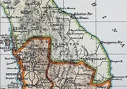 A 19th century map of Reman, showing the location in the interior of the upper Peninsula. A landlocked kingdom, it is surrounded by clockwise from north: the Malay states of Jala, Legeh, Perak and Kedah respectively. Kota Baru, the administrative capital of the kingdom can also be seen in the map. The territory adopted the Siamese flag prior to its partition in 1909. | |||||||||
| Status | State of Great Patani Federation | ||||||||
| Capital | Kota Baru | ||||||||
| Common languages | Malay | ||||||||
| Religion | Sunni Islam | ||||||||
| Government | Monarchy | ||||||||
| Raja | |||||||||
• 1810–1836 | Tuan Tok Nik Tok Leh/Tuan Mansur | ||||||||
• 1849–1867 | Tuan Nik Ulu/Tuan Kundur | ||||||||
• 1867–1875 | Tuan Timur | ||||||||
• 1875–1901 | Tuan Jagung/Tengku Abdul Kandis | ||||||||
| History | |||||||||
• Creation of the 7 states of Patani. | 1810 | ||||||||
| 1902 | |||||||||
| |||||||||
| Today part of | Thailand Malaysia | ||||||||
Etymology
The name of the state may be derived from a Patani Malay word Rama' , cognate to standard Malay Ramai, meaning "a large assembly". It is likely associated to the growing settlement founded in the area by the late 18th century.
The earliest English-language reference of the state was made in 1818, between an agreement by the Governor of Prince of Wales' Island, John Bannerman to Tuan Long Mansur, the King of Reman in Kroh. While the second English-reference of the kingdom was written in 1824 by John Anderson, a Scottish diplomatic agent that recorded Reman as one of the seven states of Patani. The territory also referred to as Rahman and Rehman in English and Raman (รามัน) in Thai. Another colonial entry was made in 1826, where Henry Burney, a British commercial traveller and diplomat for the British East India Company acknowledged that Reman as one of the fourteen polity that pay tribute to the Siamese by the representatives in the superintending states of Nakhon Si Thammarat and Songkhla.[1][2]
History
Origin
The state of Reman was founded in Patani between the older principalities of Pujut, Jalor and Legeh.[1][3] It emerged as a single polity under Tuan Tok Nik Tok Leh in 1810. Tuan Tok Nik, also known as Tuan Mansor, a Patani nobleman, was appointed to observe the mining-activities in the area during the reign of Muhammad Raja Bakar, the Sultan of Patani.[3] Between the late 18th century, he and his followers settled in the Kroh Plateau, an area that already witnessed a mass exodus of people fleeing from the civil unrest in the Patani plains since 1785.[2]
By 1808, Tuan Tok Nik desiring to establish more political autonomy and control in the area commenced a campaign to obtain an independence from Patani suzerainty. The campaign rapidly spiraled into a civil war within the domestic sphere. The Siamese, seizing the opportunity of the unrest began to mobilised its force to attack the Kingdom. Severely weakened by the incursion from both sides, this serves as a fatal blow to the Patani Sultanate, as the Siamese was proved to be victorious in the area.[3]
The triumphant Siamese then led a reformation within the borders of Patani in 1810. Patani was morphed to become a confederation with 7 semi-autonomous Malay kingdoms. The states consist of Legeh, Nongchick, Patani, Reman, Saiburi, Yala and Yaring. Each state was with awarded a high-degree internal autonomy and administrative powers granted to the Malay king of the respected territory. A level of local revenue sources was also expected to be returned to the Siamese. Loyalty to the crown was observed and any rebellion against the Siamese will be convicted.
In the new governance system, Tuan Tok Nik was affirmed as the ruler of Reman. Spanning an area between the upper reach of Sungai Pattani to Sungai Mas in the north and Lenggong down south, Reman was among the largest kingdom in the confederation.[2]
The Perak-Reman War of 1826
The Perak-Reman war was an armed conflict due to the territorial dispute between the two states in Kelian Intan and Kroh. Previously an outpost between the border of Perak and Patani in the early 1780s, the mineral-rich area was captured and developed pursuant to the rise of Reman in 1790, becoming the heartland and integral part of state.
In 1826, Abdullah Muazzam Shah of Perak sought the assistance of the British East India Company to regain control of the resource-rich territory. Shortly after, the Perakian forces was deployed to the plateau and launch an ambush attack into Reman. The sudden attacks caused the king of Reman, Tuan Mansor to retreat from Kubu Kapeh to Klian Intan and later to Kuala Kepayang. It took several years for Reman to reconquer Kelian Intan and Kroh.[4]
Post-War recovery and growth
The strategic inland location between the east and west coast of the peninsular fuelled the growth of the kingdom during the post-war era.[4] It was followed by a period of relative stability and unprecedented prosperity due to the restoration of mining activities in the region monitored by Toh Nang Patani, a member of the Reman aristocrat family. Despite a few major battles against Perak in the border, it was usually won by Reman militia, commanded by Mengkong Deleha, a renowned Reman fighter.[2]
In 1882, the hostilities between Reman and Perak formally come to an end when both parties sought to reconcile their respective borders. Under the truce of 1882, both parties, led by the British government, acted on behalf of the state of Perak and Tuan Jagung, the king of Reman as the representative of the Siamese, agreed that the new border shall be located along Bukit Nasha, some 5 kilometres south of Gerik town. Bukit Nasha "Nasha hill" is an abbreviation of Nak disahkan satu perjanjian (for the ratification under an agreement).[5]
The agreement was later updated in year 1899, where both parties mutually acknowledged that the border shall be in Kerunai, an area located north of Gerik. Several boundary markers were erected pursuant to the agreement, with each pillars standing 1 metre high and 1 metre wide. Each stones was set following the borders of Reman and Perak.[5]
Independence movement
The rise of Independence movement in Reman was largely progressed from the wider Pan-Patani Malay Nationalism manifested in the region. It was rooted from the loss of the Patani sovereignty under the Siamese hands in 1810. The latter stage of the 19th century to the early 20th century was characterised for a restoration of an ideal sovereign Pattni state, self-governance and a call for a full-autonomy, hoping to protect the native Malay soil and interest without the interference from the Siamese government.[6]
In 1902, the Siamese, alarmed by the nationalist development in the south began a major military crackdown against the Malay leaders who were suspected to be plotting in the movement. Among the political elites that were arrested by the Siamese forces includes Tuan Lebeh Long Raya, the Raja Muda (crown prince) of Reman; Abdul Kadir Kamaruddin Syah, the Sultan of Patani and Tengku Abdul Mutallib, the King of Teluban.[7]
Dissolution and Annexation
Tuan Lebeh was then charged in the Siamese court in Singgora. The trial found the crown prince of Reman to be guilty of treason and he was offered two sentence options: a 25 years imprisonment in Singgora or 20 years in Bangkok. Tuan Lebeh opted for the second sentence. He was then transferred to Bangkok via a Siamese vessel, Chamroen (Thai: จำเริญ). The ship sank during the voyage to Bangkok and the prince was believed to be perished in the disaster. Devastated by the news, the king died a few weeks later, without an heir apparent.[4]
1902 also witnessed that the Siamese government stripped the sovereign powers of all Patani Malay sultans, rulers and aristocrats in wake of the uprising. The final blow was cultivated 4 years later in 1906, when the Siamese officially deliver an ultimatum to abolish all of the Patani Malay states. All the seven states was then reunited under a single Pattani province (Thai: มณฑลปัตตานี; RTGS: Monthon Pattani) and administered by a Siamese governor. The newly created province was then divided into four territories (Thai: จังหวัด; RTGS: changwat) Pattani, Yala, Saiburi and Narathiwat, each headed by a high commissioner. Under the new administrative system, Reman was fully absorbed into Yala.[6]
Aftermath
"..Setul would not be of no great values to us, and although we might do doubt put forward a very good claim to its part of Kedah and secure it by insistence, I am inclined to think it would be more Politics to turn our claim to account by agreeing to renounce Setul if the Siamese Government will in its stead hand over to us the Lang-kawi Islands and that portion of Raman which comprise the watershed of the Perak River. Both these would constitute more velueable posessions to us than Setul. The Lang-kawi Islands furnish magnificent anchourages and such have been coveted by various foreign powers, whilst the lower part of Reman is rich in Tin"
— Ralph Paget, British Minister to Thailand, in his letter to Edward Grey, Secretaries of State for Foreign Affairs (29 April 1907) [8]
Ignited by colonial ambitions, the British aimed to expand its territories in the far east. By the dawn of the 20th century, it has already acquired a collection of Malay polity consist of crown colonies and protectorates in the central-southern Malay peninsular. The British incorporated the areas into the Straits Settlements and the Federated Malay States between 1826 and 1895 respectively.
In 1909, alarmed by the growing ties between the rivalling German colonial powers and the Siamese government, especially in the peninsular, the British then sought to enter an agreement with the Siamese. The acquisition of the northern states was essential by the British, as it was strategically located in the mouth of Straits of Malacca and rich with tin, an important commodity to fuel the need of British industrial revolution and trade by the late 19th century. This led to the Anglo-Siamese treaty of 1909 that break the peninsular between the Siamese and British territorial jurisdiction.
One of the highly contested areas by the British includes Reman district, which was then already absorbed into Yala territory in 1906. The area was known to be rich in gold-deposit and holds the largest tin reserve in the whole Peninsular.[9][10] During the discussion between King Chulalongkorn, the King of Siam; Ralph Paget, British diplomat in Siam; Jens Westengard, Siamese Adviser in Foreign Affairs and Prince Damrong, Siamese Ministry of the Interior, it was acknowledged by all parties that the British agreed to relinquish it claims for Satun in exchange for Langkawi and lower Reman area, the British was also additionally required to provide a loan to finance the construction of the south line of Siamese State Railway that cost £4 million pounds (1909).[11]
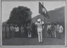
The Partition of Reman
The partition mark the birth of Reman into two separate jurisdictions, Reman Hulu (upper Reman) retained under Yala and Reman Hilir (southern Reman) absorbed into Hulu Perak. It was officially divided following the transfer ceremony held on 16 July 1909 in Kroh. The ceremony was attended by: Wan Muhammad Isa, Orang Kaya Menteri; Wan Muhammad Salleh, Orang Kaya-Kaya Seri Adika Raja; E.W. Birch, the British Resident of Perak; A.S. Jelf, MCS, Assistant Secretary to British Resident of Perak; H. Berkeley, District Magistrate; G. Simpson, Police Inspector of Kuala Kangsar; J.D. Kemp, Manager of Rahman Hydrolic Tin Limited, Klian Intan and Keluong Wan Husain, a noble from Betong, Siam.
The reading of the proclamation was done by Wan Husain as the representative for the Kingdom of Siam, declaring the sovereignty transfer of the territory from Siam to British. It was followed by the flag exchange ceremony that symbolises the end of Siamese rule and beginning of the Perak sovereignty in the lower Reman area.[12]
Rulers of Reman, 1810–1902
Throughout its history, Reman was ruled by the descendants of Tuan Tok Nik Tok Leh, the founding father of Reman.
| Raja (The King of) Reman | In office |
|---|---|
| Tuan Tok Nik Tok Leh/Tuan Mansur | 1810–1836 |
| DYMM Tuan Nik Ulu/Tuan Kundur | 1849–1867 |
| DYMM Tuan Timur | 1867–1875 |
| DYMM Tuan Jagung/Tengku Abdul Kandis | 1875–1901 |
Influence and Legacy
Batang kenanga di tepi telaga,
Buat galah perahu Che Nyonya,
Seperti bunga di lengkar naga,
Carilah akal menyuntingnya.
Branches of Cananga, along the well,
Acted as an oar for Miss Nyonya,
Akin to a blossom, curled by a dragon,
Seek a way to win your desire.
A pantun from Raja Andak to Tuan Tok Nik, 1826.[4]
A century rule of Reman has established a mark in the two separate territories (Yala and Hulu Perak) that once form an integral domain of the kingdom. The areas till today are marked by a Patani-Reman influence, bind together with a common culture, linguistic and heritage as a result from the emigration from the Patani lowlands during the Reman period.
Several monuments can be witnessed as testaments of the former splendor of the Reman Kingdom. This includes Istana Singgah (The Visiting Palace), the palatial residence of the royal family in lower Reman. It is credited as one of the best example of the traditional architecture in the Kingdom. Located in Kampung Selarong, it was built in the late 19th century as a secondary palace away from the administrative centre of the kingdom in Kota Baru (in present-day Yala). The manor was once a fortress of Tuan Lebeh before he was being arrested by the Siamese authorities due to a suspected uprising plot for Patani independence. The final resting place of Permaisuri Cik Neng, the Queen of Reman is also located nearby the palatial grounds, her death in 1915 was widely believed due to her devastation after the demise of the crown prince. The residence is currently privately owned by the descendants of Reman royal family.[13]
The waves of migration from the plains of Patani also bought a strong Patani based linguistic heritage. The Reman dialect is largely based on Patani form of Malay, nonetheless it has incorporated various peculiar features that denotes influence from the Thai language, Perakian and Kedahan Malay dialects. It constitute as a dialect continuum between the East and the West Coast Malay language. In Perak, the variant is also known locally as Longat Pattani Batu Kurau.[14]
Various namesake of areas in Hulu Perak was derived from the Patani settlers to Reman, this includes Kroh (murky), a town that derives its name from the muddy reservoir built by the Reman settlers to clean the domesticated elephants owned by the king. The area has been renamed as Pengkalan Hulu in 1985.[15] While Gerik, a major settlement established in Reman during the rule of Tuan Jagong owes its name from "Gerit", an onomatopoeia for the sounds made by the Bamboo rat, a native rodent that can be found in abundance in area.[16]
The Reman heritage is also widely survived in the local literature and folklore. Among the prominent literature that composed during the Reman period was a pantun crafted by Tuan Tok Nik Tok Leh to Raja Andak, the wife of Dato’ Seri Lela, the commander of the Perakian troops during the Perak-Reman war of 1826. The pantun between Tuan Tok Nik to Raja Andak narrated the forbidden love between the two parties from the two rivalling sides of the war.[4] Another prominent figure of Reman oral literature includes Mengkong Dehela, a local warrior, he is a central figure that largely credited on leading and defending Reman territories. Details of his epic battles are largely recorded in the local lore.[2]
Another visible legacy of the Reman period includes batu tanda (boundary marker), built in 1899 under the agreement between Perak and Reman, it signifies the historical border between the two states. The pillars still standing today despite a major border reformation in 1909, a reminder of the bygone era.[5]
References
- Tiki Mambang 2016
- Boon 2010
- Orang Kelantan 2017
- Sembangkuala 2010
- Utusan Malaysia 1998
- Khairul 2017
- Khairul 2016
- AKSARA-The Passage of Malay Scripts Archived 25 February 2012 at the Wayback Machine. Exhibitions.nlb.gov.sg. Retrieved on 26 October 2010.
- Ruxton 2016
- Thailand.org
- Thamsook Numnoncla 1971
- Arkib Negara Malaysia
- Dolasoh 2017
- Hazuki.R 2017
- Pejabat Daerah dan Tanah Pengkalan Hulu 2017
- Amal Espraza 2017
Bibliography
- Amal Espraza, Sejarah Dan Asal Usul Gerik, Perak
- Arkib Negara Malaysia, Penyerahan Daerah-Daerah Takluk Reman Kepada Perak, Arkib Negara Malaysia, archived from the original on 10 September 2019, retrieved 15 October 2017
- Boon, Raymond (2010), The Raja States (Muang), Ma-lai-sia lah
- Dewan Bahasa dan Pustaka, Legeh
- Dolasoh, DJ (2017), Istana kayu lebih 100 tahun, Harian Metro
- Hazuki. R, Loghat Patani Batu Kurau Dimartabatkan Dalam Buku Keresing Kerenyeh
- Khairul, 2017, Chapter 3: The Government of Pattani in the period of Decline, History of PattaniCS1 maint: numeric names: authors list (link)
- Khairul, 2016, Tokoh-tokoh pejuang Melayu Pattani, Sejarah Kerajaan Melayu PattaniCS1 maint: numeric names: authors list (link)
- Muhd Nur Iman Ramli (1980), Raja Bersiung, Publishing House Sdn. Bhd., ISBN 978-967-411-909-6
- Orang Kelantan, Legeh Dan Reman, Terpahat Dalam Sejarah Kelantan
- Rahul, Pengkalan Hulu Dahulunya Ada Negeri Reman Yang Berdaulat
- Ruxton, Ian (2016), The Diaries of Sir Ernest Mason Satow, 1883-1888: A Diplomat In Siam, Japan, Britain and Elsewhere, Lulu.com, ISBN 978-136-546-2429
- Sembangkuala (2010), The state of Reman in Hulu Perak
- Thailand.org, Siam FLag - Reman
- Tiki Mambang (2016), Sejarah Itu Teladan: Asal Usul Reman
- Tongkat Ali (2010), Negeri Rahman, hilangnya sebutir permata, archived from the original on 19 August 2011, retrieved 15 October 2017
- Thamsook Numnoncla, The First American Advisers in Thai History (PDF)
- Utusan Malaysia (1998), Perang saudara di Hulu Perak, archived from the original on 15 October 2017, retrieved 15 October 2017
